METAR & TAF 6F7
6F7 does not publish a METAR.
Showing the nearest reporting station: KATA (HALL-MILLER MUNI) · 18.4 NM away. Conditions at 6F7 may differ.
METAR · KATA
Observed 12:55Z
KATA 271255Z AUTO RMK AO2 PWINO TSNO $
- Wind
- Calm
- Visibility
- —
- Temp / Dew
- —
- Altimeter
- —
- Clouds
- Clear
- Density alt
- —
- Ceiling
- Unlimited
- Rules
- VFR
Airport info & contacts
Manager on record, flight service, ARTCC, attendance schedule and pattern altitude — published by the FAA and refreshed every 28 days.
Location
- From city
- 4 NM N
- VFR sectional
- MEMPHIS
- ARTCC
- ZFW · FORT WORTH
- NOTAM facility
- FTW (NOTAM-D)
Airport manager
- Name
- CATHY CASON
- Phone
- 903-824-8536
- Address
- 4716 N. US 59, JEFFERSON TX 75657
Flight service · Hours
- FSS FTW
- FORT WORTH1-800-WX-BRIEF
- Attendance
- ALL
Frequencies
Tap any row to copy the frequency to your clipboard.
Runways & pattern
Full pagePattern entry · RWY 07
LEFT TRAFFICRunway end performance
| End | TORA | TODA | ASDA | LDA | VGSI | Approach lights | Obstruction |
|---|---|---|---|---|---|---|---|
| 07 | — | — | — | — | — | — | 10', road, 0' from thr, 0' R of cntrln, slope 0 |
| 25 | — | — | — | — | — | — | 4', fence, 0' from thr, 0' R of cntrln, slope 0 |
Declared distances in feet. TORA = takeoff run available, TODA = takeoff distance, ASDA = accelerate-stop, LDA = landing distance.
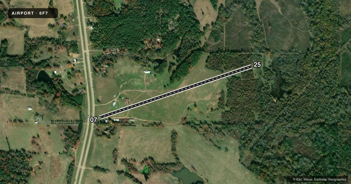
Airport sketch
Runways drawn to scale from FAA survey coordinates, rendered over satellite imagery. Not for navigation.
Approaches & charts
Services on the field
Fuel grades, oxygen, maintenance, ramp storage and lighting — as declared to the FAA by the airport operator.
Fuel & services
- Fuel
- Not available
- Oxygen (bottled)
- Not available
- Oxygen (bulk)
- Not available
Ramp & ground
- Transient storage
- Tie-down
- Hangar
- Landing fee
- No fee published
- Wind indicator
- Yes
- Segmented circle
- No
Fuel & FBOs
Cheapest 100LL and Jet A on the field and nearby. Always confirm with the FBO before taxi.
Airport notes
Surface conditions, obstructions, local procedures, lighting outages and other notes published with each FAA cycle.
General notes
- ULTRALIGHT ACTIVITY ON & INVOF ARPT.
- RWY 07/25 ROLLING TRRN. 84 FT RISE IN RWY ELEV FM RWY 25 TO RWY 07 END.
- NO LINE OF SIGHT BTN RY ENDS.
- RWY 25 10-60 FT TREES ALG EDGE OF RWY, BOTH SIDES.
- FOR CD CTC FORT WORTH ARTCC AT 817-858-7584.
Other notes
- VFR OPNS PRVDD LANDG THRS ARE DSPLCD TO PRVD 20:1 CLNC OVER ANY OBSTNS.
- 07/25RWY MOWED 30 FT WIDE.
VFR map & nearby airports
VFR sectional. Tap any ICAO chip to open that airport.
Key facts · 6F7
Answer card- ICAO
- 6F7
- Name
- MANNING FLD
- Location
- JEFFERSON, TEXAS
- Elevation
- 320 ft MSL
- Traffic pattern altitude
- 1,320 ft MSL (1,000 AGL)
- Control tower
- Non-towered (use CTAF)
- Total runways
- 1
- Longest runway
- 07/25 · 3,600 ft
- Published ILS approaches
- 0
- Published frequencies
- 1
- Magnetic variation
- 5°
- Current flight rules
- VFR
- Current wind
- Calm / unavailable
- Favored runway now
- –
Manning Fld sits near Jefferson, Texas. The field elevation is 320 ft MSL. It has one runway. Runway 07/25 is 3,600 ft of turf, which makes the runway length the main planning number here. There is no control tower. CTAF is 122.9. No ILS approaches are published.
The published pattern altitude is not given. For light piston operations, use the standard 1,000 ft AGL unless the current Chart Supplement says otherwise. The runway is not flat. Published remarks say runway 07/25 has rolling terrain with an 84-foot rise from the 25 end to the 07 end. There is also no line of sight between the runway ends. Runway 25 has trees along both sides near the edge. The runway is mowed 30 feet wide. Visual flight rules operations use displaced landing thresholds to provide 20 to 1 clearance over obstructions.
There are no on-field FBOs listed. Check with the airport operator or the field on CTAF for current services before you go. Ultralight activity also occurs on and near the airport, so keep your scan active in the pattern and on final. For clearance delivery, Fort Worth ARTCC is listed in the remarks. This is a field where a careful preflight and a close look at the runway environment matter more than usual.