METAR & TAF 8F5
8F5 does not publish a METAR.
Showing the nearest reporting station: KOSA (MOUNT PLEASANT RGNL) · 13.5 NM away. Conditions at 8F5 may differ.
METAR · KOSA
Observed 03:35Z
KOSA 260335Z AUTO 19003KT 10SM CLR 29/21 A3001 RMK AO2 T02890214
- Wind
- 190° @ 3 kt
- Visibility
- 10 SM
- Temp / Dew
- 29°C / 21°C
- Altimeter
- 30.01 inHg
- Clouds
- CLR
- Density alt
- 2,067 ft
- Ceiling
- Unlimited
- Rules
- VFR
Airport info & contacts
Manager on record, flight service, ARTCC, attendance schedule and pattern altitude — published by the FAA and refreshed every 28 days.
Location
- From city
- 7 NM N
- VFR sectional
- MEMPHIS
- ARTCC
- ZFW · FORT WORTH
- NOTAM facility
- FTW (NOTAM-D)
Airport manager
- Name
- GREGORY FRAZIER
- Phone
- 903-445-1788
- Address
- 500 BROADNAX, DAINGERFIELD TX 75638
Flight service · Hours
- FSS FTW
- FORT WORTH1-800-WX-BRIEF
- Attendance
- Unattended
Frequencies
Tap any row to copy the frequency to your clipboard.
Runways & pattern
Full pagePattern entry · RWY 17
LEFT TRAFFICRunway end performance
| End | TORA | TODA | ASDA | LDA | VGSI | Approach lights | Obstruction |
|---|---|---|---|---|---|---|---|
| 17 | — | — | — | — | — | — | 25', tree, 438' from thr, 155' R of cntrln, slope 9 |
| 35 | — | — | — | — | — | — | 45', trees, 400' from thr, 150' R of cntrln, slope 4 |
Declared distances in feet. TORA = takeoff run available, TODA = takeoff distance, ASDA = accelerate-stop, LDA = landing distance.
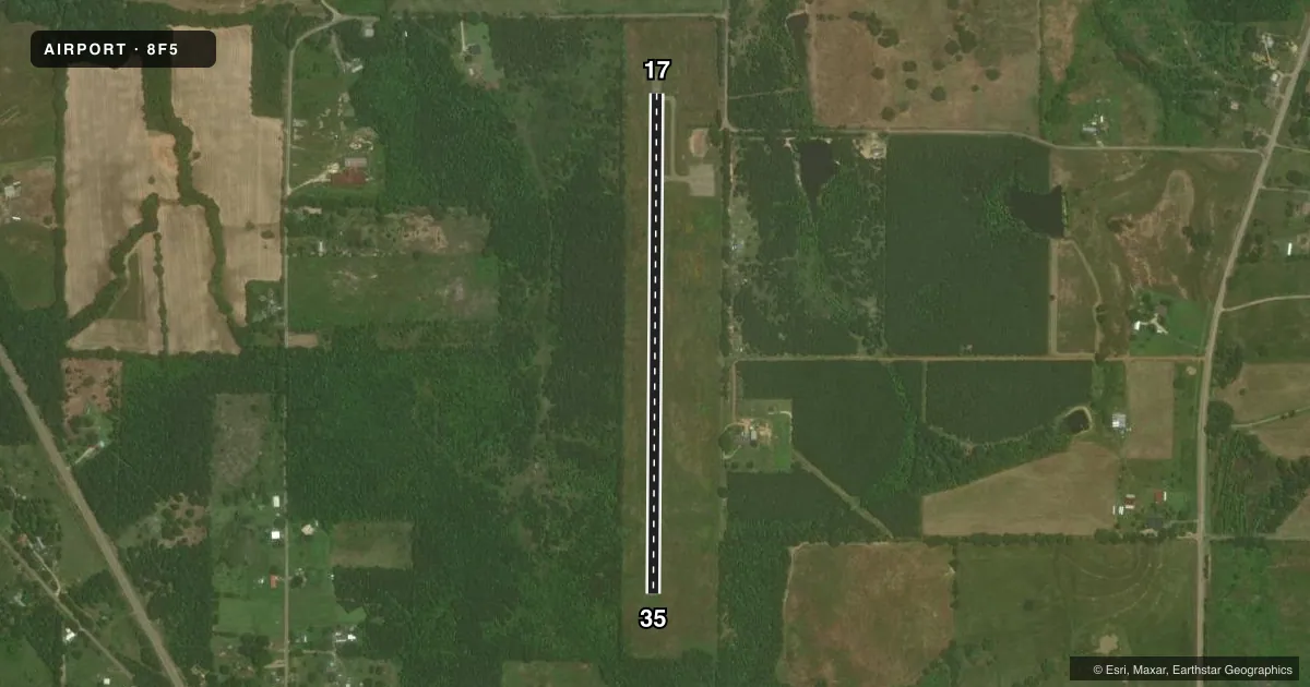
Airport sketch
Runways drawn to scale from FAA survey coordinates, rendered over satellite imagery. Not for navigation.
Approaches & charts
Services on the field
Fuel grades, oxygen, maintenance, ramp storage and lighting — as declared to the FAA by the airport operator.
Fuel & services
- Fuel
- Not available
Ramp & ground
- Transient storage
- Not published
- Landing fee
- No fee published
- Customs
- Not available
- Wind indicator
- Yes
- Segmented circle
- Yes
Fuel & FBOs
Cheapest 100LL and Jet A on the field and nearby. Always confirm with the FBO before taxi.
Airport notes
Surface conditions, obstructions, local procedures, lighting outages and other notes published with each FAA cycle.
General notes
- NO LINE OF SIGHT BTN RWY ENDS.
- NO BLDGS, NO FACS.
- FOR CD CTC FORT WORTH ARTCC AT 817-858-7584.
- NO AIRFRAME OR POWERPLANT RPRS AVBL.
Other notes
- MANAGERCOUNTY COMMISSIONER.
- 17/35EXTSV CRACKING, LOOSE GRVL & GRASS ON RWY & TWY. RWY CONDS NOT MNT.
VFR map & nearby airports
VFR sectional. Tap any ICAO chip to open that airport.
Key facts · 8F5
Answer card- ICAO
- 8F5
- Name
- GREATER MORRIS COUNTY
- Location
- DAINGERFIELD, TEXAS
- Elevation
- 402 ft MSL
- Traffic pattern altitude
- 1,402 ft MSL (1,000 AGL)
- Control tower
- Non-towered (use CTAF)
- Total runways
- 1
- Longest runway
- 17/35 · 3,000 ft
- Published ILS approaches
- 0
- Published frequencies
- 1
- Magnetic variation
- 5°
- Current flight rules
- VFR
- Current wind
- 190° at 3 kt
- Favored runway now
- RWY 17
Greater Morris County Airport is in Daingerfield, Texas. The field elevation is 402 ft MSL. It has one runway, 17/35, which is 3,000 ft long and asphalt. There is no control tower. CTAF is 122.9. No ILS approaches are published here.
The pattern altitude is not published. Use the standard 1,000 ft AGL pattern unless the current Chart Supplement says otherwise. There are no buildings and no facilities at this airport. No on-field FBOs are listed. There is also no airframe or powerplant repair service on the field. For clearance delivery, contact Fort Worth ARTCC at 817-858-7584.
This is a non-towered field with limited infrastructure. The runway condition note matters. FAA remarks say there is extensive cracking, loose gravel and grass on the runway and taxiway. Runway conditions are not maintained. There is also no line of sight between runway ends. Keep your traffic calls tight. Expect limited visual confirmation of opposite-end traffic. Check the current FAA Chart Supplement before you go. That is the best source for any updated remarks, pattern notes, or operational changes.