METAR & TAF KOSA
Current METAR
Observed 22:35Z
KOSA 262235Z AUTO 14010KT 10SM CLR 36/20 A2995 RMK AO2 T03640196
- Wind
- 140° @ 10 kt
- Visibility
- 10 SM
- Temp / Dew
- 36°C / 20°C
- Altimeter
- 29.95 inHg
- Clouds
- CLR
- Density alt
- 2,934 ft
- Ceiling
- Unlimited
- Rules
- VFR
Airport info & contacts
Manager on record, flight service, ARTCC, attendance schedule and pattern altitude — published by the FAA and refreshed every 28 days.
Location
- From city
- 3 NM S
- VFR sectional
- MEMPHIS
- ARTCC
- ZFW · FORT WORTH
- NOTAM facility
- OSA (NOTAM-D)
Airport manager
- Name
- PAUL HENDERSON
- Phone
- 903-575-4020
- Address
- 501 MIKE HALL PARKWAY, MOUNT PLEASANT TX 75455
Flight service · Hours
- FSS FTW
- FORT WORTH1-800-WX-BRIEF
- Attendance
- 0700-1800
Frequencies
Tap any row to copy the frequency to your clipboard.
Runways & pattern
Full pagePattern entry · RWY 17
LEFT TRAFFICRunway end performance
| End | TORA | TODA | ASDA | LDA | VGSI | Approach lights | Obstruction |
|---|---|---|---|---|---|---|---|
| 17 | — | — | — | — | PAPI 4-box left(3°) | — | — |
| 35 | — | — | — | — | PAPI 4-box left(3°) | — | 80', trees, 2300' from thr, 30' R of cntrln, slope 26 |
Declared distances in feet. TORA = takeoff run available, TODA = takeoff distance, ASDA = accelerate-stop, LDA = landing distance.
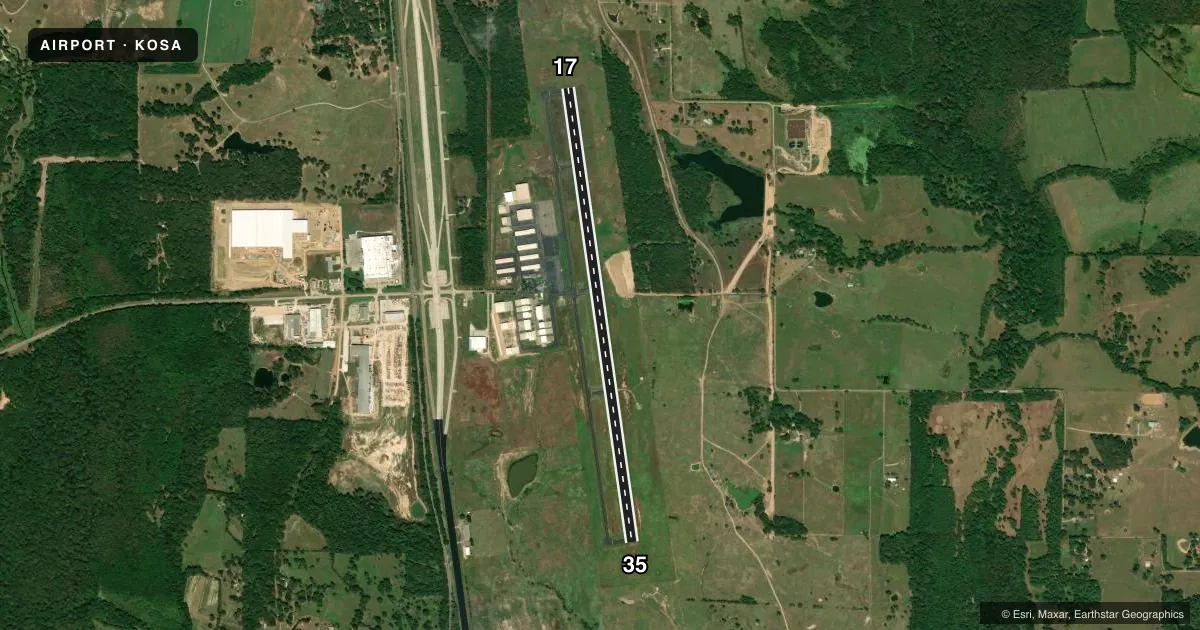
Airport sketch
Runways drawn to scale from FAA survey coordinates, rendered over satellite imagery. Not for navigation.
Approaches & charts
Services on the field
Fuel grades, oxygen, maintenance, ramp storage and lighting — as declared to the FAA by the airport operator.
Fuel & services
- Fuel
- 100LLA
- Airframe repair
- Major
- Power plant repair
- Major
Ramp & ground
- Transient storage
- Tie-down
- Hangar
- Lighting schedule
- SEE RMK
- Beacon schedule
- SS-SR
- Beacon
- White / Green (civil land)(WG)
- Wind indicator
- Lighted
- Segmented circle
- Yes
Fuel & FBOs
Cheapest 100LL and Jet A on the field and nearby. Always confirm with the FBO before taxi.
Airport notes
Surface conditions, obstructions, local procedures, lighting outages and other notes published with each FAA cycle.
General notes
- DEER & WILDLIFE ON & INVOF ARPT.
- NO LINE OF SIGHT BETWEEN RWY ENDS.
- FOR CD CTC FORT WORTH ARTCC AT 817-858-7584.
Lighting notes
- REIL RWY 17 & 35, MIRL RWY 17/35 PRE-SET ON LOW SS-SR. TO ACTVT DAYTIME & INCR INTST - CTAF. PAPI RWY 17 & 35 OPR CONSLY.
Fuel notes
- 100LLFOR JET A AFT HRS CALL 903-575-4004. 100LL AVBL 24 HRS SELF SERV.
Approach & departure obstructions
- 17MKGS DISCOLORED.
- 35MKGS DISCOLORED.
- H1MKGS DISCOLORED.
- H159 FT BCN 285 FT W AND 33 FT BLDG 256 FT W.
Other notes
- MANAGERPHENDERSON@MPCITY.ORG
VFR map & nearby airports
VFR sectional. Tap any ICAO chip to open that airport.
Key facts · KOSA
Answer card- ICAO
- KOSA
- Name
- MOUNT PLEASANT RGNL
- Location
- MOUNT PLEASANT, TEXAS
- Elevation
- 364.2 ft MSL
- Traffic pattern altitude
- 1,364.2 ft MSL (1,000 AGL)
- Control tower
- Non-towered (use CTAF)
- Total runways
- 1
- Longest runway
- 17/35 · 6,004 ft
- Published ILS approaches
- 0
- Published frequencies
- 2
- Magnetic variation
- 4°
- Current flight rules
- VFR
- Current wind
- 140° at 10 kt
- Favored runway now
- RWY 17
Mount Pleasant Rgnl is in Mount Pleasant, Texas. The field elevation is 364.2 ft MSL. It has one runway, 17/35, which is 6,004 ft long. There is no control tower. CTAF and UNICOM are both 122.7.
No ILS approaches are published here. Pattern altitude is not published, so a light piston pilot should verify the current pattern setup before arrival. The published remarks also note that runway 17/35 lighting is preset low from sunset to sunrise. Use the CTAF to raise the intensity in daylight. PAPI is listed as operating continuously on both ends.
There are no on-field FBOs listed in the facts. 100LL is available 24 hours self-service. For Jet A after hours, call the number in the Chart Supplement or contact the airport operator before you go. The airport also notes deer and wildlife in the area. There is no line of sight between runway ends, so plan your taxi and runway checks with that in mind. Markings on runway 17 and runway 35 are discolored. If you need clearance delivery, Fort Worth ARTCC is the published contact.