METAR & TAF KLBR
KLBR does not publish a METAR.
Showing the nearest reporting station: KPRX (COX FLD) · 19.5 NM away. Conditions at KLBR may differ.
METAR · KPRX
Observed 12:55Z
KPRX 271255Z AUTO 18006KT 10SM CLR 27/22 A2997 RMK AO2 SLP142 T02670222
- Wind
- 180° @ 6 kt
- Visibility
- 10 SM
- Temp / Dew
- 27°C / 22°C
- Altimeter
- 29.97 inHg
- Clouds
- CLR
- Density alt
- 1,924 ft
- Ceiling
- Unlimited
- Rules
- VFR
Airport info & contacts
Manager on record, flight service, ARTCC, attendance schedule and pattern altitude — published by the FAA and refreshed every 28 days.
Location
- From city
- 3 NM SW
- VFR sectional
- DALLAS-FT WORTH
- ARTCC
- ZFW · FORT WORTH
- NOTAM facility
- LBR (NOTAM-D)
Airport manager
- Name
- DAN HALLEY
- Phone
- 903-631-9531
- Address
- 550 S AUSTIN, AVERY TX 75554
Flight service · Hours
- FSS FTW
- FORT WORTH1-800-WX-BRIEF
- Attendance
- IREG
Frequencies
Tap any row to copy the frequency to your clipboard.
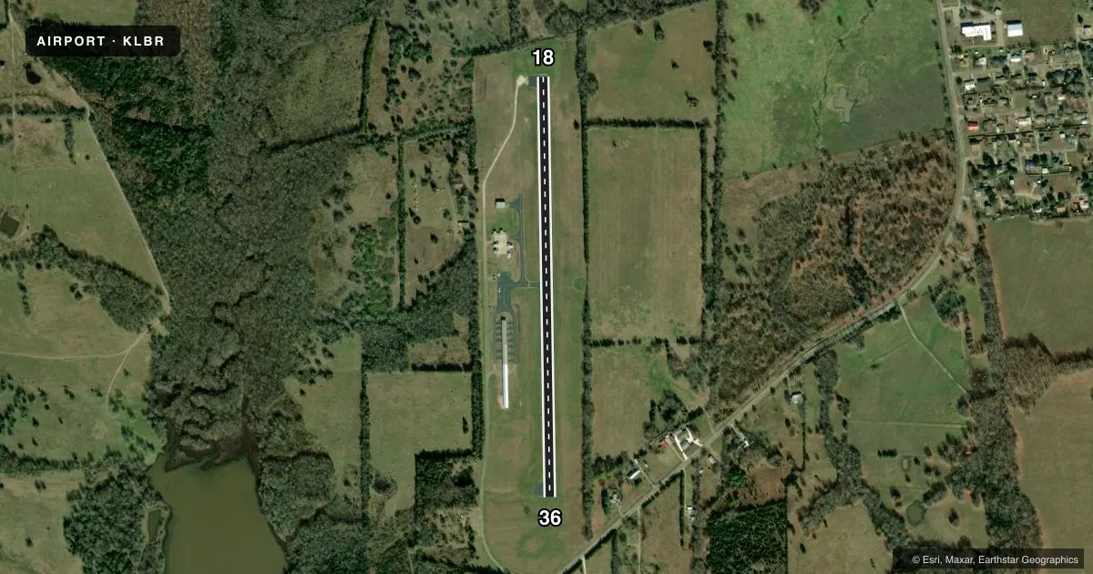
Runways & pattern
Full pagePattern entry · RWY 18
LEFT TRAFFICRunway end performance
| End | TORA | TODA | ASDA | LDA | VGSI | Approach lights | Obstruction |
|---|---|---|---|---|---|---|---|
| 18 | — | — | — | — | — | — | 35', trees, 201' from thr, 85' R of cntrln, slope 0 |
| 36 | — | — | — | — | — | — | 44', trees, 642' from thr, 85' R of cntrln, slope 10 |
Declared distances in feet. TORA = takeoff run available, TODA = takeoff distance, ASDA = accelerate-stop, LDA = landing distance.
Airport sketch
Runways drawn to scale from FAA survey coordinates, rendered over satellite imagery. Not for navigation.
Approaches & charts
Services on the field
Fuel grades, oxygen, maintenance, ramp storage and lighting — as declared to the FAA by the airport operator.
Fuel & services
- Fuel
- Not available
- Oxygen (bottled)
- Not available
- Oxygen (bulk)
- Not available
- Airframe repair
- Not available
- Power plant repair
- Not available
- Other services
- AGRI,INSTR,RNTL
Ramp & ground
- Transient storage
- Tie-down
- Hangar
- Landing fee
- No fee published
- Customs
- Not available
- Lighting schedule
- SS-SR
- Beacon schedule
- SS-SR
- Beacon
- White / Green (civil land)(WG)
- Wind indicator
- Lighted
- Segmented circle
- Yes
Fuel & FBOs
Cheapest 100LL and Jet A on the field and nearby. Always confirm with the FBO before taxi.
Airport notes
Surface conditions, obstructions, local procedures, lighting outages and other notes published with each FAA cycle.
General notes
- FOR CD CTC FORT WORTH ARTCC AT 817-858-7584.
Approach & departure obstructions
- 1823 FT TREES, 180-199 FT DSTC, 100 R.
VFR map & nearby airports
VFR sectional. Tap any ICAO chip to open that airport.
Key facts · KLBR
Answer card- ICAO
- KLBR
- Name
- CLARKSVILLE/RED RIVER CTY-J D TRISSELL FLD
- Location
- CLARKSVILLE, TEXAS
- Elevation
- 440 ft MSL
- Traffic pattern altitude
- 1,440 ft MSL (1,000 AGL)
- Control tower
- Non-towered (use CTAF)
- Total runways
- 1
- Longest runway
- 18/36 · 3,000 ft
- Published ILS approaches
- 0
- Published frequencies
- 1
- Magnetic variation
- 2°
- Current flight rules
- VFR
- Current wind
- 180° at 6 kt
- Favored runway now
- RWY 18
KLBR is in Clarksville, Texas. The field elevation is 440 ft MSL. It has one runway, 18/36, which is 3,000 ft long with an asphalt surface. There is no control tower. CTAF is 122.9.
No ILS approaches are published here. Pattern altitude is not published, so use the standard 1,000 ft AGL for light piston operations unless the current FAA Chart Supplement says otherwise. The airport sits in a simple single-runway layout, so arrivals are straightforward. Runway 18 has a published tree obstruction near the departure end. That is worth keeping in mind on takeoff and landing. For clearance delivery, contact Fort Worth ARTCC at 817-858-7584.
There are no on-field FBOs listed in the facts. Plan on checking with the airport operator or calling ahead for current services before you go. The runway headings are magnetic, with 18 at 179° and 36 at 359°. If you are flying in from outside the area, verify current airspace and any local procedures in the FAA Chart Supplement before departure.