METAR & TAF 4O4
Current METAR
Observed 13:35Z
K4O4 271335Z AUTO VRB03KT 8SM CLR 28/23 A2999 RMK AO2
- Wind
- VAR @ 3 kt
- Visibility
- 8 SM
- Temp / Dew
- 28°C / 23°C
- Altimeter
- 29.99 inHg
- Clouds
- CLR
- Density alt
- 2,058 ft
- Ceiling
- Unlimited
- Rules
- VFR
Airport info & contacts
Manager on record, flight service, ARTCC, attendance schedule and pattern altitude — published by the FAA and refreshed every 28 days.
Location
- From city
- 2 NM NW
- VFR sectional
- MEMPHIS
- ARTCC
- ZFW · FORT WORTH
- NOTAM facility
- 4O4 (NOTAM-D)
Airport manager
- Name
- TORAN FRENCH
- Phone
- 580-286-3558
- Address
- 2907 NW. AIRPORT RD., IDABEL OK 74745
Flight service · Hours
- FSS MLC
- MC ALESTER1-800-WX-BRIEF
- Attendance
- MON-FRI · 0700-1600
Frequencies
Tap any row to copy the frequency to your clipboard.
Runways & pattern
Full pagePattern entry · RWY 02
LEFT TRAFFICRunway end performance
| End | TORA | TODA | ASDA | LDA | VGSI | Approach lights | Obstruction |
|---|---|---|---|---|---|---|---|
| 02 | — | — | — | — | PAPI 4-box left(3°) | — | — |
| 20 | — | — | — | — | PAPI 4-box left(3°) | ODALS | 7', trees, 294' from thr, 90' R of cntrln, slope 13 |
Declared distances in feet. TORA = takeoff run available, TODA = takeoff distance, ASDA = accelerate-stop, LDA = landing distance.
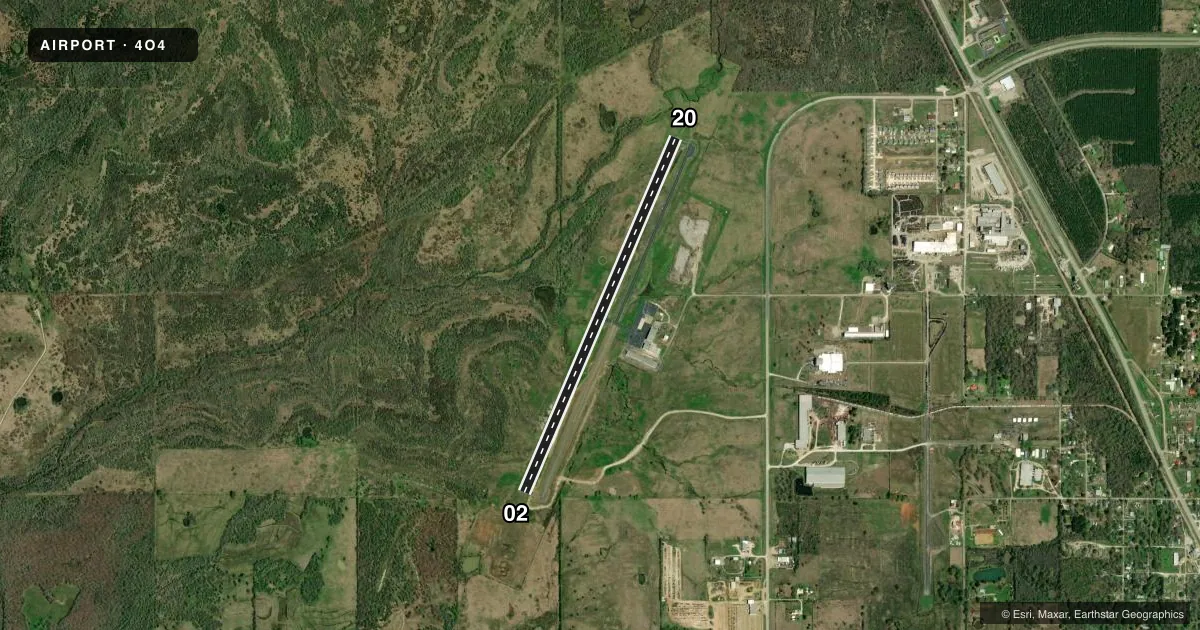
Airport sketch
Runways drawn to scale from FAA survey coordinates, rendered over satellite imagery. Not for navigation.
Approaches & charts
Services on the field
Fuel grades, oxygen, maintenance, ramp storage and lighting — as declared to the FAA by the airport operator.
Fuel & services
- Fuel
- 100LLA+
- Airframe repair
- Not available
- Power plant repair
- Major
- Other services
- AMB
Ramp & ground
- Transient storage
- Tie-down
- Hangar
- Lighting schedule
- SEE RMK
- Beacon schedule
- SS-SR
- Beacon
- White / Green (civil land)(WG)
- Wind indicator
- Lighted
- Segmented circle
- Yes
Fuel & FBOs
Cheapest 100LL and Jet A on the field and nearby. Always confirm with the FBO before taxi.
Airport notes
Surface conditions, obstructions, local procedures, lighting outages and other notes published with each FAA cycle.
General notes
- FOR CD CTC FORT WORTH ARTCC AT 817-858-7584.
Lighting notes
- ACTVT ODALS RWY 20; REIL RWY 02; PAPI RWY 02 & 20; MIRL RWY 02/20 - CTAF.
Other notes
- PRVDD EXISTING IDABEL MUNI ARPT IS CLSD PRIOR TO OPNS STARTING AT THE NE MC CURTAIN ARPT.
- MANAGERCODE ENFORCEMENT
VFR map & nearby airports
VFR sectional. Tap any ICAO chip to open that airport.
Key facts · 4O4
Answer card- ICAO
- 4O4
- Name
- MC CURTAIN COUNTY RGNL
- Location
- IDABEL, OKLAHOMA
- Elevation
- 471.6 ft MSL
- Traffic pattern altitude
- 1,471.6 ft MSL (1,000 AGL)
- Control tower
- Non-towered (use CTAF)
- Total runways
- 1
- Longest runway
- 02/20 · 5,002 ft
- Published ILS approaches
- 0
- Published frequencies
- 2
- Magnetic variation
- 3°
- Current flight rules
- VFR
- Current wind
- 000° at 3 kt
- Favored runway now
- RWY 02
McCurtain County Regional Airport sits in Idabel, Oklahoma. Field elevation is 471.6 ft MSL. The airport has one runway. Runway 02/20 is 5,002 ft long and paved with asphalt. There is no control tower. CTAF and UNICOM are both 122.8. No ILS approaches are published here.
The published pattern altitude is not listed. For light piston operations, use the standard 1,000 ft AGL unless the current Chart Supplement says otherwise. The field is a good fit for local and regional VFR work. The published remarks also call out runway lighting on both ends, with approach lighting on runway 20 and PAPI on runways 02 and 20. That helps at night or in lower visibility. You should still brief the runway before arrival.
McCurtain County Regional Airport has one on-field FBO. McCurtain County Regional Airport carries 100LL and Jet A. If you need current ramp details, code enforcement guidance, or anything not listed here, call the airport operator or the FBO directly before you go. The remarks also note that clearance delivery is handled through Fort Worth ARTCC at 817-858-7584. Check the current Chart Supplement for any published restrictions before flying in.