METAR & TAF 80F
80F does not publish a METAR.
Showing the nearest reporting station: KHHW (STAN STAMPER MUNI) · 11.0 NM away. Conditions at 80F may differ.
METAR · KHHW
Observed 12:50Z
KHHW 271250Z AUTO 19005KT 10SM CLR 26/21 A2996 RMK AO2
- Wind
- 190° @ 5 kt
- Visibility
- 10 SM
- Temp / Dew
- 26°C / 21°C
- Altimeter
- 29.96 inHg
- Clouds
- CLR
- Density alt
- 1,986 ft
- Ceiling
- Unlimited
- Rules
- VFR
Airport info & contacts
Manager on record, flight service, ARTCC, attendance schedule and pattern altitude — published by the FAA and refreshed every 28 days.
Location
- From city
- 3 NM SW
- VFR sectional
- DALLAS-FT WORTH
- ARTCC
- ZFW · FORT WORTH
- NOTAM facility
- MLC (NOTAM-D)
Airport manager
- Name
- MICHAEL TAYLOR
- Phone
- 580-298-5635
- Address
- 100 SE 2ND ST, 100 SW 2ND ST, ANTLERS OK 74523
Flight service · Hours
- FSS MLC
- MC ALESTER1-800-WX-BRIEF
- Attendance
- Unattended
Frequencies
Tap any row to copy the frequency to your clipboard.
Runways & pattern
Full pagePattern entry · RWY 18
LEFT TRAFFICRunway end performance
| End | TORA | TODA | ASDA | LDA | VGSI | Approach lights | Obstruction |
|---|---|---|---|---|---|---|---|
| 18 | — | — | — | — | PAPI 2-box left(3°) | — | 46', tree, 608' from thr, 271' R of cntrln, slope 8 |
| 36 | — | — | — | — | PAPI 2-box left(3°) | — | — |
Declared distances in feet. TORA = takeoff run available, TODA = takeoff distance, ASDA = accelerate-stop, LDA = landing distance.
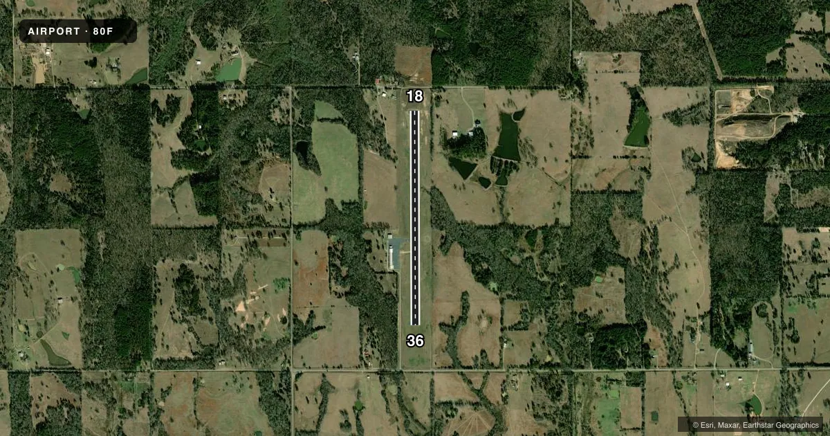
Airport sketch
Runways drawn to scale from FAA survey coordinates, rendered over satellite imagery. Not for navigation.
Approaches & charts
Services on the field
Fuel grades, oxygen, maintenance, ramp storage and lighting — as declared to the FAA by the airport operator.
Fuel & services
- Fuel
- 100LL
- Oxygen (bottled)
- Not available
- Oxygen (bulk)
- Not available
- Airframe repair
- Not available
- Power plant repair
- Not available
- Other services
- INSTR,RNTL
Ramp & ground
- Transient storage
- Tie-down
- Landing fee
- No fee published
- Customs
- Not available
- Lighting schedule
- SEE RMK
- Beacon schedule
- SS-SR
- Beacon
- White / Green (civil land)(WG)
- Wind indicator
- Yes
- Segmented circle
- Yes
Fuel & FBOs
Cheapest 100LL and Jet A on the field and nearby. Always confirm with the FBO before taxi.
Airport notes
Surface conditions, obstructions, local procedures, lighting outages and other notes published with each FAA cycle.
General notes
- FOR CD CTC FORT WORTH ARTCC AT 817-858-7584.
Lighting notes
- ACTVT MIRL RWY 18/36 - CTAF. PAPI RWY 18 & 36 ON CONSLY.
Fuel notes
- 100LLAVBL 24 HR WITH CREDIT CARD.
Approach & departure obstructions
- 18PAPI UNUSBL.
VFR map & nearby airports
VFR sectional. Tap any ICAO chip to open that airport.
Key facts · 80F
Answer card- ICAO
- 80F
- Name
- ANTLERS MUNI
- Location
- ANTLERS, OKLAHOMA
- Elevation
- 576.7 ft MSL
- Traffic pattern altitude
- 1,576.7 ft MSL (1,000 AGL)
- Control tower
- Non-towered (use CTAF)
- Total runways
- 1
- Longest runway
- 18/36 · 4,001 ft
- Published ILS approaches
- 0
- Published frequencies
- 1
- Magnetic variation
- 2°
- Current flight rules
- VFR
- Current wind
- 190° at 5 kt
- Favored runway now
- RWY 18
Antlers Muni sits in Antlers, Oklahoma. Field elevation is 576.7 ft MSL. The airport has one runway. Runway 18/36 is asphalt and 4,001 ft long. There is no control tower. CTAF is 122.9. No ILS approaches are published here.
Pattern altitude is not published. Use 1,000 ft AGL for light piston traffic unless the current Chart Supplement says otherwise. The field is non-towered, so standard CTAF self-announce work applies. Medium intensity runway lights on 18/36 are activated by using the common traffic advisory frequency. The PAPI on runway 18 is unusable. The PAPI on runway 36 is on continuously.
Antlers Municipal Airport is on the field. It carries 100LL. 100LL is available 24 hours with a credit card. For clearance delivery, contact Fort Worth ARTCC at 817-858-7584. If you are planning IFR, remember that no ILS approaches are published. Check the current Chart Supplement before you go for the latest remarks and any changes to lighting or procedures.