METAR & TAF 08F
08F does not publish a METAR.
Showing the nearest reporting station: KADH (ADA RGNL) · 27.2 NM away. Conditions at 08F may differ.
METAR · KADH
Observed 13:15Z
KADH 271315Z AUTO 20006KT 5SM HZ CLR 28/22 A2995 RMK AO2
- Wind
- 200° @ 6 kt
- Visibility
- 5 SM
- Temp / Dew
- 28°C / 22°C
- Altimeter
- 29.95 inHg
- Clouds
- CLR
- Density alt
- 2,288 ft
- Ceiling
- Unlimited
- Rules
- MVFR
Airport info & contacts
Manager on record, flight service, ARTCC, attendance schedule and pattern altitude — published by the FAA and refreshed every 28 days.
Location
- From city
- 1 NM W
- VFR sectional
- DALLAS-FT WORTH
- ARTCC
- ZFW · FORT WORTH
- NOTAM facility
- MLC (NOTAM-D)
Airport manager
- Name
- AARON BLUE
- Phone
- 580-927-3914
- Address
- 1000 MCANALLY RD., COALGATE OK 74538
Flight service · Hours
- FSS MLC
- MC ALESTER1-800-WX-BRIEF
- Attendance
- Unattended
Frequencies
Tap any row to copy the frequency to your clipboard.
Runways & pattern
Full pagePattern entry · RWY 17
LEFT TRAFFICRunway end performance
| End | TORA | TODA | ASDA | LDA | VGSI | Approach lights | Obstruction |
|---|---|---|---|---|---|---|---|
| 17 | — | — | — | — | — | — | 55', tree, 1125' from thr, 138' R of cntrln, slope 16 |
Declared distances in feet. TORA = takeoff run available, TODA = takeoff distance, ASDA = accelerate-stop, LDA = landing distance.
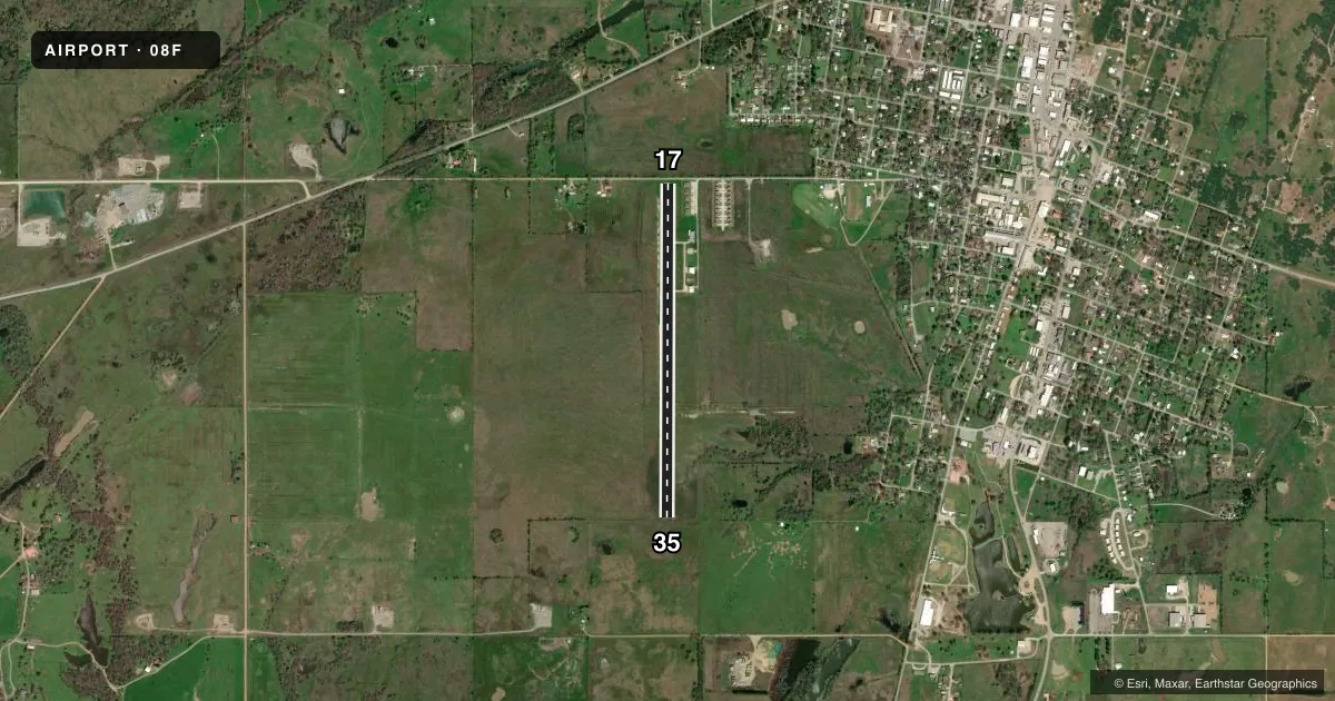
Airport sketch
Runways drawn to scale from FAA survey coordinates, rendered over satellite imagery. Not for navigation.
Approaches & charts
Services on the field
Fuel grades, oxygen, maintenance, ramp storage and lighting — as declared to the FAA by the airport operator.
Fuel & services
- Fuel
- Not available
Ramp & ground
- Transient storage
- Not published
- Landing fee
- No fee published
- Lighting schedule
- SS-SR
- Wind indicator
- Lighted
- Segmented circle
- No
Fuel & FBOs
Cheapest 100LL and Jet A on the field and nearby. Always confirm with the FBO before taxi.
Airport notes
Surface conditions, obstructions, local procedures, lighting outages and other notes published with each FAA cycle.
General notes
- FOR CD CTC FORT WORTH ARTCC AT 817-858-7584.
Runway surface & condition
- 17/35LGTS NSTD - SOLAR 2 FT FM RWY EDGE.
Approach & departure obstructions
- 175 FT FENCE 20 FT FM RWY THR; 15 FT ROAD 42 FT FM RWY THR.
- 354 FT FENCE 45 FT FM THR.
- 17185 FT WATER TWRS 1320 FT FM THR, 350 FT LEFT.
- 17SVRLY FADED.
- 35SVRLY FADED.
- 17NSTD SIZE.
- 35NSTD SIZE.
Other notes
- VFR OPS ONLY.
- 17/35CONC OVERLAY.
VFR map & nearby airports
VFR sectional. Tap any ICAO chip to open that airport.
Key facts · 08F
Answer card- ICAO
- 08F
- Name
- CITY OF COALGATE
- Location
- COALGATE, OKLAHOMA
- Elevation
- 617 ft MSL
- Traffic pattern altitude
- 1,617 ft MSL (1,000 AGL)
- Control tower
- Non-towered (use CTAF)
- Total runways
- 1
- Longest runway
- 17/35 · 3,862 ft
- Published ILS approaches
- 0
- Published frequencies
- 1
- Magnetic variation
- 6°
- Current flight rules
- MVFR
- Current wind
- 200° at 6 kt
- Favored runway now
- RWY 17
City of Coalgate Airport (08F) is in Coalgate, Oklahoma. Field elevation is 617 ft MSL. The airport has one runway. Runway 17/35 is 3,862 ft long with a concrete overlay surface. There is no control tower. CTAF is 122.9. No ILS approaches are published here.
Pattern altitude is not published. Use 1,000 ft AGL for light piston operations unless the current Chart Supplement says otherwise. This field is VFR only. That matters for planning if weather is marginal or if you were counting on an instrument arrival.
The published remarks call out several close-in obstacles. There is a fence near each runway end. There is also a road near the Runway 17 threshold. Runway 17 markings are severely faded and nonstandard size. Runway 35 markings are also severely faded and nonstandard size. The runway lights are nonstandard and solar powered, with lights set close to the runway edge. There are no on-field FBOs listed. Check with the airport operator or the FBO directly by phone before arrival if you need fuel or local services. For clearance delivery, contact Fort Worth ARTCC at 817-858-7584.