METAR & TAF KADH
Current METAR
Observed 13:15Z
KADH 271315Z AUTO 20006KT 5SM HZ CLR 28/22 A2995 RMK AO2
- Wind
- 200° @ 6 kt
- Visibility
- 5 SM
- Temp / Dew
- 28°C / 22°C
- Altimeter
- 29.95 inHg
- Clouds
- CLR
- Density alt
- 2,783 ft
- Ceiling
- Unlimited
- Rules
- MVFR
Airport info & contacts
Manager on record, flight service, ARTCC, attendance schedule and pattern altitude — published by the FAA and refreshed every 28 days.
Location
- From city
- 2 NM N
- VFR sectional
- DALLAS-FT WORTH
- ARTCC
- ZFW · FORT WORTH
- NOTAM facility
- ADH (NOTAM-D)
Airport manager
- Name
- BAILEY KENNEMER
- Phone
- 580-436-8190
- Address
- 300 RAY STOUT BLVD, SUITE A, ADA OK 74820
Flight service · Hours
- FSS MLC
- MC ALESTER1-800-WX-BRIEF
- Attendance
- MON-SAT · 0800-1700
- SUN · 1200-1700
Frequencies
Tap any row to copy the frequency to your clipboard.
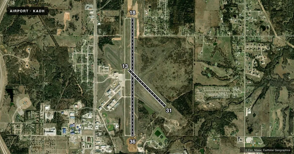
Runways & pattern
Full pagePattern entry · RWY 18
LEFT TRAFFIC| Runway | Heading (°M) | Length | Surface | Traffic |
|---|---|---|---|---|
| 18/36Favored | 177° / 357° | 6,203 ft | ASPH | Standard L |
| 13/31 | 132° / 312° | 2,717 ft | ASPH-CONC | Standard L |
Runway end performance
| End | TORA | TODA | ASDA | LDA | VGSI | Approach lights | Obstruction |
|---|---|---|---|---|---|---|---|
| 18 | — | — | — | — | PAPI 4-box left(3°) | ODALS | 31', trees, 1039' from thr, 54' R of cntrln, slope 27 |
| 36 | — | — | — | — | PAPI 4-box left(3°) | — | 62', trees, 1249' from thr, 335' R of cntrln, slope 16 |
Declared distances in feet. TORA = takeoff run available, TODA = takeoff distance, ASDA = accelerate-stop, LDA = landing distance.
Airport sketch
Runways drawn to scale from FAA survey coordinates, rendered over satellite imagery. Not for navigation.
Approaches & charts
Services on the field
Fuel grades, oxygen, maintenance, ramp storage and lighting — as declared to the FAA by the airport operator.
Fuel & services
- Fuel
- 100LLA+
- Oxygen (bulk)
- HIGH/LOW
- Airframe repair
- Major
- Power plant repair
- Major
- Other services
- AMB,RNTL,SURV
Ramp & ground
- Transient storage
- Tie-down
- Hangar
- Landing fee
- Yes
- Customs
- Not available
- Lighting schedule
- SEE RMK
- Beacon schedule
- SS-SR
- Beacon
- White / Green (civil land)(WG)
- Wind indicator
- Lighted
- Segmented circle
- Yes
Fuel & FBOs
Cheapest 100LL and Jet A on the field and nearby. Always confirm with the FBO before taxi.
Airport notes
Surface conditions, obstructions, local procedures, lighting outages and other notes published with each FAA cycle.
General notes
- FOR CD CTC FORT WORTH ARTCC AT 817-858-7584.
Lighting notes
- ACTVT ODALS RWY 18; REILS RWY 36; MIRL RWY 18/36 - CTAF. PAPI RWY 18 & 36 ON CONSLY.
Fuel notes
- 100LLAFT HR FUEL - 580-235-5279.
Approach & departure obstructions
- 13MARKINGS SVRLY FADED.
- 31MARKINGS SVRLY FADED.
- 36UNUSBL BYD 7 DEGS RIGHT OF CNTRLN.
- 18CLNC SLP TO DISP THLD 22:1.
Other notes
- LNDG FEE FOR ACFT 50000 LBS OR GTR.
- 13/31SVR CRACKING & RAVELING ASPH PTN.
VFR map & nearby airports
VFR sectional. Tap any ICAO chip to open that airport.
Key facts · KADH
Answer card- ICAO
- KADH
- Name
- ADA RGNL
- Location
- ADA, OKLAHOMA
- Elevation
- 1,015.9 ft MSL
- Traffic pattern altitude
- 2,015.9 ft MSL (1,000 AGL)
- Control tower
- Non-towered (use CTAF)
- Total runways
- 2
- Longest runway
- 18/36 · 6,203 ft
- Published ILS approaches
- 0
- Published frequencies
- 2
- Magnetic variation
- 3°
- Current flight rules
- MVFR
- Current wind
- 200° at 6 kt
- Favored runway now
- RWY 18
ADA RGNL sits in Ada, Oklahoma. The field elevation is 1,015.9 ft MSL. It has two runways. The longest is runway 18/36 at 6,203 ft. The airport is non-towered. CTAF and UNICOM are both 122.8.
No ILS approaches are published here. Pattern altitude is not published, so a light piston pilot should plan on the standard 1,000 ft AGL unless the current Chart Supplement says otherwise. Heartland Aviation is on the field. It carries 100LL, Jet A and Jet A Prist. After-hours 100LL is available by calling the number in the Chart Supplement. That matters if you are arriving late or planning a fuel stop outside normal hours.
Runway 18 has approach lighting, PAPI and a displaced-threshold clearance slope note. Runway 36 has REIL, medium-intensity runway lights and PAPI. The published remarks also say runway 13/31 has severe cracking and raveling in patches. Markings on 13 and 31 are severely faded. If you are using the crosswind runway, treat that surface as a maintenance item and brief it before you go. Fort Worth ARTCC handles clearance delivery. Check the current Chart Supplement for any operational changes before departure.