METAR & TAF KADM
Current METAR
Observed 12:50Z
KADM 271250Z 00000KT 10SM CLR 26/21 A2994
- Wind
- 000° @ 0 kt
- Visibility
- 10 SM
- Temp / Dew
- 26°C / 21°C
- Altimeter
- 29.94 inHg
- Clouds
- CLR
- Density alt
- 2,258 ft
- Ceiling
- Unlimited
- Rules
- VFR
Airport info & contacts
Manager on record, flight service, ARTCC, attendance schedule and pattern altitude — published by the FAA and refreshed every 28 days.
Location
- From city
- 10 NM NE
- VFR sectional
- DALLAS-FT WORTH
- ARTCC
- ZFW · FORT WORTH
- NOTAM facility
- ADM (NOTAM-D)
Airport manager
- Name
- DAN LUTTRELL
- Phone
- 580-389-5238
- Address
- 620 GENERAL DR., SUITE 1, ARDMORE OK 73401
Flight service · Hours
- FSS MLC
- MC ALESTER1-800-WX-BRIEF
- Attendance
- MON-FRI · 0700-2300
- SAT-SUN · 0700-1700
Frequencies
Tap any row to copy the frequency to your clipboard.
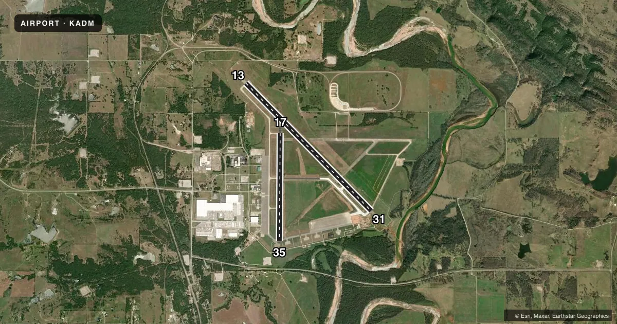
Runways & pattern
Full pagePattern entry · RWY 13
LEFT TRAFFIC| Runway | Heading (°M) | Length | Surface | Traffic |
|---|---|---|---|---|
| 13/31 | 129° / 309° | 9,002 ft | CONC | Standard L |
| 17/35 | 174° / 354° | 5,404 ft | ASPH | Standard L |
Runway end performance
| End | TORA | TODA | ASDA | LDA | VGSI | Approach lights | Obstruction |
|---|---|---|---|---|---|---|---|
| 13 | — | — | — | — | PAPI 4-box left(3°) | — | 72', trees, 2000' from thr, 660' R of cntrln, slope 25 |
| 31 | — | — | — | — | VASI 4-box left(3°) | MALSR | 68', trees, 2075' from thr, 366' R of cntrln, slope 27 |
| 17 | 5,007' | 5,007' | 5,007' | 5,007' | — | — | — |
| 35 | 5,404' | 5,404' | 5,404' | 5,007' | — | — | — |
Declared distances in feet. TORA = takeoff run available, TODA = takeoff distance, ASDA = accelerate-stop, LDA = landing distance.
Airport sketch
Runways drawn to scale from FAA survey coordinates, rendered over satellite imagery. Not for navigation.
Approaches & charts
ILS · 1
Services on the field
Fuel grades, oxygen, maintenance, ramp storage and lighting — as declared to the FAA by the airport operator.
Fuel & services
- Fuel
- 100LLA
- Oxygen (bottled)
- High pressure
- Oxygen (bulk)
- Not available
- Airframe repair
- Major
- Power plant repair
- Major
- Other services
- INSTR,RNTL
Ramp & ground
- Transient storage
- Tie-down
- Hangar
- Landing fee
- No fee published
- Customs
- Not available
- Lighting schedule
- SEE RMK
- Beacon schedule
- SS-SR
- Beacon
- White / Green (civil land)(WG)
- Wind indicator
- Yes
- Segmented circle
- No
Fuel & FBOs
Cheapest 100LL and Jet A on the field and nearby. Always confirm with the FBO before taxi.
Airport notes
Surface conditions, obstructions, local procedures, lighting outages and other notes published with each FAA cycle.
General notes
- FOR CD IF UNA TO CTC ON FSS FREQ, CTC FORT WORTH ARTCC AT 817-858-7584.
Lighting notes
- WHEN ATCT CLSD ACTVT MALSR RWY 31; HIRL RWY 13/31 - CTAF; MIRL RWY 17/35 ON DUSK-DAWN.
Other notes
- CONSTRUCTED PRIOR TO AIRSPACE RQRMTS.
- OWNERARPT OPERD BY ARDMORE DVLPMT AUTH 580-389-5238.
VFR map & nearby airports
VFR sectional. Tap any ICAO chip to open that airport.
Key facts · KADM
Answer card- ICAO
- KADM
- Name
- ARDMORE MUNI
- Location
- ARDMORE, OKLAHOMA
- Elevation
- 776.7 ft MSL
- Traffic pattern altitude
- 1,776.7 ft MSL (1,000 AGL)
- Control tower
- Towered · 0700-2300 MON-FRI; 0700-1700 SAT-SUN
- Total runways
- 2
- Longest runway
- 13/31 · 9,002 ft
- Published ILS approaches
- 1
- Published frequencies
- 8
- Magnetic variation
- 6°
- Current flight rules
- VFR
- Current wind
- 000° at 0 kt
- Favored runway now
- –
Ardmore Muni sits in Ardmore, Oklahoma. Field elevation is 776.7 ft MSL. The airport has two runways. The longest is runway 13/31 at 9,002 ft. Runway 17/35 is 5,404 ft. The field is towered. Tower hours are 0700-2300 Monday through Friday. Weekend hours are 0700-1700. An ILS is published for runway 31. Pattern altitude is not published, so use 1,000 ft AGL for light piston traffic unless the current Chart Supplement says otherwise.
SBA The Line Shack is on the field. It carries 100LL and Jet A Prist. The airport is operated by the Ardmore Development Authority. If you need clearance delivery and cannot raise flight service, the published remark says to contact Fort Worth ARTCC. That is useful to have before departure. The lighting setup also matters here. When the tower is closed, runway 31 approach lighting can be activated. High intensity runway lights for 13 and 31 are tied to CTAF control. Runway 17/35 medium intensity lights run from dusk to dawn.
For a first-time arrival, plan for a controlled airport with published tower hours and one ILS runway. The field was constructed before current airspace requirements. Check the current sectional or the current FAA Chart Supplement for the airspace picture before you go.