METAR & TAF F32
F32 does not publish a METAR.
Showing the nearest reporting station: KADM (ARDMORE MUNI) · 22.6 NM away. Conditions at F32 may differ.
METAR · KADM
Observed 15:50Z
KADM 271550Z 21007KT 10SM CLR 32/22 A2994
- Wind
- 210° @ 7 kt
- Visibility
- 10 SM
- Temp / Dew
- 32°C / 22°C
- Altimeter
- 29.94 inHg
- Clouds
- CLR
- Density alt
- 3,201 ft
- Ceiling
- Unlimited
- Rules
- VFR
Airport info & contacts
Manager on record, flight service, ARTCC, attendance schedule and pattern altitude — published by the FAA and refreshed every 28 days.
Location
- From city
- 2 NM NE
- VFR sectional
- DALLAS-FT WORTH
- ARTCC
- ZFW · FORT WORTH
- NOTAM facility
- MLC (NOTAM-D)
Airport manager
- Name
- SALLY JANTZ
- Phone
- 580-229-1283
- Address
- PO BOX 926, HEALDTON OK 73438
Flight service · Hours
- FSS MLC
- MC ALESTER1-800-WX-BRIEF
- Attendance
- Unattended
Frequencies
Tap any row to copy the frequency to your clipboard.
Runways & pattern
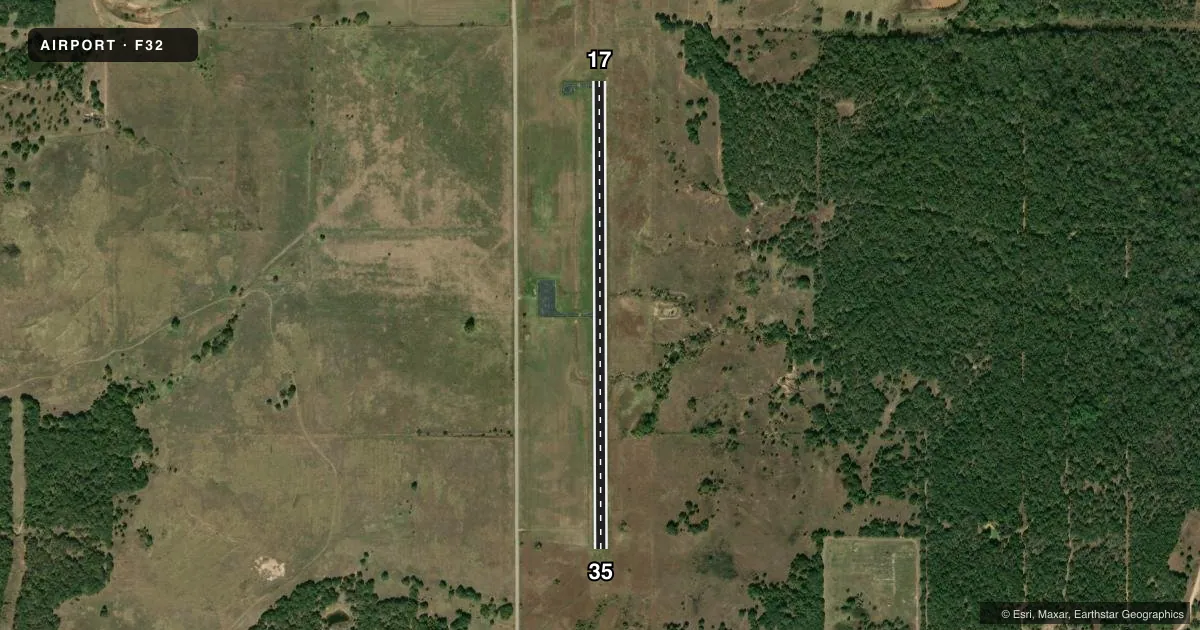
Full pagePattern entry · RWY 17
LEFT TRAFFICAirport sketch
Runways drawn to scale from FAA survey coordinates, rendered over satellite imagery. Not for navigation.
Approaches & charts
Services on the field
Fuel grades, oxygen, maintenance, ramp storage and lighting — as declared to the FAA by the airport operator.
Fuel & services
- Fuel
- Not available
- Oxygen (bottled)
- Not available
- Oxygen (bulk)
- Not available
- Airframe repair
- Not available
- Power plant repair
- Not available
Ramp & ground
- Transient storage
- Tie-down
- Landing fee
- No fee published
- Customs
- Not available
- Wind indicator
- Yes
- Segmented circle
- No
Fuel & FBOs
Cheapest 100LL and Jet A on the field and nearby. Always confirm with the FBO before taxi.
Airport notes
Surface conditions, obstructions, local procedures, lighting outages and other notes published with each FAA cycle.
General notes
- DAYLIGHT OPERATIONS ONLY.
- FOR CD CTC FORT WORTH ARTCC AT 817-858-7584.
Other notes
- PRIOR TO 1958.
- MANAGERCITY MANAGER.
VFR map & nearby airports
VFR sectional. Tap any ICAO chip to open that airport.
Key facts · F32
Answer card- ICAO
- F32
- Name
- HEALDTON MUNI
- Location
- HEALDTON, OKLAHOMA
- Elevation
- 955.9 ft MSL
- Traffic pattern altitude
- 1,955.9 ft MSL (1,000 AGL)
- Control tower
- Non-towered (use CTAF)
- Total runways
- 1
- Longest runway
- 17/35 · 3,020 ft
- Published ILS approaches
- 0
- Published frequencies
- 1
- Magnetic variation
- 7°
- Current flight rules
- VFR
- Current wind
- 210° at 7 kt
- Favored runway now
- RWY 17
Healdton Muni sits in Healdton, Oklahoma. Field elevation is 955.9 ft MSL. The airport has one runway. Runway 17/35 is 3,020 ft long with an asphalt surface. No control tower is published here, so use CTAF 122.9 for local traffic calls. No ILS approaches are published. Pattern altitude is not published, so plan on the standard 1,000 ft AGL for light piston operations unless the current Chart Supplement says otherwise.
This is a daylight operations only field. That matters for arrival planning, especially if you are coming in late or trying to depart near sunset. For clearance delivery, contact Fort Worth ARTCC at 817-858-7584. The published remarks also note the airport manager is the city manager. There are no on-field FBOs listed, so verify fuel and ramp details with the airport operator before you go. If you need current operational details, check the current FAA Chart Supplement or call the airport operator directly. For a first trip, treat this as a small non-towered airport with limited published instrument support. Review the runway alignment, local traffic flow and daylight timing before you launch.