METAR & TAF 1F4
1F4 does not publish a METAR.
Showing the nearest reporting station: KADM (ARDMORE MUNI) · 14.3 NM away. Conditions at 1F4 may differ.
METAR · KADM
Observed 17:50Z
KADM 261750Z VRB05KT 10SM CLR 29/16 A2999
- Wind
- VAR @ 5 kt
- Visibility
- 10 SM
- Temp / Dew
- 29°C / 16°C
- Altimeter
- 29.99 inHg
- Clouds
- CLR
- Density alt
- 2,697 ft
- Ceiling
- Unlimited
- Rules
- VFR
Airport info & contacts
Manager on record, flight service, ARTCC, attendance schedule and pattern altitude — published by the FAA and refreshed every 28 days.
Location
- From city
- 3 NM NW
- VFR sectional
- DALLAS-FT WORTH
- ARTCC
- ZFW · FORT WORTH
- NOTAM facility
- MLC (NOTAM-D)
Airport manager
- Name
- DAVID MCDANIEL
- Phone
- 580-795-4017
- Address
- CITY HALL, 201 E. OVERTON, MADILL OK 73446
Flight service · Hours
- FSS MLC
- MC ALESTER1-800-WX-BRIEF
- Attendance
- Unattended
Frequencies
Tap any row to copy the frequency to your clipboard.
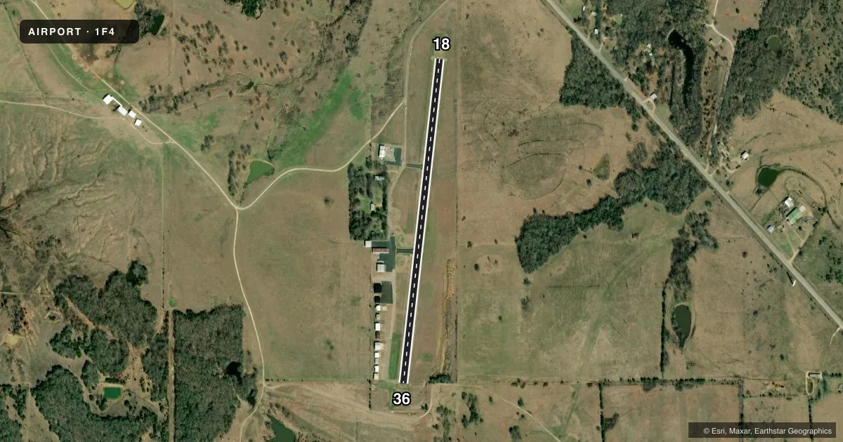
Runways & pattern
Full pagePattern entry · RWY 36
LEFT TRAFFICAirport sketch
Runways drawn to scale from FAA survey coordinates, rendered over satellite imagery. Not for navigation.
Approaches & charts
Services on the field
Fuel grades, oxygen, maintenance, ramp storage and lighting — as declared to the FAA by the airport operator.
Fuel & services
- Fuel
- Not available
- Oxygen (bottled)
- Not available
- Oxygen (bulk)
- Not available
- Airframe repair
- Major
- Power plant repair
- Major
- Other services
- INSTR
Ramp & ground
- Transient storage
- Tie-down
- Landing fee
- No fee published
- Customs
- Not available
- Lighting schedule
- SEE RMK
- Beacon schedule
- SS-SR
- Beacon
- White / Green (civil land)(WG)
- Wind indicator
- Lighted
- Segmented circle
- Yes
Fuel & FBOs
Cheapest 100LL and Jet A on the field and nearby. Always confirm with the FBO before taxi.
Airport notes
Surface conditions, obstructions, local procedures, lighting outages and other notes published with each FAA cycle.
General notes
- +1694 FT TWR 6.2 MI SOUTH OF RY 36 END.
- FOR CD CTC FORT WORTH ARTCC AT 817-858-7584.
Lighting notes
- MIRL RY 18/36 PRESET MED INTENSITY DUSK-0000. AFTER 0000 ACTVT - CTAF.
Other notes
- THIS AIRPORT HAS BEEN SURVEYED BY THE NATIONAL GEODETIC SURVEY.
VFR map & nearby airports
VFR sectional. Tap any ICAO chip to open that airport.
Key facts · 1F4
Answer card- ICAO
- 1F4
- Name
- MADILL MUNI
- Location
- MADILL, OKLAHOMA
- Elevation
- 890 ft MSL
- Traffic pattern altitude
- 1,890 ft MSL (1,000 AGL)
- Control tower
- Non-towered (use CTAF)
- Total runways
- 1
- Longest runway
- 18/36 · 3,005 ft
- Published ILS approaches
- 0
- Published frequencies
- 1
- Magnetic variation
- 6°
- Current flight rules
- VFR
- Current wind
- 000° at 5 kt
- Favored runway now
- RWY 36
Madill Muni sits in Madill, Oklahoma. Field elevation is 890 ft MSL. The airport has one runway. Runway 18/36 is 3,005 ft long with asphalt pavement. There is no control tower. CTAF is 122.9.
No ILS approaches are published here. Pattern altitude is not published, so use the standard 1,000 ft AGL for light piston operations unless the current Chart Supplement says otherwise. The field has been surveyed by the National Geodetic Survey. Medium intensity runway lights on 18/36 are preset from dusk to midnight. After midnight, activate the lights on the CTAF.
A tower is located 6.2 miles south of the runway 36 end. That is worth keeping in mind on departure and arrival planning. For clearance delivery, contact Fort Worth ARTCC at 817-858-7584. No on-field FBOs are listed, so verify current services with the airport operator or call the field directly before arrival.