METAR & TAF 3T0
3T0 does not publish a METAR.
Showing the nearest reporting station: KGYI (NORTH TEXAS RGNL/PERRIN FLD) · 10.1 NM away. Conditions at 3T0 may differ.
METAR · KGYI
Observed 03:35Z
KGYI 270335Z AUTO 15010KT 10SM CLR 30/19 A2995 RMK AO2 T03040191 $
- Wind
- 150° @ 10 kt
- Visibility
- 10 SM
- Temp / Dew
- 30°C / 19°C
- Altimeter
- 29.95 inHg
- Clouds
- CLR
- Density alt
- 2,556 ft
- Ceiling
- Unlimited
- Rules
- VFR
Airport info & contacts
Manager on record, flight service, ARTCC, attendance schedule and pattern altitude — published by the FAA and refreshed every 28 days.
Location
- From city
- 3 NM N
- VFR sectional
- DALLAS-FT WORTH
- ARTCC
- ZFW · FORT WORTH
- NOTAM facility
- FTW (NOTAM-D)
Airport manager
- Name
- KRIS WORSTELL
- Phone
- 903-523-4222
- Address
- CEDAR MILLS MARINA, 500 HARBOUR VIEW, GORDONVILLE TX 76245
Flight service · Hours
- FSS FTW
- FORT WORTH1-800-WX-BRIEF
- Attendance
- Unattended
Frequencies
Tap any row to copy the frequency to your clipboard.
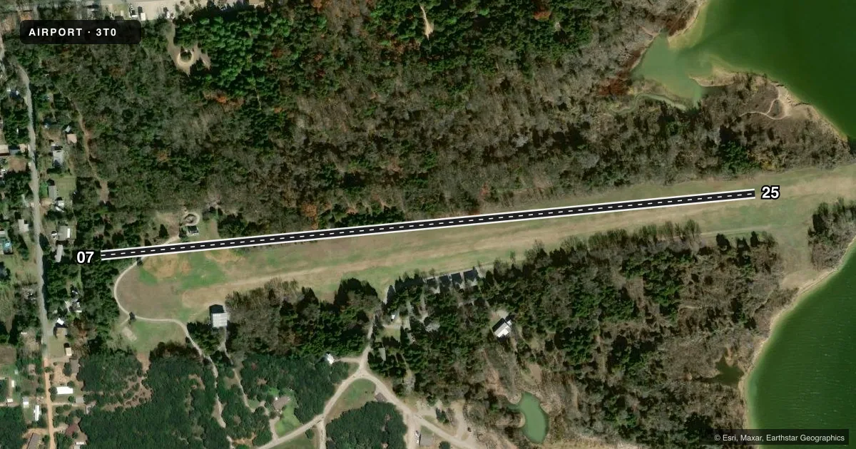
Runways & pattern
Full pagePattern entry · RWY 07
LEFT TRAFFICRunway end performance
| End | TORA | TODA | ASDA | LDA | VGSI | Approach lights | Obstruction |
|---|---|---|---|---|---|---|---|
| 07 | — | — | — | — | — | — | 50', trees, 442' from thr, 95' R of cntrln, slope 8 |
| 25 | — | — | — | — | — | — | tree, slope 50 |
Declared distances in feet. TORA = takeoff run available, TODA = takeoff distance, ASDA = accelerate-stop, LDA = landing distance.
Airport sketch
Runways drawn to scale from FAA survey coordinates, rendered over satellite imagery. Not for navigation.
Approaches & charts
Services on the field
Fuel grades, oxygen, maintenance, ramp storage and lighting — as declared to the FAA by the airport operator.
Fuel & services
- Fuel
- Not available
Ramp & ground
- Transient storage
- Tie-down
- Wind indicator
- Yes
- Segmented circle
- Yes
Fuel & FBOs
Cheapest 100LL and Jet A on the field and nearby. Always confirm with the FBO before taxi.
Airport notes
Surface conditions, obstructions, local procedures, lighting outages and other notes published with each FAA cycle.
General notes
- 40 FT TREES 75 FT N & 80 FT TREES 90 FT S OF RWY 25 CNTRLN.
- FOR CD CTC FORT WORTH ARTCC AT 817-858-7584.
- WILDLIFE ON AND INVOF ARPT.
- RWY 25 END 70 FT FM LAKE, 10 FT DROP OFF.
Other notes
- 07/25RWY SLOPES DOWN 24 FT FM W TO E TWD LAKE.
VFR map & nearby airports
VFR sectional. Tap any ICAO chip to open that airport.
Key facts · 3T0
Answer card- ICAO
- 3T0
- Name
- CEDAR MILLS
- Location
- GORDONVILLE, TEXAS
- Elevation
- 640 ft MSL
- Traffic pattern altitude
- 1,640 ft MSL (1,000 AGL)
- Control tower
- Non-towered (use CTAF)
- Total runways
- 1
- Longest runway
- 07/25 · 3,000 ft
- Published ILS approaches
- 0
- Published frequencies
- 1
- Magnetic variation
- 6°
- Current flight rules
- VFR
- Current wind
- 150° at 10 kt
- Favored runway now
- RWY 07
Cedar Mills (3T0) is in Gordonville, Texas. The field elevation is 640 ft MSL. It has one runway. Runway 07/25 is 3,000 ft of turf, which makes the longest available landing distance 3,000 ft. There is no control tower. CTAF is 122.9. No ILS approaches are published here.
The pattern altitude is not published. Use the standard 1,000 ft AGL pattern unless the current FAA Chart Supplement or the airport operator gives you something different. With the field at 640 ft MSL, that puts the usual light-piston pattern around 1,640 ft MSL. The runway is sloped down 24 ft from west to east toward the lake. Runway 25 end is 70 ft from the lake with a 10 ft drop off. There are also 40 ft trees 75 ft north of the runway 25 centerline. Taller 80 ft trees sit 90 ft south of that same centerline. Wildlife is reported on and near the airport. Expect extra attention on takeoff and landing.
There are no on-field FBOs listed. For clearance delivery, contact Fort Worth ARTCC at 817-858-7584. If you are planning a first visit, treat this as a small turf strip with nearby obstacles, sloping terrain and lake proximity near the west end. Check the current FAA Chart Supplement and call the airport operator before you go.