METAR & TAF T47
T47 does not publish a METAR.
Showing the nearest reporting station: KGYI (NORTH TEXAS RGNL/PERRIN FLD) · 10.8 NM away. Conditions at T47 may differ.
METAR · KGYI
Observed 09:35Z
KGYI 270935Z AUTO 18007KT 10SM CLR 25/20 A2994 RMK AO2 T02500202 $
- Wind
- 180° @ 7 kt
- Visibility
- 10 SM
- Temp / Dew
- 25°C / 20°C
- Altimeter
- 29.94 inHg
- Clouds
- CLR
- Density alt
- 2,208 ft
- Ceiling
- Unlimited
- Rules
- VFR
Airport info & contacts
Manager on record, flight service, ARTCC, attendance schedule and pattern altitude — published by the FAA and refreshed every 28 days.
Location
- From city
- 2 NM NW
- VFR sectional
- DALLAS-FT WORTH
- ARTCC
- ZFW · FORT WORTH
- NOTAM facility
- FTW (NOTAM-D)
Airport manager
- Name
- JAMES FINNEY
- Phone
- 903-532-6240
- Address
- 811 MARDELL LANE, HOWE TX 75459
Flight service · Hours
- FSS FTW
- FORT WORTH1-800-WX-BRIEF
- Attendance
- Unattended
Frequencies
Tap any row to copy the frequency to your clipboard.
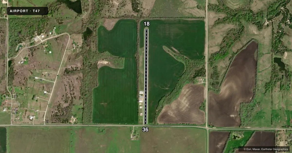
Runways & pattern
Full pagePattern entry · RWY 18
LEFT TRAFFICRunway end performance
| End | TORA | TODA | ASDA | LDA | VGSI | Approach lights | Obstruction |
|---|---|---|---|---|---|---|---|
| 18 | — | — | — | — | — | — | 35', trees, 212' from thr, 150' R of cntrln, slope 6 |
| 36 | — | — | — | — | — | — | 31', pline, 0' from thr, 100' R of cntrln, slope 0 |
Declared distances in feet. TORA = takeoff run available, TODA = takeoff distance, ASDA = accelerate-stop, LDA = landing distance.
Airport sketch
Runways drawn to scale from FAA survey coordinates, rendered over satellite imagery. Not for navigation.
Approaches & charts
Services on the field
Fuel grades, oxygen, maintenance, ramp storage and lighting — as declared to the FAA by the airport operator.
Fuel & services
- Fuel
- Not available
Ramp & ground
- Transient storage
- Not published
- Wind indicator
- Yes
Fuel & FBOs
Cheapest 100LL and Jet A on the field and nearby. Always confirm with the FBO before taxi.
Airport notes
Surface conditions, obstructions, local procedures, lighting outages and other notes published with each FAA cycle.
Other notes
- MANAGERCESSNA7541T@GMAIL.COM
VFR map & nearby airports
VFR sectional. Tap any ICAO chip to open that airport.
Key facts · T47
Answer card- ICAO
- T47
- Name
- FINNEY FLD
- Location
- HOWE, TEXAS
- Elevation
- 833 ft MSL
- Traffic pattern altitude
- 1,833 ft MSL (1,000 AGL)
- Control tower
- Non-towered (use CTAF)
- Total runways
- 1
- Longest runway
- 18/36 · 2,549 ft
- Published ILS approaches
- 0
- Published frequencies
- 0
- Magnetic variation
- –
- Current flight rules
- VFR
- Current wind
- 180° at 7 kt
- Favored runway now
- RWY 18
Finney Fld sits near Howe, Texas. Field elevation is 833 ft MSL. It has one runway, 18/36, which is 2,549 ft long and turf. There is no control tower. No ILS approaches are published for the field.
Pattern altitude is not published. Use the standard 1,000 ft AGL pattern unless the current Chart Supplement says otherwise. That puts the light-piston pattern at about 1,833 ft MSL based on the field elevation. Verify before you fly. The airport is small and simple. Expect a turf surface and plan your rollout and braking with that in mind.
No on-field FBOs are listed. FBO options vary. Contact the airport operator directly before arrival. You can also call the field on CTAF or UNICOM for current FBO availability. The published remarks list a manager contact email as CESSNA7541T@GMAIL.COM. If you need current airport details, use the current FAA Chart Supplement or contact the airport operator directly. For a first-time arrival, the main items are the turf runway, the lack of published instrument approaches and the fact that no tower is in operation.