METAR & TAF X65
X65 does not publish a METAR.
Showing the nearest reporting station: KGYI (NORTH TEXAS RGNL/PERRIN FLD) · 10.7 NM away. Conditions at X65 may differ.
METAR · KGYI
Observed 08:35Z
KGYI 270835Z AUTO 19007KT 10SM CLR 26/20 A2994 RMK AO2 T02580204 $
- Wind
- 190° @ 7 kt
- Visibility
- 10 SM
- Temp / Dew
- 26°C / 20°C
- Altimeter
- 29.94 inHg
- Clouds
- CLR
- Density alt
- 2,355 ft
- Ceiling
- Unlimited
- Rules
- VFR
Airport info & contacts
Manager on record, flight service, ARTCC, attendance schedule and pattern altitude — published by the FAA and refreshed every 28 days.
Location
- From city
- 1 NM NE
- VFR sectional
- DALLAS-FT WORTH
- ARTCC
- ZFW · FORT WORTH
- NOTAM facility
- FTW (NOTAM-D)
Airport manager
- Name
- STEVE MERRITT
- Phone
- 469-759-9976
- Address
- 637 BELDEN ROAD, DORCHESTER TX 75009
Flight service · Hours
- FSS FTW
- FORT WORTH1-800-WX-BRIEF
- Attendance
- MON-FRI · 0700-1600
Frequencies
Tap any row to copy the frequency to your clipboard.
Runways & pattern
Full pagePattern entry · RWY 17
LEFT TRAFFICRunway end performance
| End | TORA | TODA | ASDA | LDA | VGSI | Approach lights | Obstruction |
|---|---|---|---|---|---|---|---|
| 17 | — | — | — | — | — | — | 22', trees, 0' from thr, 96' R of cntrln, slope 0 |
| 35 | — | — | — | — | — | — | 15', road, 125' from thr, 135' R of cntrln, slope 8 |
Declared distances in feet. TORA = takeoff run available, TODA = takeoff distance, ASDA = accelerate-stop, LDA = landing distance.
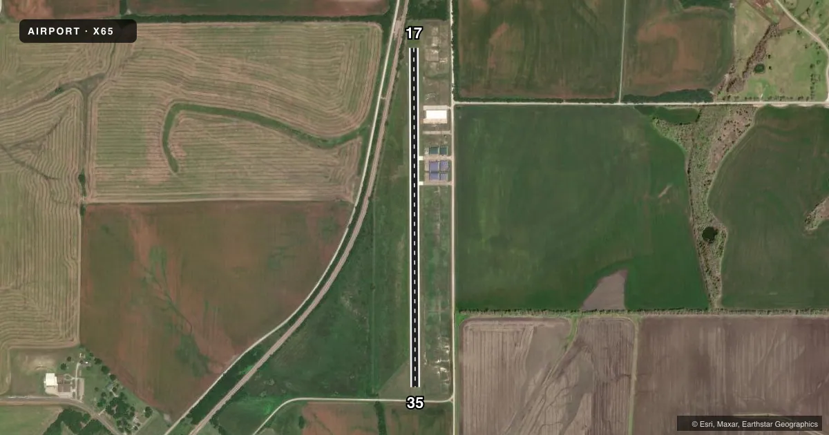
Airport sketch
Runways drawn to scale from FAA survey coordinates, rendered over satellite imagery. Not for navigation.
Approaches & charts
Services on the field
Fuel grades, oxygen, maintenance, ramp storage and lighting — as declared to the FAA by the airport operator.
Fuel & services
- Fuel
- Not available
- Airframe repair
- Major
- Power plant repair
- Major
Ramp & ground
- Transient storage
- Tie-down
- Hangar
- Wind indicator
- Yes
- Segmented circle
- Yes
Fuel & FBOs
Cheapest 100LL and Jet A on the field and nearby. Always confirm with the FBO before taxi.
Airport notes
Surface conditions, obstructions, local procedures, lighting outages and other notes published with each FAA cycle.
General notes
- FOR CD CTC FORT WORTH ARTCC AT 817-858-7584.
- WILDLIFE ON AND INVOF ARPT.
Runway surface & condition
- 17/35MKD WITH ORANGE TFC CONES SET AT 70 FT. WIDE.
Approach & departure obstructions
- 17CONTROLLING OBSTN EXCEEDS A 45 DEG SLP.
Other notes
- PRVDD VFR OPNS, RWY 17 CLEAR 20:1 APCH BY REMOVING TWO OBSTACLES OR ADDING A 350 FT DSPLCD THR; RWY 35 CLEAR 20:1 APCH BY ADDING A 175 FT DSPLCD THR.
VFR map & nearby airports
VFR sectional. Tap any ICAO chip to open that airport.
Key facts · X65
Answer card- ICAO
- X65
- Name
- TXAEROSPORT AERODROME
- Location
- DORCHESTER, TEXAS
- Elevation
- 855 ft MSL
- Traffic pattern altitude
- 1,855 ft MSL (1,000 AGL)
- Control tower
- Non-towered (use CTAF)
- Total runways
- 1
- Longest runway
- 17/35 · 3,200 ft
- Published ILS approaches
- 0
- Published frequencies
- 1
- Magnetic variation
- –
- Current flight rules
- VFR
- Current wind
- 190° at 7 kt
- Favored runway now
- RWY 17
TXAEROSPORT AERODROME sits near Dorchester, Texas. Field elevation is 855 ft MSL. The airport has one runway. Runway 17/35 is 3,200 ft of turf. The field is not towered. CTAF is 122.9.
No ILS approaches are published here. Pattern altitude is not published, so use standard 1,000 ft AGL unless the current Chart Supplement says otherwise. That puts the pattern at 1,855 ft MSL based on the field elevation. Wildlife is present on and near the airport, so keep your scan active on final and in the pattern. The published remarks also call out runway 17/35 markings with orange cones set at 70 ft wide. For VFR operations, runway 17 has a clear 20 to 1 approach only if two obstacles are removed or a 350 ft displaced threshold is used. Runway 35 has a clear 20 to 1 approach only if a 175 ft displaced threshold is added. The controlling obstacle on runway 17 exceeds a 45 degree slope. No on-field FBOs are listed. For clearance delivery, contact Fort Worth ARTCC at 817-858-7584 before departure if you need it.