METAR & TAF T29
T29 does not publish a METAR.
Showing the nearest reporting station: KGLE (GAINESVILLE MUNI) · 12.9 NM away. Conditions at T29 may differ.
METAR · KGLE
Observed 22:55Z
KGLE 262255Z AUTO 14009KT 10SM CLR 36/20 A2996 RMK AO2 T03590202
- Wind
- 140° @ 9 kt
- Visibility
- 10 SM
- Temp / Dew
- 36°C / 20°C
- Altimeter
- 29.96 inHg
- Clouds
- CLR
- Density alt
- 3,413 ft
- Ceiling
- Unlimited
- Rules
- VFR
Airport info & contacts
Manager on record, flight service, ARTCC, attendance schedule and pattern altitude — published by the FAA and refreshed every 28 days.
Location
- From city
- 2 NM SW
- VFR sectional
- DALLAS-FT WORTH
- ARTCC
- ZFW · FORT WORTH
- NOTAM facility
- FTW (NOTAM-D)
Airport manager
- Name
- JEFF HOWLE
- Phone
- 214-802-8008
- Address
- PO BOX 971, WHITESBORO TX 76273
Flight service · Hours
- FSS FTW
- FORT WORTH1-800-WX-BRIEF
- Attendance
- Unattended
Frequencies
Tap any row to copy the frequency to your clipboard.
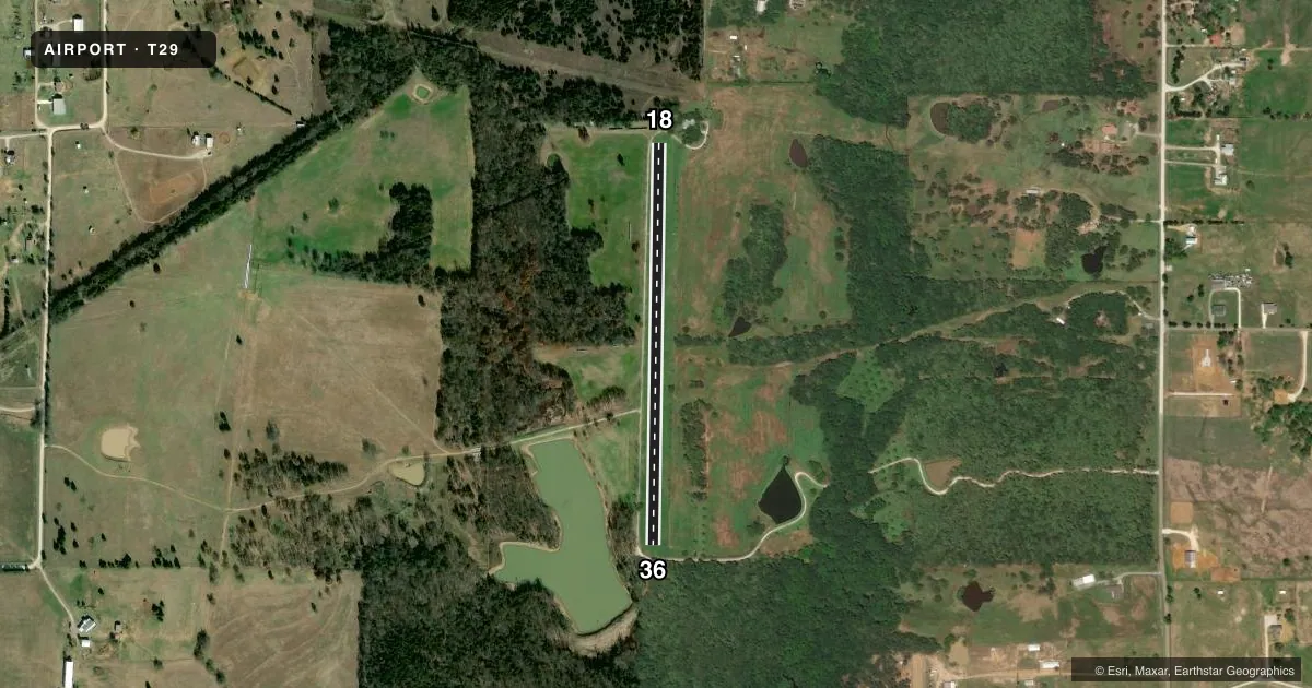
Runways & pattern
Full pagePattern entry · RWY 18
LEFT TRAFFICRunway end performance
| End | TORA | TODA | ASDA | LDA | VGSI | Approach lights | Obstruction |
|---|---|---|---|---|---|---|---|
| 18 | — | — | — | — | — | — | 40', trees, 25' from thr, 125' R of cntrln, slope 0 |
| 36 | — | — | — | — | — | — | 60', trees, 50' from thr, 125' R of cntrln, slope 0 |
Declared distances in feet. TORA = takeoff run available, TODA = takeoff distance, ASDA = accelerate-stop, LDA = landing distance.
Airport sketch
Runways drawn to scale from FAA survey coordinates, rendered over satellite imagery. Not for navigation.
Approaches & charts
Services on the field
Fuel grades, oxygen, maintenance, ramp storage and lighting — as declared to the FAA by the airport operator.
Fuel & services
- Fuel
- Not available
Ramp & ground
- Transient storage
- Not published
- Landing fee
- Yes
- Wind indicator
- Yes
Fuel & FBOs
Cheapest 100LL and Jet A on the field and nearby. Always confirm with the FBO before taxi.
Airport notes
Surface conditions, obstructions, local procedures, lighting outages and other notes published with each FAA cycle.
General notes
- DEER & HOGS ON AND INVOF ARPT.
- NO STUDENT TRNG.
- NO TOUCH AND GO OPNS.
- 75 FT MKD PWR LINES 900 FT FM RWY 18 ACRS CNTRLN.
- FOR FLD COND CALL AMGR 214-802-8008.
- RWY 18/36 45 FT TREE APRX MIDPT OF RWY, 100 FT E OF CNTRLN.
- ARPT PHYS ADS 2227 WEST LINE RD. WHITESBORO TX.
- FOR CD CTC FORT WORTH ARTCC AT 817-858-7584.
- RWY 18/36 CLSD EXC 15 MIN PPR 214-802-8008.
Approach & departure obstructions
- 18DSPLCD THR MKD WITH WHITE CONC TILES EACH SIDE OF RWY.
- 18APCH RATIO 15:1 T0 DSPLCD THR BASED ON STRAIGHT OUT. 2:1 BASED ON 15 FT TREE, 32 FT DSTC, 94 FT. L.
Other notes
- PRVDD CLEAR 20:1 APCHS AND CLEARLY ID OBSTS AND THE DSPLCD THR.
VFR map & nearby airports
VFR sectional. Tap any ICAO chip to open that airport.
Key facts · T29
Answer card- ICAO
- T29
- Name
- FLYING H RANCH
- Location
- WHITESBORO, TEXAS
- Elevation
- 760 ft MSL
- Traffic pattern altitude
- 1,760 ft MSL (1,000 AGL)
- Control tower
- Non-towered (use CTAF)
- Total runways
- 1
- Longest runway
- 18/36 · 2,395 ft
- Published ILS approaches
- 0
- Published frequencies
- 1
- Magnetic variation
- –
- Current flight rules
- VFR
- Current wind
- 140° at 9 kt
- Favored runway now
- RWY 18
Flying H Ranch Airport is in Whitesboro, Texas. The field elevation is 760 ft MSL. It has one runway, 18/36, which is 2,395 ft of turf. There is no control tower. CTAF is 122.9. No ILS approaches are published here.
Pattern altitude is not published. Use the standard 1,000 ft AGL for light piston operations unless the current FAA Chart Supplement says otherwise. This is a field where you want to read the remarks before you go. Runway 18/36 is closed except with 15 minute prior permission required at 214-802-8008. There are marked power lines about 900 ft from runway 18 across the centerline. A 45 ft tree sits near midfield, 100 ft east of centerline. The remarks also call out deer and hogs on and near the airport.
There are no on-field FBOs listed. For field condition calls, contact the airport manager at 214-802-8008. For clearance delivery, Fort Worth ARTCC is listed at 817-858-7584. The airport also notes no student training and no touch-and-go operations. Expect a small, uncontrolled turf strip with obstacle awareness and permission requirements that matter before arrival.