METAR & TAF X16
X16 does not publish a METAR.
Showing the nearest reporting station: KGLE (GAINESVILLE MUNI) · 11.4 NM away. Conditions at X16 may differ.
METAR · KGLE
Observed 20:15Z
KGLE 262015Z AUTO 20011KT 10SM CLR 36/20 A2999 RMK AO2 T03620204
- Wind
- 200° @ 11 kt
- Visibility
- 10 SM
- Temp / Dew
- 36°C / 20°C
- Altimeter
- 29.99 inHg
- Clouds
- CLR
- Density alt
- 3,275 ft
- Ceiling
- Unlimited
- Rules
- VFR
Airport info & contacts
Manager on record, flight service, ARTCC, attendance schedule and pattern altitude — published by the FAA and refreshed every 28 days.
Location
- From city
- 3 NM E
- VFR sectional
- DALLAS-FT WORTH
- ARTCC
- ZFW · FORT WORTH
- NOTAM facility
- FTW (NOTAM-D)
Airport manager
- Name
- MICHAEL CAYLOR
- Phone
- 817-217-3489
- Address
- 70 CUB LN, VALLEY VIEW TX 76272
Flight service · Hours
- FSS FTW
- FORT WORTH1-800-WX-BRIEF
- Attendance
- DAWN-DUSK
Frequencies
Tap any row to copy the frequency to your clipboard.
Runways & pattern
Full pagePattern entry · RWY 18
LEFT TRAFFICRunway end performance
| End | TORA | TODA | ASDA | LDA | VGSI | Approach lights | Obstruction |
|---|---|---|---|---|---|---|---|
| 18 | — | — | — | — | — | — | 16', road, 8' from thr, 135' R of cntrln, slope 0 |
| 36 | — | — | — | — | — | — | 5', fence, 0' from thr, 135' R of cntrln, slope 0 |
Declared distances in feet. TORA = takeoff run available, TODA = takeoff distance, ASDA = accelerate-stop, LDA = landing distance.
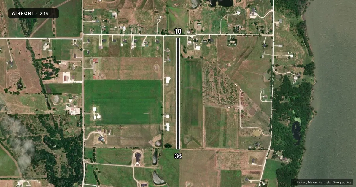
Airport sketch
Runways drawn to scale from FAA survey coordinates, rendered over satellite imagery. Not for navigation.
Approaches & charts
Services on the field
Fuel grades, oxygen, maintenance, ramp storage and lighting — as declared to the FAA by the airport operator.
Fuel & services
- Fuel
- Not available
Ramp & ground
- Transient storage
- Not published
- Wind indicator
- Yes
Fuel & FBOs
Cheapest 100LL and Jet A on the field and nearby. Always confirm with the FBO before taxi.
Airport notes
Surface conditions, obstructions, local procedures, lighting outages and other notes published with each FAA cycle.
General notes
- FOR CD CTC FORT WORTH ARTCC AT 817-858-7584.
- RWY MKD WITH 3 FT DIAM WHITE CONES ALG BOTH SIDES.
Approach & departure obstructions
- 185 FT FARM FENCE ACRS APCH, ALSO 20 FT TREES 44 FT DSTC.
Other notes
- MANAGERAXISMACHINE@YAHOO.COM
VFR map & nearby airports
VFR sectional. Tap any ICAO chip to open that airport.
Key facts · X16
Answer card- ICAO
- X16
- Name
- TAILWHEEL ACRES
- Location
- VALLEY VIEW, TEXAS
- Elevation
- 679 ft MSL
- Traffic pattern altitude
- 1,679 ft MSL (1,000 AGL)
- Control tower
- Non-towered (use CTAF)
- Total runways
- 1
- Longest runway
- 18/36 · 2,450 ft
- Published ILS approaches
- 0
- Published frequencies
- 1
- Magnetic variation
- –
- Current flight rules
- VFR
- Current wind
- 200° at 11 kt
- Favored runway now
- RWY 18
Tailwheel Acres sits in Valley View, Texas. Field elevation is 679 ft MSL. The airport has one runway. Runway 18/36 is 2,450 ft of turf, so plan for soft-field performance and keep your rollout and braking expectations conservative. No control tower is published. CTAF is 122.9. No ILS approaches are published here.
The pattern altitude is not published, so use the standard 1,000 ft AGL unless the current Chart Supplement says otherwise. That puts the traffic pattern at about 1,679 ft MSL based on the field elevation. Verify the published pattern before you go. The runway is marked with 3 ft white cones along both sides. Published remarks also note a 5 ft farm fence across the approach to runway 18. There are 20 ft trees 44 ft from that end as well. That makes the 18 end the one to study closely on arrival and departure.
There are no on-field FBOs listed. Contact the airport operator directly before arrival if you need local support. For clearance delivery, Fort Worth ARTCC is listed in the remarks. If you are planning a first visit, brief the turf surface, the approach obstructions and the lack of published instrument approaches before you launch.