METAR & TAF 7T0
7T0 does not publish a METAR.
Showing the nearest reporting station: KGLE (GAINESVILLE MUNI) · 3.7 NM away. Conditions at 7T0 may differ.
METAR · KGLE
Observed 06:35Z
KGLE 240635Z AUTO 08005KT 10SM CLR 21/21 A3007 RMK AO2 T02140210
- Wind
- 080° @ 5 kt
- Visibility
- 10 SM
- Temp / Dew
- 21°C / 21°C
- Altimeter
- 30.07 inHg
- Clouds
- CLR
- Density alt
- 1,631 ft
- Ceiling
- Unlimited
- Rules
- VFR
Airport info & contacts
Manager on record, flight service, ARTCC, attendance schedule and pattern altitude — published by the FAA and refreshed every 28 days.
Location
- From city
- 3 NM S
- VFR sectional
- DALLAS-FT WORTH
- ARTCC
- ZFW · FORT WORTH
- NOTAM facility
- FTW (NOTAM-D)
Airport manager
- Name
- TOM SCHAD
- Phone
- 940-736-6464
- Address
- 2961 FM 1630, GAINESVILLE TX 76240
Flight service · Hours
- FSS FTW
- FORT WORTH1-800-WX-BRIEF
- Attendance
- Unattended
Frequencies
Tap any row to copy the frequency to your clipboard.
Runways & pattern
Full pagePattern entry · RWY 35
LEFT TRAFFICRunway end performance
| End | TORA | TODA | ASDA | LDA | VGSI | Approach lights | Obstruction |
|---|---|---|---|---|---|---|---|
| 17 | — | — | — | — | — | — | 15', road, 25' from thr, 125' R of cntrln, slope 1 |
| 35 | — | — | — | — | — | — | 15', road, 50' from thr, 125' R of cntrln, slope 3 |
Declared distances in feet. TORA = takeoff run available, TODA = takeoff distance, ASDA = accelerate-stop, LDA = landing distance.
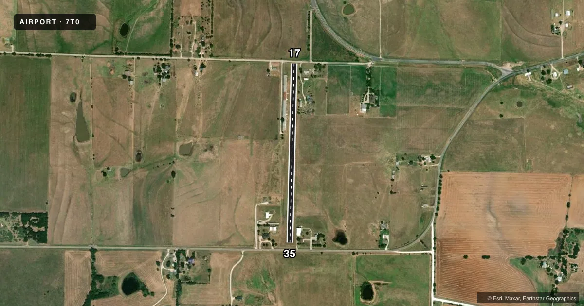
Airport sketch
Runways drawn to scale from FAA survey coordinates, rendered over satellite imagery. Not for navigation.
Approaches & charts
Services on the field
Fuel grades, oxygen, maintenance, ramp storage and lighting — as declared to the FAA by the airport operator.
Fuel & services
- Fuel
- Not available
Ramp & ground
- Transient storage
- Not published
- Landing fee
- No fee published
- Wind indicator
- Yes
- Segmented circle
- No
Fuel & FBOs
Cheapest 100LL and Jet A on the field and nearby. Always confirm with the FBO before taxi.
Airport notes
Surface conditions, obstructions, local procedures, lighting outages and other notes published with each FAA cycle.
General notes
- OCNL LIVESTOCK ON RWY.
- RWY 17, 40 FT POLE, 55 FT DSTC, 90 FT L, 200 FT R. LINES BURIED UNDER APCH.
- NO STUDENT TFC, NO HELS.
- RWY SOFT AFT RAIN. CALL TO CFM COND.
- FOR CD CTC FORT WORTH ARTCC AT 817-858-7584.
- RWY 35, 34 FT POLE, 20 FT DSTC, 230 FT L, 130 R. LINES BURIED UNDER APCH.
Other notes
- PRVDD ONLY VFR APCHS PERMITTED; A CLEAR 20:1 APCH SLOPE TO BOTH RY ENDS AT ALL TIMES; AND MONITOR GAINESVILLE CTAF OF 123.0.
VFR map & nearby airports
VFR sectional. Tap any ICAO chip to open that airport.
Key facts · 7T0
Answer card- ICAO
- 7T0
- Name
- FREEDOM FLD
- Location
- LINDSAY, TEXAS
- Elevation
- 885 ft MSL
- Traffic pattern altitude
- 1,885 ft MSL (1,000 AGL)
- Control tower
- Non-towered (use CTAF)
- Total runways
- 1
- Longest runway
- 17/35 · 2,400 ft
- Published ILS approaches
- 0
- Published frequencies
- 1
- Magnetic variation
- 7°
- Current flight rules
- VFR
- Current wind
- 080° at 5 kt
- Favored runway now
- RWY 35
Freedom Fld sits in Lindsay, Texas. The field elevation is 885 ft MSL. It has one runway. Runway 17/35 is 2,400 ft of turf, so plan for soft-field handling and a longer roll than you would expect on pavement. There is no control tower. CTAF is 122.9.
No ILS approaches are published here. The pattern altitude is not published, so use the standard 1,000 ft AGL for light piston operations unless the current Chart Supplement says otherwise. The runway is marked as visual only. Published remarks say there must be a clear 20 to 1 approach slope to both runway ends at all times. They also note occasional livestock on the runway. The runway can be soft after rain, so call to confirm condition before departure.
There are no on-field FBOs listed. If you need current fuel or service availability, contact the airport operator or call the field directly. Published remarks also note a 34-foot pole near the Runway 35 end and a 40-foot pole near the Runway 17 end. Both are close enough to matter on short final. For clearance delivery, Fort Worth ARTCC is listed in the remarks. This is a small turf strip with no student traffic and no helicopters. Keep your scan tight and verify the runway is clear before you commit.