METAR & TAF 0F2
Current METAR
Observed 07:15Z
K0F2 270715Z AUTO 15003KT 10SM CLR 26/18 A2996 RMK AO2 T02600180
- Wind
- 150° @ 3 kt
- Visibility
- 10 SM
- Temp / Dew
- 26°C / 18°C
- Altimeter
- 29.96 inHg
- Clouds
- CLR
- Density alt
- 2,635 ft
- Ceiling
- Unlimited
- Rules
- VFR
Airport info & contacts
Manager on record, flight service, ARTCC, attendance schedule and pattern altitude — published by the FAA and refreshed every 28 days.
Location
- From city
- 4 NM NE
- VFR sectional
- DALLAS-FT WORTH
- ARTCC
- ZFW · FORT WORTH
- NOTAM facility
- FTW (NOTAM-D)
Airport manager
- Name
- STONY LOWRANCE
- Phone
- 940-841-4156
- Address
- 303 N MASON, BOWIE TX 76230
Flight service · Hours
- FSS FTW
- FORT WORTH1-800-WX-BRIEF
- Attendance
- MON-FRI · 0730-1630
Frequencies
Tap any row to copy the frequency to your clipboard.
Runways & pattern
Full pagePattern entry · RWY 17
LEFT TRAFFICRunway end performance
| End | TORA | TODA | ASDA | LDA | VGSI | Approach lights | Obstruction |
|---|---|---|---|---|---|---|---|
| 17 | — | — | — | — | PAPI 2-box left(3°) | — | 26', pole, 620' from thr, 208' R of cntrln, slope 16 |
| 35 | — | — | — | — | PAPI 2-box left(3°) | — | 5', trees, 200' from thr, 210' R of cntrln, slope 0 |
Declared distances in feet. TORA = takeoff run available, TODA = takeoff distance, ASDA = accelerate-stop, LDA = landing distance.
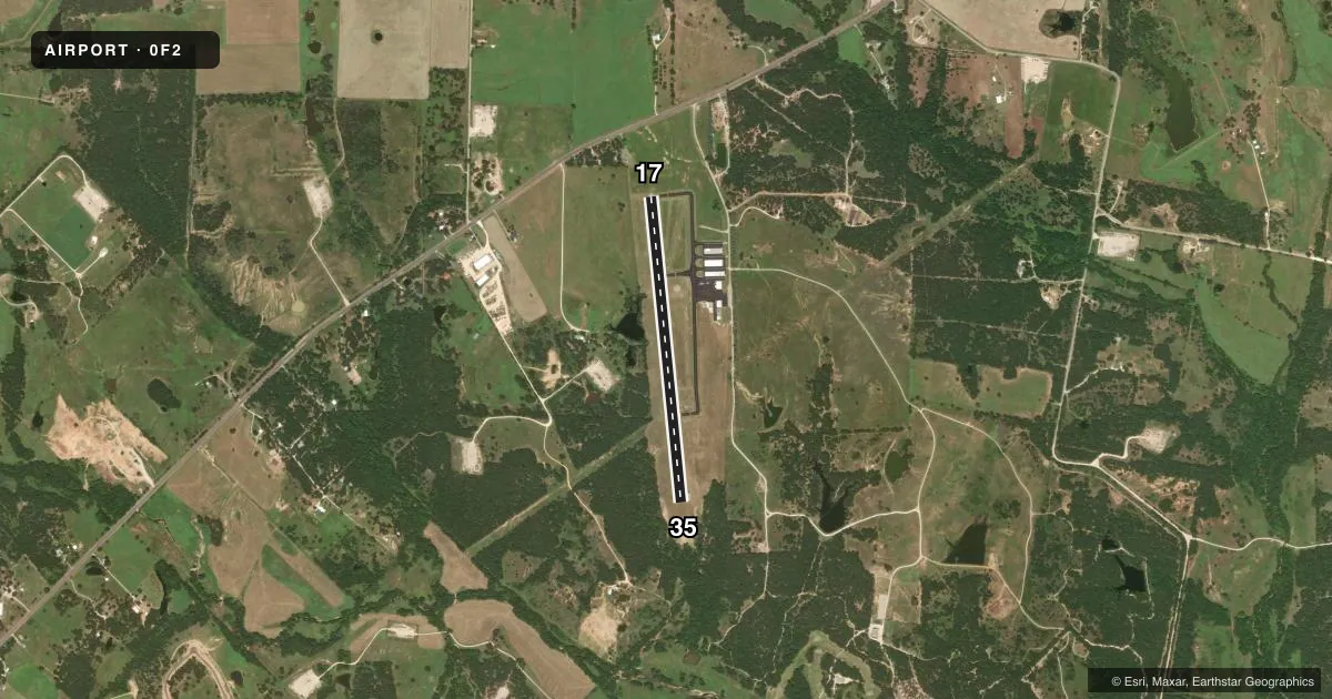
Airport sketch
Runways drawn to scale from FAA survey coordinates, rendered over satellite imagery. Not for navigation.
Approaches & charts
Services on the field
Fuel grades, oxygen, maintenance, ramp storage and lighting — as declared to the FAA by the airport operator.
Fuel & services
- Fuel
- 100LLA
- Oxygen (bottled)
- Not available
- Oxygen (bulk)
- Not available
- Other services
- AGRI
Ramp & ground
- Transient storage
- Tie-down
- Hangar
- Landing fee
- No fee published
- Customs
- Not available
- Lighting schedule
- SEE RMK
- Beacon schedule
- SS-SR
- Beacon
- White / Green (civil land)(WG)
- Wind indicator
- Lighted
- Segmented circle
- Yes
Fuel & FBOs
Cheapest 100LL and Jet A on the field and nearby. Always confirm with the FBO before taxi.
Airport notes
Surface conditions, obstructions, local procedures, lighting outages and other notes published with each FAA cycle.
General notes
- RWY 17/35 PVMT LIP 1.5 INCHES ABV GRADE.
- DEER ON & INVOF ARPT.
- RWY 35 30 FT DROP-OFF 190 FT DSTC, BOTH SIDES.
- CROP DUSTING JAN-APRIL.
- FOR CD CTC FORT WORTH ARTCC AT 817-858-7584.
Lighting notes
- DUSK-DAWN. ACTVT PAPI RWY 17 & 35; MIRL RWY 17/35 - CTAF.
Fuel notes
- 100LL100LL & JET A 24 HR SELF-SERVE.
Approach & departure obstructions
- 174 FT FENCE, 0-199 FT DSTC, 246 FT. RIGHT.
- 358 FT TREES 0-200 FM THR 228 FT L.
Other notes
- 1FOR ARPT ATTENDANT AFT HRS CALL 940-841-4156.
- MANAGERPUBLIC WORKS DIR./AMGR.
- AGRIEXTENSIVE AGRI OPS JAN-APR.
VFR map & nearby airports
VFR sectional. Tap any ICAO chip to open that airport.
Key facts · 0F2
Answer card- ICAO
- 0F2
- Name
- BOWIE MUNI
- Location
- BOWIE, TEXAS
- Elevation
- 1,100.5 ft MSL
- Traffic pattern altitude
- 2,100.5 ft MSL (1,000 AGL)
- Control tower
- Non-towered (use CTAF)
- Total runways
- 1
- Longest runway
- 17/35 · 3,603 ft
- Published ILS approaches
- 0
- Published frequencies
- 2
- Magnetic variation
- 4°
- Current flight rules
- VFR
- Current wind
- 150° at 3 kt
- Favored runway now
- RWY 17
Bowie Muni sits in Bowie, Texas. The field elevation is 1,100.5 ft MSL. It has one runway. Runway 17/35 is 3,603 ft long with asphalt pavement. There is no control tower. No ILS approaches are published here.
Pattern altitude is not published. Use the standard 1,000 ft AGL pattern for light piston traffic unless the current FAA Chart Supplement says otherwise. The airport uses CTAF 122.8. UNICOM is also 122.8. From dusk to dawn, the PAPI on runways 17 and 35 activates by CTAF. The medium intensity runway lights on runway 17/35 also activate by CTAF.
Bowie Municipal Airport is the on-field FBO. It carries 100LL and Jet A. Fuel is available 24 hours by self-service. For after-hours airport attendant help, call 940-841-4156. First-time pilots should pay attention to the runway edges and nearby obstructions. Runway 35 has trees near the threshold on the left side. Runway 17 has a fence close in on the right side. Runway 35 also has a drop-off area on both sides. Crop dusting and other agricultural work occur from January through April. Deer are also reported on and near the airport. For clearance delivery, contact Fort Worth ARTCC at 817-858-7584.