METAR & TAF E58
E58 does not publish a METAR.
Showing the nearest reporting station: KDTO (DENTON ENTERPRISE) · 9.7 NM away. Conditions at E58 may differ.
METAR · KDTO
Observed 09:53Z
KDTO 270953Z AUTO 00000KT 10SM CLR 23/20 A2993 RMK AO2 SLP124 T02330200
- Wind
- 000° @ 0 kt
- Visibility
- 10 SM
- Temp / Dew
- 23°C / 20°C
- Altimeter
- 29.93 inHg
- Clouds
- CLR
- Density alt
- 2,057 ft
- Ceiling
- Unlimited
- Rules
- VFR
Airport info & contacts
Manager on record, flight service, ARTCC, attendance schedule and pattern altitude — published by the FAA and refreshed every 28 days.
Location
- From city
- 8 NM E
- VFR sectional
- DALLAS-FT WORTH
- ARTCC
- ZFW · FORT WORTH
- NOTAM facility
- FTW (NOTAM-D)
Airport manager
- Name
- SCOTT SACKETT
- Phone
- 940-367-1992
- Address
- 9300 S. HICKORY ROAD, KRUM TX 76249
Flight service · Hours
- FSS FTW
- FORT WORTH1-800-WX-BRIEF
- Attendance
- Unattended
Frequencies
Tap any row to copy the frequency to your clipboard.
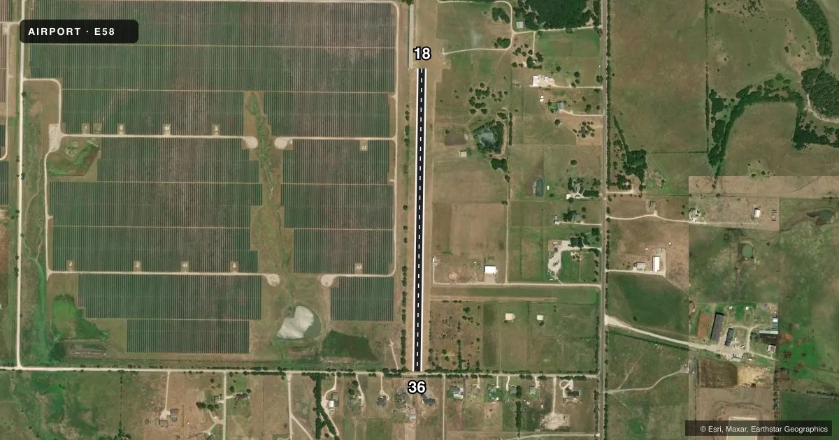
Runways & pattern
Full pagePattern entry · RWY 18
LEFT TRAFFICRunway end performance
| End | TORA | TODA | ASDA | LDA | VGSI | Approach lights | Obstruction |
|---|---|---|---|---|---|---|---|
| 18 | — | — | — | — | — | — | 16', bldg, 0' from thr, 85' R of cntrln, slope 0 |
| 36 | — | — | — | — | — | — | 27', tree, 0' from thr, 75' R of cntrln, slope 0 |
Declared distances in feet. TORA = takeoff run available, TODA = takeoff distance, ASDA = accelerate-stop, LDA = landing distance.
Airport sketch
Runways drawn to scale from FAA survey coordinates, rendered over satellite imagery. Not for navigation.
Approaches & charts
Services on the field
Fuel grades, oxygen, maintenance, ramp storage and lighting — as declared to the FAA by the airport operator.
Fuel & services
- Fuel
- Not available
Ramp & ground
- Transient storage
- Not published
- Landing fee
- Yes
- Wind indicator
- Yes
- Segmented circle
- No
Fuel & FBOs
Cheapest 100LL and Jet A on the field and nearby. Always confirm with the FBO before taxi.
Airport notes
Surface conditions, obstructions, local procedures, lighting outages and other notes published with each FAA cycle.
General notes
- RWY MEASURED 200 FT WIDE.
- FOR CD CTC LONE STAR APCH AT 972-615-2799.
- RWY 18/36 DSPLCD THRS NOT MKD.
- ARPT PHYS ADDR 12598 AIR BOB LN. KRUM, TX.
Approach & departure obstructions
- 18ALSO 25 FT TREE, 90 FT R, 0:1; 15 FT RD, 23 FT. DSTC. 1:1.
Other notes
- PRVDD VFR OPERATIONS AND CLEAR 20:1 APCHS.
- 100 DOLLAR LDG FEE ALL ACFT.
VFR map & nearby airports
VFR sectional. Tap any ICAO chip to open that airport.
Key facts · E58
Answer card- ICAO
- E58
- Name
- BIRD DOG AIRFIELD
- Location
- KRUM, TEXAS
- Elevation
- 895 ft MSL
- Traffic pattern altitude
- 1,895 ft MSL (1,000 AGL)
- Control tower
- Non-towered (use CTAF)
- Total runways
- 1
- Longest runway
- 18/36 · 2,830 ft
- Published ILS approaches
- 0
- Published frequencies
- 1
- Magnetic variation
- 6°
- Current flight rules
- VFR
- Current wind
- 000° at 0 kt
- Favored runway now
- –
Bird Dog Airfield sits near Krum, Texas. Field elevation is 895 ft MSL. The airport has one runway, 18/36, which is 2,830 ft long and turf. It is a non-towered field. CTAF is 122.9. No ILS approaches are published here.
The pattern altitude is not published. Use the standard 1,000 ft AGL pattern unless the current Chart Supplement says otherwise. That puts the traffic pattern at 1,895 ft MSL based on the field elevation. The runway is measured 200 feet wide. The published remarks say the field supports VFR operations with clear 20 to 1 approaches. They also note that the displaced thresholds on 18/36 are not marked.
There are no on-field FBOs listed. Plan on confirming services with the airport operator before arrival. The published remarks also list a $100 landing fee for all aircraft. For clearance delivery, contact Lone Star Approach at 972-615-2799. The airport address is 12598 Air Bob Lane, Krum, Texas. The runway 18 end has nearby obstacles listed in the remarks, including a tree and a road. Give that end a close look on your preflight and arrival planning.