METAR & TAF T28
T28 does not publish a METAR.
Showing the nearest reporting station: KLUD (DECATUR MUNI) · 9.3 NM away. Conditions at T28 may differ.
METAR · KLUD
Observed 07:15Z
KLUD 250715Z AUTO 17010G15KT 10SM CLR 28/22 A3003 RMK AO2
- Wind
- 170° @ 10G15 kt
- Visibility
- 10 SM
- Temp / Dew
- 28°C / 22°C
- Altimeter
- 30.03 inHg
- Clouds
- CLR
- Density alt
- 2,561 ft
- Ceiling
- Unlimited
- Rules
- VFR
Airport info & contacts
Manager on record, flight service, ARTCC, attendance schedule and pattern altitude — published by the FAA and refreshed every 28 days.
Location
- From city
- 4 NM W
- VFR sectional
- DALLAS-FT WORTH
- ARTCC
- ZFW · FORT WORTH
- NOTAM facility
- FTW (NOTAM-D)
Airport manager
- Name
- RON CAIN
- Phone
- 972-241-7076
- Address
- PO BOX 123, SLIDELL TX 76267
Flight service · Hours
- FSS FTW
- FORT WORTH1-800-WX-BRIEF
- Attendance
- ALL
Frequencies
Tap any row to copy the frequency to your clipboard.
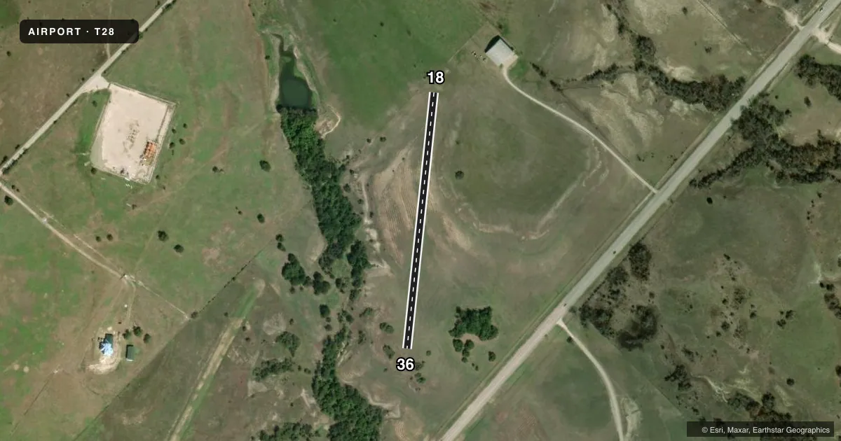
Runways & pattern
Full pagePattern entry · RWY 18
LEFT TRAFFICRunway end performance
| End | TORA | TODA | ASDA | LDA | VGSI | Approach lights | Obstruction |
|---|---|---|---|---|---|---|---|
| 18 | — | — | — | — | — | — | 4', fence, 0' from thr, 30' R of cntrln, slope 0 |
| 36 | — | — | — | — | — | — | 16', brush, 0' from thr, 30' R of cntrln, slope 0 |
Declared distances in feet. TORA = takeoff run available, TODA = takeoff distance, ASDA = accelerate-stop, LDA = landing distance.
Airport sketch
Runways drawn to scale from FAA survey coordinates, rendered over satellite imagery. Not for navigation.
Approaches & charts
Services on the field
Fuel grades, oxygen, maintenance, ramp storage and lighting — as declared to the FAA by the airport operator.
Fuel & services
- Fuel
- Not available
Ramp & ground
- Transient storage
- Not published
- Wind indicator
- Yes
Fuel & FBOs
Cheapest 100LL and Jet A on the field and nearby. Always confirm with the FBO before taxi.
Airport notes
Surface conditions, obstructions, local procedures, lighting outages and other notes published with each FAA cycle.
General notes
- RECOMMEND STOL ACFT OPNS ONLY.
- DEER & FERAL HOGS ON AND INVOF ARPT.
- FOR CD CTC LONE STAR APCH AT 972-615-2799.
Runway surface & condition
- 18/368-10 FT RISING TERRAIN EAST OF RWY. ROLLING TERRAIN, RWY ENDS NOT VISIBLE FROM OPPOSITE END.
Other notes
- PRVDD LETTER OF AGREEMENT WITH BISHOP ARPT (76T) AND DECATUR MUNI (LUD) TO PRVD COMPATIBLE TRAFFIC PAT OPNS.
- MANAGERRONSUPERCUB@HOTMAIL.COM
- 18/36RWY ROUGH, SOME PORTIONS GRAVEL; CALL PRIOR TO USE FOR RWY COND.
VFR map & nearby airports
VFR sectional. Tap any ICAO chip to open that airport.
Key facts · T28
Answer card- ICAO
- T28
- Name
- CAIN
- Location
- SLIDELL, TEXAS
- Elevation
- 917 ft MSL
- Traffic pattern altitude
- 1,917 ft MSL (1,000 AGL)
- Control tower
- Non-towered (use CTAF)
- Total runways
- 1
- Longest runway
- 18/36 · 1,200 ft
- Published ILS approaches
- 0
- Published frequencies
- 1
- Magnetic variation
- –
- Current flight rules
- VFR
- Current wind
- 170° at 10 kt
- Favored runway now
- RWY 18
CAIN (T28) sits in Slidell, Texas at 917 ft MSL. It has one runway. Runway 18/36 is 1,200 ft long and turf. The field is not towered. CTAF is 122.9. No ILS approaches are published here.
Pattern altitude is not published. Use the standard 1,000 ft AGL pattern unless the current FAA Chart Supplement or airport manager says otherwise. The runway is rough in spots and some sections have gravel. Call ahead before you go. The published remarks also say only short takeoff and landing aircraft operations are recommended. That is a good clue on what this strip is built for.
Terrain matters here. There is rising ground east of the runway. The terrain is rolling. The runway ends are not visible from the opposite end. Deer and feral hogs are reported on and near the airport, so keep a sharp scan on taxi and on final. A letter of agreement is in place with Bishop Airport (76T) and Decatur Municipal (LUD) for compatible traffic pattern operations. For clearance delivery, contact Lone Star Approach at 972-615-2799. There are no on-field FBOs listed, so verify services with the airport manager before arrival.