METAR & TAF 76T
76T does not publish a METAR.
Showing the nearest reporting station: KLUD (DECATUR MUNI) · 6.5 NM away. Conditions at 76T may differ.
METAR · KLUD
Observed 21:15Z
KLUD 252115Z AUTO 19007G14KT 10SM CLR 37/18 A3001 RMK AO2
- Wind
- 190° @ 7G14 kt
- Visibility
- 10 SM
- Temp / Dew
- 37°C / 18°C
- Altimeter
- 30.01 inHg
- Clouds
- CLR
- Density alt
- 3,630 ft
- Ceiling
- Unlimited
- Rules
- VFR
Airport info & contacts
Manager on record, flight service, ARTCC, attendance schedule and pattern altitude — published by the FAA and refreshed every 28 days.
Location
- From city
- 6 NM E
- VFR sectional
- DALLAS-FT WORTH
- ARTCC
- ZFW · FORT WORTH
- NOTAM facility
- FTW (NOTAM-D)
Airport manager
- Name
- TOM BISHOP
- Phone
- 940-389-6100
- Address
- 330 PR 2506, DECATUR TX 76234
Flight service · Hours
- FSS FTW
- FORT WORTH1-800-WX-BRIEF
- Attendance
- Unattended
Frequencies
Tap any row to copy the frequency to your clipboard.
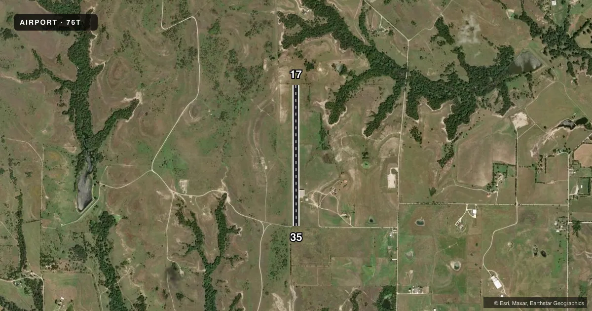
Runways & pattern
Full pagePattern entry · RWY 17
LEFT TRAFFICRunway end performance
| End | TORA | TODA | ASDA | LDA | VGSI | Approach lights | Obstruction |
|---|---|---|---|---|---|---|---|
| 17 | — | — | — | — | — | — | 8', pole, 0' from thr, 0' R of cntrln, slope 0 |
| 35 | — | — | — | — | — | — | 4', fence, 0' from thr, 125' R of cntrln, slope 0 |
Declared distances in feet. TORA = takeoff run available, TODA = takeoff distance, ASDA = accelerate-stop, LDA = landing distance.
Airport sketch
Runways drawn to scale from FAA survey coordinates, rendered over satellite imagery. Not for navigation.
Approaches & charts
Services on the field
Fuel grades, oxygen, maintenance, ramp storage and lighting — as declared to the FAA by the airport operator.
Fuel & services
- Fuel
- Not available
- Airframe repair
- Major
- Power plant repair
- Major
- Other services
- GLD,INSTR,SALES
Ramp & ground
- Transient storage
- Tie-down
- Hangar
- Wind indicator
- Yes
- Segmented circle
- No
Fuel & FBOs
Cheapest 100LL and Jet A on the field and nearby. Always confirm with the FBO before taxi.
Airport notes
Surface conditions, obstructions, local procedures, lighting outages and other notes published with each FAA cycle.
General notes
- RWY MAY BE ROUGH DUE TO DROUGHT CONDS.
- RWY SOFT AFT HVY RAIN.
- FOR RWY CONDS CALL 940-389-6100, OR 940-389-6200.
- FOR CD CTC LONE STAR APCH AT 972-615-2799.
- FOUR 20 FT WHITE POLES 45 FT FROM W. RUNWAY EDGE.
Approach & departure obstructions
- 178 FT TREE, 0 FT DSTC, 75 FT R; ALSO 21 FT TREE, 260 FT DSTC, 100 FT R.
VFR map & nearby airports
VFR sectional. Tap any ICAO chip to open that airport.
Key facts · 76T
Answer card- ICAO
- 76T
- Name
- BISHOP
- Location
- DECATUR, TEXAS
- Elevation
- 888 ft MSL
- Traffic pattern altitude
- 1,888 ft MSL (1,000 AGL)
- Control tower
- Non-towered (use CTAF)
- Total runways
- 1
- Longest runway
- 17/35 · 3,730 ft
- Published ILS approaches
- 0
- Published frequencies
- 1
- Magnetic variation
- 7°
- Current flight rules
- VFR
- Current wind
- 190° at 7 kt
- Favored runway now
- RWY 17
Bishop Airport is in Decatur, Texas. The field elevation is 888 ft MSL. It has one runway, 17/35, which is 3,730 ft long and turf. The airport is non-towered. CTAF is 122.9. No ILS approaches are published.
Pattern altitude is not published. Use the standard 1,000 ft AGL pattern for light piston operations unless the current FAA Chart Supplement says otherwise. That puts the pattern at 1,888 ft MSL based on the field elevation. The runway may be rough in drought conditions. It can also be soft after heavy rain. There are four 20-foot white poles 45 feet from the west runway edge. Runway 17 also has tree obstructions near the departure end, so give that end a close look before you go.
There are no on-field FBOs listed. Contact the airport operator directly before arrival if you need local support. For clearance delivery, the published remark points pilots to Lone Star Approach. For runway condition reports, use the listed phone numbers before you launch. This is a turf strip with a short runway by jet standards. Plan for surface condition. Plan for wind. Plan for performance margins before you commit.