METAR & TAF 58T
58T does not publish a METAR.
Showing the nearest reporting station: KLUD (DECATUR MUNI) · 7.3 NM away. Conditions at 58T may differ.
METAR · KLUD
Observed 10:55Z
KLUD 271055Z AUTO 19009KT 10SM CLR 26/19 A2994 RMK AO2
- Wind
- 190° @ 9 kt
- Visibility
- 10 SM
- Temp / Dew
- 26°C / 19°C
- Altimeter
- 29.94 inHg
- Clouds
- CLR
- Density alt
- 2,390 ft
- Ceiling
- Unlimited
- Rules
- VFR
Airport info & contacts
Manager on record, flight service, ARTCC, attendance schedule and pattern altitude — published by the FAA and refreshed every 28 days.
Location
- From city
- 9 NM SE
- VFR sectional
- DALLAS-FT WORTH
- ARTCC
- ZFW · FORT WORTH
- NOTAM facility
- FTW (NOTAM-D)
Airport manager
- Name
- BRYAN FAIR, PRESIDENT
- Phone
- 817-988-9745
- Address
- 186 RED BARON DR, RHOME TX 76078
Flight service · Hours
- FSS FTW
- FORT WORTH1-800-WX-BRIEF
- Attendance
- Unattended
Frequencies
Tap any row to copy the frequency to your clipboard.
Runways & pattern
Full pagePattern entry · RWY 13
LEFT TRAFFICRunway end performance
| End | TORA | TODA | ASDA | LDA | VGSI | Approach lights | Obstruction |
|---|---|---|---|---|---|---|---|
| 13 | — | — | — | — | — | — | 20', tree, 287' from thr, 85' R of cntrln, slope 14 |
| 31 | — | — | — | — | — | — | 30', tree, 740' from thr, 70' R of cntrln, slope 24 |
Declared distances in feet. TORA = takeoff run available, TODA = takeoff distance, ASDA = accelerate-stop, LDA = landing distance.
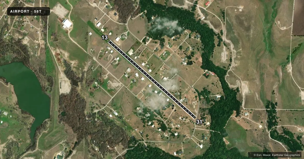
Airport sketch
Runways drawn to scale from FAA survey coordinates, rendered over satellite imagery. Not for navigation.
Approaches & charts
Services on the field
Fuel grades, oxygen, maintenance, ramp storage and lighting — as declared to the FAA by the airport operator.
Fuel & services
- Fuel
- Not available
- Airframe repair
- Major
- Power plant repair
- Major
Ramp & ground
- Transient storage
- Not published
- Lighting schedule
- SEE RMK
- Wind indicator
- Lighted
- Segmented circle
- No
Fuel & FBOs
Cheapest 100LL and Jet A on the field and nearby. Always confirm with the FBO before taxi.
Airport notes
Surface conditions, obstructions, local procedures, lighting outages and other notes published with each FAA cycle.
General notes
- DEER & BIRDS ON AND INVOF ARPT.
- ALL ACFT MONITOR CTAF DUE TO THE CLOSE PROXIMITY TO RHOME MEADOWS ARPT T76.
- RCO CTL MODEL ACFT OPS ON ARPT.
- FOR CD CTC LONE STAR APCH AT 972-615-2799.
- DAYS: RWY DEFINED BY WHITE "L" MARKERS ON EACH CORNER - NIGHTS: TWO LIGHTS EACH SIDE OF CNTRLN MARK RWY ENDS.
Lighting notes
- ACTVT LIRL RWY 13/31 - CTAF.
Approach & departure obstructions
- 31RIGHT TFC FOR FIXED WING ACFT; REMAIN EAST OF THE RWY.
VFR map & nearby airports
VFR sectional. Tap any ICAO chip to open that airport.
Key facts · 58T
Answer card- ICAO
- 58T
- Name
- HERITAGE CREEK AIRSTRIP
- Location
- DECATUR, TEXAS
- Elevation
- 883 ft MSL
- Traffic pattern altitude
- 1,883 ft MSL (1,000 AGL)
- Control tower
- Non-towered (use CTAF)
- Total runways
- 1
- Longest runway
- 13/31 · 3,000 ft
- Published ILS approaches
- 0
- Published frequencies
- 1
- Magnetic variation
- 7°
- Current flight rules
- VFR
- Current wind
- 190° at 9 kt
- Favored runway now
- RWY 13
Heritage Creek Airstrip (58T) sits near Decatur, Texas. Field elevation is 883 ft MSL. The airport has one runway. Runway 13/31 is 3,000 ft of turf, so plan for soft-field technique and check performance carefully before departure. No tower is published here. CTAF is 122.9. No ILS approaches are published. The pattern altitude is not published. Use the standard 1,000 ft AGL pattern unless the current Chart Supplement says otherwise. That puts the traffic pattern at 1,883 ft MSL based on the field elevation.
The published remarks matter here. Right traffic applies for fixed-wing aircraft on Runway 31. Stay east of the runway. Monitor the common traffic advisory frequency because Rhome Meadows Airport T76 is close by. Deer and birds are reported on and near the field. Low intensity runway lights on 13/31 are activated by CTAF. During the day, white L markers show the runway corners. At night, two lights on each side mark the runway ends. For clearance delivery, contact Lone Star Approach at 972-615-2799. No on-field FBOs are listed, so verify fuel and services with the airport operator or the FBO directly before you go.