METAR & TAF 09T
09T does not publish a METAR.
Showing the nearest reporting station: KLUD (DECATUR MUNI) · 4.5 NM away. Conditions at 09T may differ.
METAR · KLUD
Observed 07:35Z
KLUD 250735Z AUTO 17010G15KT 10SM CLR 28/22 A3003 RMK AO2
- Wind
- 170° @ 10G15 kt
- Visibility
- 10 SM
- Temp / Dew
- 28°C / 22°C
- Altimeter
- 30.03 inHg
- Clouds
- CLR
- Density alt
- 2,578 ft
- Ceiling
- Unlimited
- Rules
- VFR
Airport info & contacts
Manager on record, flight service, ARTCC, attendance schedule and pattern altitude — published by the FAA and refreshed every 28 days.
Location
- From city
- 5 NM NE
- VFR sectional
- DALLAS-FT WORTH
- ARTCC
- ZFW · FORT WORTH
- NOTAM facility
- FTW (NOTAM-D)
Airport manager
- Name
- DONALD R. GLITTENBERG
- Phone
- 719-221-7993
- Address
- 175 PR 2321, DECATUR TX 76234
Flight service · Hours
- FSS FTW
- FORT WORTH1-800-WX-BRIEF
- Attendance
- Unattended
Frequencies
Tap any row to copy the frequency to your clipboard.
Runways & pattern
Full pagePattern entry · RWY 17
RIGHT TRAFFICRunway end performance
| End | TORA | TODA | ASDA | LDA | VGSI | Approach lights | Obstruction |
|---|---|---|---|---|---|---|---|
| 17 | — | — | — | — | — | — | 15', tree, 0' from thr, 45' R of cntrln, slope 0 |
| 35 | — | — | — | — | — | — | 15', tree, 0' from thr, 45' R of cntrln, slope 0 |
Declared distances in feet. TORA = takeoff run available, TODA = takeoff distance, ASDA = accelerate-stop, LDA = landing distance.
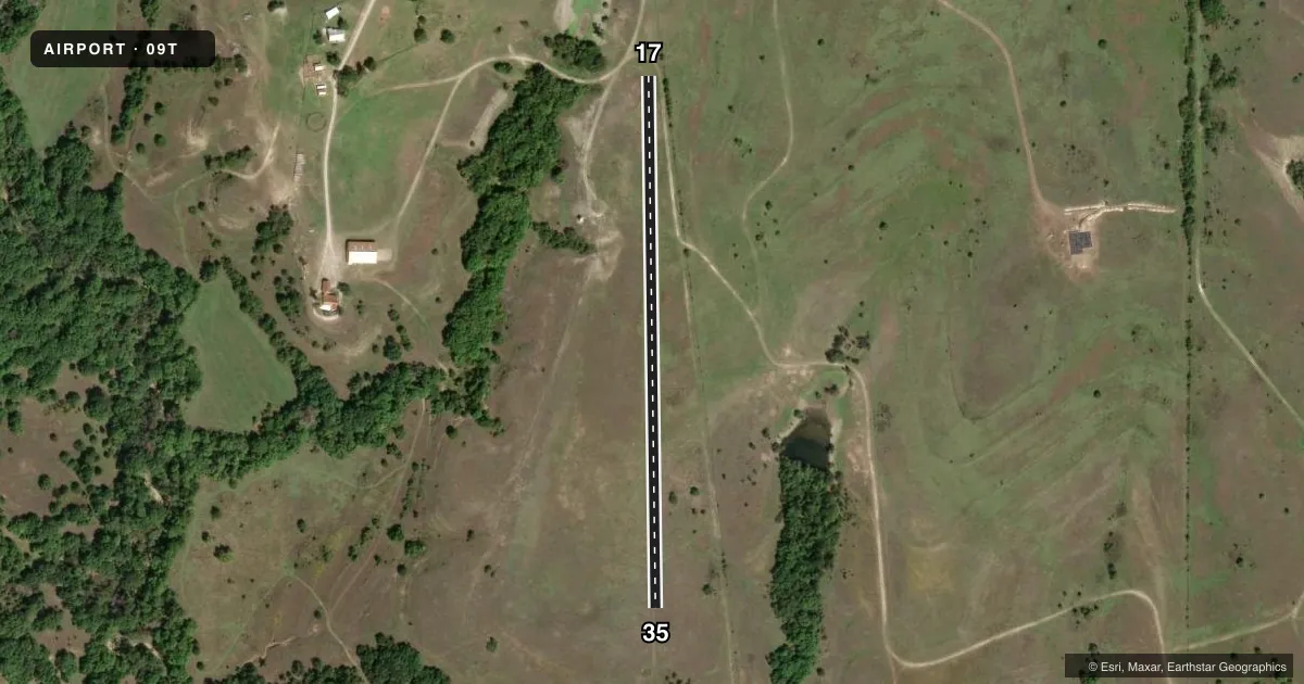
Airport sketch
Runways drawn to scale from FAA survey coordinates, rendered over satellite imagery. Not for navigation.
Approaches & charts
Services on the field
Fuel grades, oxygen, maintenance, ramp storage and lighting — as declared to the FAA by the airport operator.
Fuel & services
- Fuel
- Not available
Ramp & ground
- Transient storage
- Not published
- Wind indicator
- Yes
- Segmented circle
- No
Fuel & FBOs
Cheapest 100LL and Jet A on the field and nearby. Always confirm with the FBO before taxi.
Airport notes
Surface conditions, obstructions, local procedures, lighting outages and other notes published with each FAA cycle.
General notes
- LIVESTOCK ON & INVOF ARPT.
- FOR FLD COND CALL TO CONFIRM RWY IS CLEAR OF LIVESTOCK.
- FOR CD CTC LONE STAR APCH AT 972-615-2799.
Runway surface & condition
- 17/35CENTER 20 FT MOWED.
Approach & departure obstructions
- 1715 FT TREE AT RWY END.
Other notes
- PRVDD VFR OPNS. RIGHT TFC RY 17. TRAFFIC PATTERN ALTITUDE 500 FT AGL.
- 17/35ROUGH, ROLLING GRADIENT. NO LINE OF SIGHT BETWEEN RWY ENDS.
VFR map & nearby airports
VFR sectional. Tap any ICAO chip to open that airport.
Key facts · 09T
Answer card- ICAO
- 09T
- Name
- LAZY G BAR RANCH
- Location
- DECATUR, TEXAS
- Elevation
- 931 ft MSL
- Traffic pattern altitude
- 1,931 ft MSL (1,000 AGL)
- Control tower
- Non-towered (use CTAF)
- Total runways
- 1
- Longest runway
- 17/35 · 1,600 ft
- Published ILS approaches
- 0
- Published frequencies
- 1
- Magnetic variation
- 7°
- Current flight rules
- VFR
- Current wind
- 170° at 10 kt
- Favored runway now
- RWY 17
Lazy G Bar Ranch Airport (09T) is in Decatur, Texas. The field elevation is 931 ft MSL. It has one runway. Runway 17/35 is 1,600 ft long and surfaced turf-dirt. The airport is not towered. CTAF is 122.9.
No ILS approaches are published here. The published pattern altitude is 500 ft AGL. That puts the pattern at 1,431 ft MSL. VFR operations are provided. Right traffic is used for runway 17. The runway surface is rough with a rolling gradient. There is no line of sight between runway ends. A 15-foot tree sits at the runway 17 end. The center 20 feet of the runway is mowed.
There are no on-field FBOs listed. Call the airport operator or the field directly before arrival if you need current services. Livestock are on and near the airport. Call to confirm the runway is clear before you go in. For clearance delivery, contact Lone Star Approach at 972-615-2799. Pilots should plan for a short turf-dirt strip with limited sight picture and a field environment that can change fast.