METAR & TAF 3TX
3TX does not publish a METAR.
Showing the nearest reporting station: KDTO (DENTON ENTERPRISE) · 13.8 NM away. Conditions at 3TX may differ.
METAR · KDTO
Observed 07:53Z
KDTO 270753Z AUTO 17006KT 10SM CLR 27/20 A2994 RMK AO2 SLP125 T02720200
- Wind
- 170° @ 6 kt
- Visibility
- 10 SM
- Temp / Dew
- 27°C / 20°C
- Altimeter
- 29.94 inHg
- Clouds
- CLR
- Density alt
- 2,525 ft
- Ceiling
- Unlimited
- Rules
- VFR
Airport info & contacts
Manager on record, flight service, ARTCC, attendance schedule and pattern altitude — published by the FAA and refreshed every 28 days.
Location
- From city
- 3 NM NE
- VFR sectional
- DALLAS-FT WORTH
- ARTCC
- ZFW · FORT WORTH
- NOTAM facility
- 3TX (NOTAM-D)
Airport manager
- Name
- JULIA & TONY WOOD
- Phone
- 817-658-4569
- Address
- PO BOX 9, SLIDELL TX 76267
Flight service · Hours
- FSS FTW
- FORT WORTH1-800-WX-BRIEF
- Attendance
- IREG
Frequencies
Tap any row to copy the frequency to your clipboard.
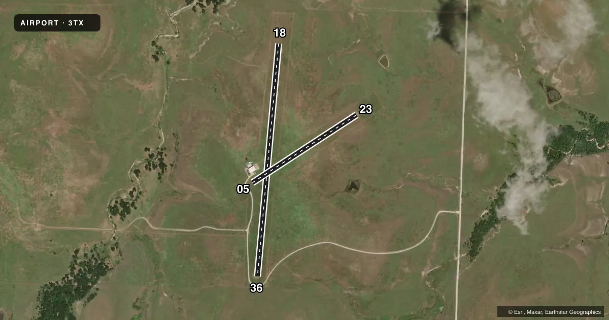
Runways & pattern
Full pagePattern entry · RWY 18
LEFT TRAFFIC| Runway | Heading (°M) | Length | Surface | Traffic |
|---|---|---|---|---|
| 18/36Favored | 185° / 5° | 3,001 ft | TURF | Standard L |
| 05/23 | 57° / 237° | 1,600 ft | TURF | Standard L |
Runway end performance
| End | TORA | TODA | ASDA | LDA | VGSI | Approach lights | Obstruction |
|---|---|---|---|---|---|---|---|
| 18 | — | — | — | — | — | — | 4', fence, 0' from thr, 117' R of cntrln, slope 1 |
| 36 | — | — | — | — | — | — | 10', road, 0' from thr, 90' R of cntrln, slope 1 |
| 05 | — | — | — | — | — | — | 4', fence, 0' from thr, 90' R of cntrln, slope 1 |
| 23 | — | — | — | — | — | — | 4', fence, 0' from thr, 121' R of cntrln, slope 1 |
Declared distances in feet. TORA = takeoff run available, TODA = takeoff distance, ASDA = accelerate-stop, LDA = landing distance.
Airport sketch
Runways drawn to scale from FAA survey coordinates, rendered over satellite imagery. Not for navigation.
Approaches & charts
Services on the field
Fuel grades, oxygen, maintenance, ramp storage and lighting — as declared to the FAA by the airport operator.
Fuel & services
- Fuel
- Not available
Ramp & ground
- Transient storage
- Not published
- Wind indicator
- Yes
Fuel & FBOs
Cheapest 100LL and Jet A on the field and nearby. Always confirm with the FBO before taxi.
Airport notes
Surface conditions, obstructions, local procedures, lighting outages and other notes published with each FAA cycle.
General notes
- APA ACROBATIC PRACTICE AREA CO-LCTD WITH THIS ARPT. INTSV AEROBATIC TRNG. PPR. CTC AMGR 24 HRS PRIOR TO ARR, 817-658-7479.
- BIRDS, COWS AND WILDLIFE INVOF RWYS.
- RADIO CTC RECOMMENDED PRIOR TO LDG FOR ADZY.
- FOR CD CTC LONE STAR APCH AT 972-615-2799.
- PPR. CTC AMGR 24 HRS PRIOR TO ARR, 817-658-7479 FOR FLD CONDS.
- ARPT FENCED & GATE LOCKED. FOR INGRESS & EGRESS, CALL 817-658-7479.
- ARPT ROLLING TRRN. ACFT NOT VSB AT OPPOSITE RWY ENDS.
- LOOSE ROCKS ON RWY. CALL FOR FICONS.
Approach & departure obstructions
- 05RWY 05/23 CORNERS MKD WITH WHITE BARRELS..
- 18RWY 18/36 CORNERS MKD WITH WHITE BARRELS.
VFR map & nearby airports
VFR sectional. Tap any ICAO chip to open that airport.
Key facts · 3TX
Answer card- ICAO
- 3TX
- Name
- AKROVILLE
- Location
- SLIDELL, TEXAS
- Elevation
- 895 ft MSL
- Traffic pattern altitude
- 1,895 ft MSL (1,000 AGL)
- Control tower
- Non-towered (use CTAF)
- Total runways
- 2
- Longest runway
- 18/36 · 3,001 ft
- Published ILS approaches
- 0
- Published frequencies
- 1
- Magnetic variation
- –
- Current flight rules
- VFR
- Current wind
- 170° at 6 kt
- Favored runway now
- RWY 18
AKROVILLE is in Slidell, Texas. The field elevation is 895 ft MSL. It has two turf runways. The longest is 18/36 at 3,001 ft. Runway 05/23 is 1,600 ft. There is no control tower. CTAF is 122.9.
No ILS approaches are published here. Pattern altitude is not published, so use the standard 1,000 ft AGL for light piston traffic unless the current Chart Supplement says otherwise. The airport sits on rolling terrain. Aircraft are not visible at opposite runway ends. That matters on short final and during taxi. Wildlife is also a factor. The published remarks mention birds, cows and other wildlife near the runways. Loose rocks are also reported on the field.
There is no on-field FBO listed. Prior permission is required before arrival. The airport is fenced and the gate is locked, so call ahead for access and current field conditions. The remarks also note active aerobatic training in a co-located practice area. Expect intensive aerobatic activity nearby. Contact the airport manager at 817-658-7479 before you go. For clearance delivery, Lone Star Approach is listed at 972-615-2799. Radio contact is recommended before landing for advisory.