METAR & TAF T38
T38 does not publish a METAR.
Showing the nearest reporting station: KDTO (DENTON ENTERPRISE) · 10.7 NM away. Conditions at T38 may differ.
METAR · KDTO
Observed 09:53Z
KDTO 270953Z AUTO 00000KT 10SM CLR 23/20 A2993 RMK AO2 SLP124 T02330200
- Wind
- 000° @ 0 kt
- Visibility
- 10 SM
- Temp / Dew
- 23°C / 20°C
- Altimeter
- 29.93 inHg
- Clouds
- CLR
- Density alt
- 1,896 ft
- Ceiling
- Unlimited
- Rules
- VFR
Airport info & contacts
Manager on record, flight service, ARTCC, attendance schedule and pattern altitude — published by the FAA and refreshed every 28 days.
Location
- From city
- 1 NM N
- VFR sectional
- DALLAS-FT WORTH
- ARTCC
- ZFW · FORT WORTH
- NOTAM facility
- FTW (NOTAM-D)
Airport manager
- Name
- DAVID "SCOTT" DUFRECHE
- Phone
- 940-453-5256
- Address
- 11544 EAGLE VIEW CIR, SANGER TX 76266-0279
Flight service · Hours
- FSS FTW
- FORT WORTH1-800-WX-BRIEF
- Attendance
- Unattended
Frequencies
Tap any row to copy the frequency to your clipboard.
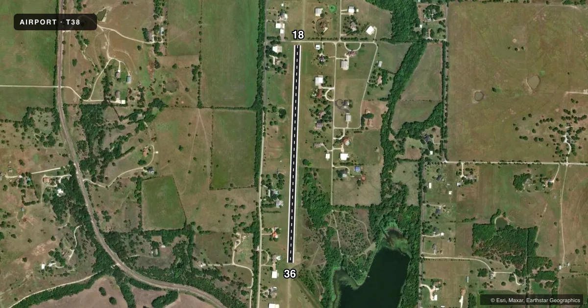
Runways & pattern
Full pagePattern entry · RWY 18
LEFT TRAFFICRunway end performance
| End | TORA | TODA | ASDA | LDA | VGSI | Approach lights | Obstruction |
|---|---|---|---|---|---|---|---|
| 18 | — | — | — | — | — | — | 10', road, 23' from thr, 125' R of cntrln, slope 2 |
| 36 | — | — | — | — | — | — | 22', trees, 375' from thr, 0' R of cntrln, slope 17 |
Declared distances in feet. TORA = takeoff run available, TODA = takeoff distance, ASDA = accelerate-stop, LDA = landing distance.
Airport sketch
Runways drawn to scale from FAA survey coordinates, rendered over satellite imagery. Not for navigation.
Approaches & charts
Services on the field
Fuel grades, oxygen, maintenance, ramp storage and lighting — as declared to the FAA by the airport operator.
Fuel & services
- Fuel
- Not available
- Oxygen (bottled)
- Not available
- Oxygen (bulk)
- Not available
- Airframe repair
- Not available
- Power plant repair
- Not available
Ramp & ground
- Transient storage
- Not published
- Landing fee
- No fee published
- Lighting schedule
- SEE RMK
- Wind indicator
- Lighted
- Segmented circle
- No
Fuel & FBOs
Cheapest 100LL and Jet A on the field and nearby. Always confirm with the FBO before taxi.
Airport notes
Surface conditions, obstructions, local procedures, lighting outages and other notes published with each FAA cycle.
General notes
- PAEW ON RWY. GRASS MOWER WILL CLEAR RWY AFT LOW APCH.
- WILDLIFE ON & INVOF RWY.
- RWY SOFT WHEN WET, CALL FOR FICONS.
- DITCH ON BOTH SIDES OF RWY MID FIELD OUTSIDE OF RWY LGTS.
- GLIDER ACTVT ON & INVOF ARPT.
- DO NOT MISTAKE NORTH END 1400 FT LONG TURF TWY AS RWY.
- FOR CD CTC LONE STAR APCH AT 972-615-2799.
- CELL TWR MIDFIELD INSIDE DOWNWIND FOR RWY 36.
- NO FUEL OR OTR SVCS AVBL.
- ARPT CLSD AT NGT TO NON-RESIDENTS.
Lighting notes
- ACTVT LIRL RWY 18/36 - 122.825.
Approach & departure obstructions
- 18APCH SLOPE 22:1 TO DSPLCD THLD.
VFR map & nearby airports
VFR sectional. Tap any ICAO chip to open that airport.
Key facts · T38
Answer card- ICAO
- T38
- Name
- BAR V K
- Location
- BOLIVAR, TEXAS
- Elevation
- 765 ft MSL
- Traffic pattern altitude
- 1,765 ft MSL (1,000 AGL)
- Control tower
- Non-towered (use CTAF)
- Total runways
- 1
- Longest runway
- 18/36 · 2,900 ft
- Published ILS approaches
- 0
- Published frequencies
- 1
- Magnetic variation
- 7°
- Current flight rules
- VFR
- Current wind
- 000° at 0 kt
- Favored runway now
- –
BAR V K is in Bolivar, Texas. Field elevation is 765 ft MSL. The airport has one runway. Runway 18/36 is 2,900 ft of turf, which is the longest runway on the field. There is no control tower. CTAF is 122.85.
No ILS approaches are published here. Pattern altitude is not published. Use the standard 1,000 ft AGL pattern for light piston operations unless the current Chart Supplement or the airport operator tells you otherwise. The published remarks matter here. There is a cell tower midfield inside the downwind for runway 36. The runway is soft when wet. There is also a ditch on both sides of the runway mid field outside the runway lights. Wildlife and glider activity are reported in and around the airport.
The field has no on-field FBOs listed. No fuel or other services are available. The airport is closed at night to non-residents. Low intensity runway lighting is available on runway 18/36. It is activated on frequency 122.825. There is also a 22 to 1 approach slope to the displaced threshold on runway 18. First-time pilots should pay close attention to the turf surface. They should also watch the tower on the downwind for 36. The north end 1,400 ft turf taxiway should not be mistaken for a runway.