METAR & TAF KDTO
Current METAR
Observed 07:53Z
KDTO 270753Z AUTO 17006KT 10SM CLR 27/20 A2994 RMK AO2 SLP125 T02720200
- Wind
- 170° @ 6 kt
- Visibility
- 10 SM
- Temp / Dew
- 27°C / 20°C
- Altimeter
- 29.94 inHg
- Clouds
- CLR
- Density alt
- 2,212 ft
- Ceiling
- Unlimited
- Rules
- VFR
Airport info & contacts
Manager on record, flight service, ARTCC, attendance schedule and pattern altitude — published by the FAA and refreshed every 28 days.
Location
- From city
- 3 NM W
- VFR sectional
- DALLAS-FT WORTH
- Pattern altitude
- 800 ft AGL · 1,443 ft MSL
- ARTCC
- ZFW · FORT WORTH
- NOTAM facility
- DTO (NOTAM-D)
Airport manager
- Name
- RYAN ADAMS
- Phone
- 940-349-7744
- Address
- 5000 AIRPORT RD, DENTON TX 76207-0207
Flight service · Hours
- FSS FTW
- FORT WORTH1-800-WX-BRIEF
- Attendance
- 0600-2200
Frequencies
Tap any row to copy the frequency to your clipboard.
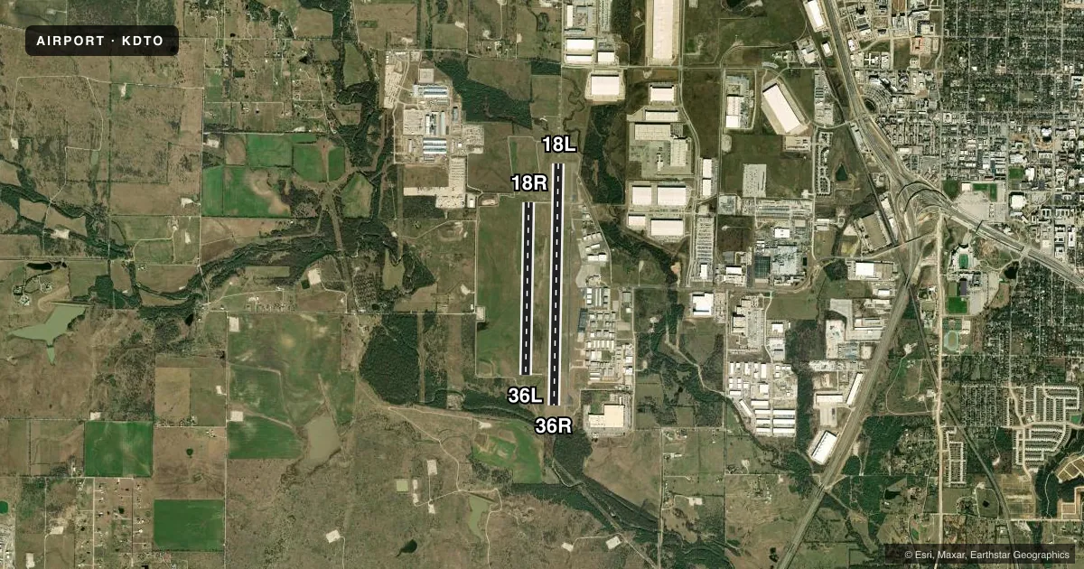
Runways & pattern
Full pagePattern entry · RWY 18L
LEFT TRAFFIC| Runway | Heading (°M) | Length | Surface | Traffic |
|---|---|---|---|---|
| 18L/36RFavored | 177° / 357° | 7,002 ft | ASPH | Standard L |
| 18R/36L | 177° / 357° | 5,003 ft | ASPH | Standard L |
Runway end performance
| End | TORA | TODA | ASDA | LDA | VGSI | Approach lights | Obstruction |
|---|---|---|---|---|---|---|---|
| 18L | 7,002' | 7,002' | 6,502' | 6,502' | PAPI 4-box left(3°) | MALSR | 20', trees, 720' from thr, 185' R of cntrln, slope 26 |
| 36R | 7,002' | 7,002' | 6,602' | 6,502' | PAPI 4-box left(3°) | — | 20', trees, 890' from thr, 250' R of cntrln, slope 34 |
| 18R | — | — | — | — | PAPI 4-box left(3°) | — | — |
| 36L | — | — | — | — | PAPI 4-box left(3°) | — | — |
Declared distances in feet. TORA = takeoff run available, TODA = takeoff distance, ASDA = accelerate-stop, LDA = landing distance.
Airport sketch
Runways drawn to scale from FAA survey coordinates, rendered over satellite imagery. Not for navigation.
Approaches & charts
ILS · 1
Services on the field
Fuel grades, oxygen, maintenance, ramp storage and lighting — as declared to the FAA by the airport operator.
Fuel & services
- Fuel
- 100LLA
- Oxygen (bottled)
- Not available
- Oxygen (bulk)
- Not available
- Airframe repair
- Major
- Power plant repair
- Major
- Other services
- AFRT,AVNCS,CHTR,INSTR,RNTL,SALES
Ramp & ground
- Transient storage
- Tie-down
- Hangar
- Landing fee
- No fee published
- Customs
- Not available
- Lighting schedule
- SEE RMK
- Beacon schedule
- SS-SR
- Beacon
- White / Green (civil land)(WG)
- Wind indicator
- Lighted
- Segmented circle
- Yes
Fuel & FBOs
Cheapest 100LL and Jet A on the field and nearby. Always confirm with the FBO before taxi.
Airport notes
Surface conditions, obstructions, local procedures, lighting outages and other notes published with each FAA cycle.
General notes
- RWY 18L DESIGNATED AS A CALM WIND RWY.
- ARPT CLSD TO ULTRALIGHTS AND GLIDERS.
- MOWING OPNS ON ARPT MAY-SEP.
- FOR CD WHEN ATCT IS CLSD CTC LONE STAR APCH AT 972-615-2799.
Lighting notes
- DUSK-DAWN WHEN ATCT CLSD, MIRL RWY 18L/36R & 18R/36L PRESET TO LOW INTST; TO INCR INTST & ACTVT MALSR RWY 18L - CTAF.
Approach & departure obstructions
- 36ROBSTN CLNC 49:1 TO DTHR OVR 20 FT TREES, 980 DSTC, 40:1 OVR LOC ANT, 600 FT DSTC.
- 18L15 FT LOCALIZER ANT, 500 FT DSTC, OBSTN CLNC 20:1, 40:1 TO DTHR.
Other notes
- MANAGERRYAN.ADAMS@CITYOFDENTON.COM
VFR map & nearby airports
VFR sectional. Tap any ICAO chip to open that airport.
Key facts · KDTO
Answer card- ICAO
- KDTO
- Name
- DENTON ENTERPRISE
- Location
- DENTON, TEXAS
- Elevation
- 642.8 ft MSL
- Traffic pattern altitude
- 1,442.8 ft MSL (800 AGL)
- Control tower
- Towered · 0600-2200
- Total runways
- 2
- Longest runway
- 18L/36R · 7,002 ft
- Published ILS approaches
- 1
- Published frequencies
- 9
- Magnetic variation
- 4°
- Current flight rules
- VFR
- Current wind
- 170° at 6 kt
- Favored runway now
- RWY 18L
Denton Enterprise Airport is in Denton, Texas. The field elevation is 642.8 ft MSL. It has two asphalt runways. The longest is 18L/36R at 7,002 ft. The tower is open daily from 0600 to 2200. One ILS approach is published for runway 18L.
Pattern altitude is 800 ft AGL. That is 1,442.8 ft MSL. Runway headings are magnetic. Both runways are aligned 181° and 1°.
Sheltair is on the field. It carries 100LL, Jet A and Jet A Prist. If you need fuel or ramp details, call them at (940) 297-6411 before you go.
A few remarks matter for a first-time arrival. Runway 18L is the calm wind runway. There are obstacle clearance notes near both ends of 18L and 36R. Pay attention to the displaced threshold picture and the localizer antenna area on short final. Mowing happens from May through September. The airport is closed to ultralights and gliders. When the tower is closed, clearance delivery goes through Lone Star Approach. For lighting after dark, the runway lights come up in low intensity by default. Use CTAF to increase intensity and to activate the medium intensity approach lighting system with runway alignment indicator lights for 18L.