METAR & TAF 30F
30F does not publish a METAR.
Showing the nearest reporting station: KDTO (DENTON ENTERPRISE) · 10.2 NM away. Conditions at 30F may differ.
METAR · KDTO
Observed 04:53Z
KDTO 270453Z AUTO 15005KT 10SM CLR 28/19 A2994 RMK AO2 SLP129 T02830189
- Wind
- 150° @ 5 kt
- Visibility
- 10 SM
- Temp / Dew
- 28°C / 19°C
- Altimeter
- 29.94 inHg
- Clouds
- CLR
- Density alt
- 2,199 ft
- Ceiling
- Unlimited
- Rules
- VFR
Airport info & contacts
Manager on record, flight service, ARTCC, attendance schedule and pattern altitude — published by the FAA and refreshed every 28 days.
Location
- From city
- 1 NM NE
- VFR sectional
- DALLAS-FT WORTH
- ARTCC
- ZFW · FORT WORTH
- NOTAM facility
- FTW (NOTAM-D)
Airport manager
- Name
- RANDY SQUIER
- Phone
- 214-850-8180
- Address
- PO BOX 356, LAKE DALLAS TX 75065
Flight service · Hours
- FSS FTW
- FORT WORTH1-800-WX-BRIEF
- Attendance
- Unattended
Frequencies
Tap any row to copy the frequency to your clipboard.
Runways & pattern
Full pagePattern entry · RWY 18L
LEFT TRAFFICRunway end performance
| End | TORA | TODA | ASDA | LDA | VGSI | Approach lights | Obstruction |
|---|---|---|---|---|---|---|---|
| 18L | — | — | — | — | — | — | 40', trees, 400' from thr, 140' R of cntrln, slope 10 |
| 36R | — | — | — | — | — | — | 22', pole, 326' from thr, 25' R of cntrln, slope 14 |
Declared distances in feet. TORA = takeoff run available, TODA = takeoff distance, ASDA = accelerate-stop, LDA = landing distance.
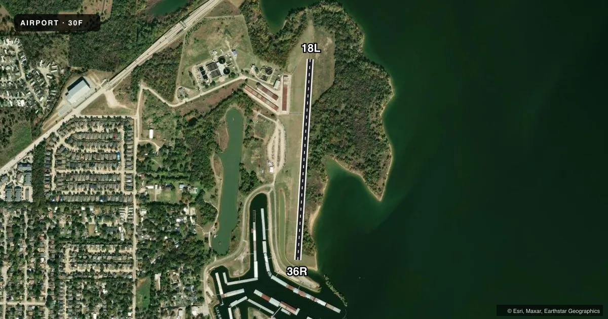
Airport sketch
Runways drawn to scale from FAA survey coordinates, rendered over satellite imagery. Not for navigation.
Approaches & charts
Services on the field
Fuel grades, oxygen, maintenance, ramp storage and lighting — as declared to the FAA by the airport operator.
Fuel & services
- Fuel
- Not available
- Oxygen (bottled)
- Not available
- Oxygen (bulk)
- Not available
Ramp & ground
- Transient storage
- Tie-down
- Landing fee
- No fee published
- Customs
- Not available
- Wind indicator
- Yes
- Segmented circle
- No
Fuel & FBOs
Cheapest 100LL and Jet A on the field and nearby. Always confirm with the FBO before taxi.
Airport notes
Surface conditions, obstructions, local procedures, lighting outages and other notes published with each FAA cycle.
General notes
- NO TGL PERMITTED.
- ARPT CLSD TO TSNT STUDENTS.
- BIRDS ON AND INVOF ARPT.
- POWERED PARACHUTES AND BALLOONS PROHIBITED.
- RWY 18L/36R LAKE 350 FT FM NORTH END OF RWY, 170 FT FM SOUTH END. PORTIONS OF RWY MAY BE UNDER WATER DURING HEAVY RAINS.
- GATE LOCKED 24 HRS.
- FOR CD CTC LONE STAR APCH AT 972-615-2799.
- RWY 36 30-50 FT TREES, 65 FT R, PARALLEL TO RWY.
- RWY 18R/36L BOATS & TRAILERS PARKED ALONG WEST EDGE OF RWY.
- RWY 18R/36L DEFINED BY MOWING. UNA TO DTRM LCTN OF RWY, NOT INSPD.
Approach & departure obstructions
- 18L20 FT TREES 60 FT DSTC, ACRS APCH.
- 36R15 FT RD 168 FT DSTC ACROSS APCH.
Other notes
- PRE-DATES THE ACT.
- OWNERARPT PROPERTY SOUTH FM S-TWY LEASED FROM U.S. GOVT-CORPS OF ENGINEERS BY LAKE DALLAS BOAT WORKS & LAKEVIEW AIRPORT; BLDG AREA & RY NORTH OF S-TWY OWNED BY LAKEVIEW ARPT.
- 18R/36LRWY PAVEMENT UNEVEN WITH LOOSE STONES, VEGETATION, & POT HOLES.
VFR map & nearby airports
VFR sectional. Tap any ICAO chip to open that airport.
Key facts · 30F
Answer card- ICAO
- 30F
- Name
- LAKEVIEW
- Location
- LAKE DALLAS, TEXAS
- Elevation
- 535 ft MSL
- Traffic pattern altitude
- 1,535 ft MSL (1,000 AGL)
- Control tower
- Non-towered (use CTAF)
- Total runways
- 1
- Longest runway
- 18L/36R · 2,600 ft
- Published ILS approaches
- 0
- Published frequencies
- 1
- Magnetic variation
- 7°
- Current flight rules
- VFR
- Current wind
- 150° at 5 kt
- Favored runway now
- RWY 18L
Lakeview Airport (30F) sits in Lake Dallas, Texas. Field elevation is 535 ft MSL. The airport has one published runway, 18L/36R, which is 2,600 ft of turf. No tower is in operation. CTAF is 122.9. No ILS approaches are published.
Pattern altitude is not published. Use the standard 1,000 ft AGL pattern unless local guidance or the current FAA Chart Supplement says otherwise. That puts the pattern at about 1,535 ft MSL based on the field elevation, but verify before you fly.
The published remarks matter here. The north end of runway 18L/36R has a lake close by. Heavy rain can leave parts of the runway underwater. There are 20-foot trees near the 18L approach. The 36R approach has a road nearby. Powered parachutes and balloons are prohibited. Touch-and-go operations are not permitted. The airport gate is locked 24 hours. Birds are also reported on and near the field.
No on-field FBOs are listed. Contact the airport operator directly before arrival, or call the field on CTAF for current fuel and service availability. The airport is closed to transient students. Pilots should also note the published runway 18R/36L reference is defined by mowing, but its location could not be confirmed. Check the current FAA Chart Supplement before operating here.