METAR & TAF 3T6
3T6 does not publish a METAR.
Showing the nearest reporting station: KDTO (DENTON ENTERPRISE) · 6.4 NM away. Conditions at 3T6 may differ.
METAR · KDTO
Observed 07:53Z
KDTO 270753Z AUTO 17006KT 10SM CLR 27/20 A2994 RMK AO2 SLP125 T02720200
- Wind
- 170° @ 6 kt
- Visibility
- 10 SM
- Temp / Dew
- 27°C / 20°C
- Altimeter
- 29.94 inHg
- Clouds
- CLR
- Density alt
- 2,289 ft
- Ceiling
- Unlimited
- Rules
- VFR
Airport info & contacts
Manager on record, flight service, ARTCC, attendance schedule and pattern altitude — published by the FAA and refreshed every 28 days.
Location
- From city
- 3 NM N
- VFR sectional
- DALLAS-FT WORTH
- ARTCC
- ZFW · FORT WORTH
- NOTAM facility
- FTW (NOTAM-D)
Airport manager
- Name
- ALLEN HILTON
- Phone
- 972-741-4520
- Address
- BOX 154627, IRVING TX 75015
Flight service · Hours
- FSS FTW
- FORT WORTH1-800-WX-BRIEF
- Attendance
- Unattended
Frequencies
Tap any row to copy the frequency to your clipboard.
Runways & pattern
Full pagePattern entry · RWY 17
LEFT TRAFFICRunway end performance
| End | TORA | TODA | ASDA | LDA | VGSI | Approach lights | Obstruction |
|---|---|---|---|---|---|---|---|
| 17 | — | — | — | — | — | — | 21', bldg, 620' from thr, 0' R of cntrln, slope 20 |
| 35 | — | — | — | — | — | — | 10', tree, 385' from thr, 42' R of cntrln, slope 18 |
Declared distances in feet. TORA = takeoff run available, TODA = takeoff distance, ASDA = accelerate-stop, LDA = landing distance.
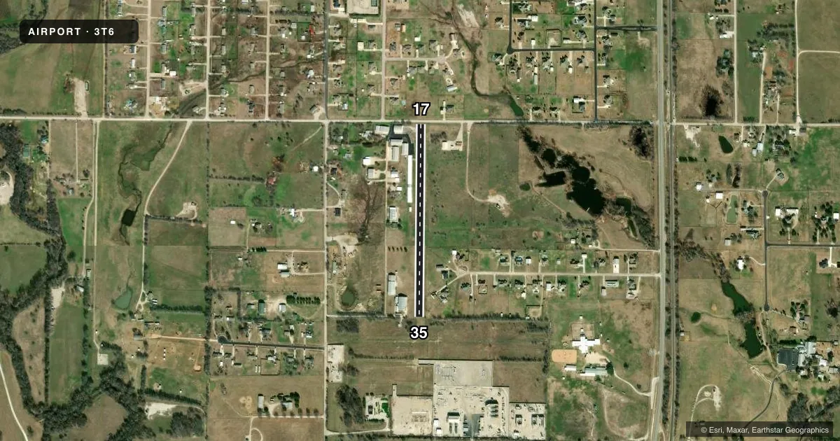
Airport sketch
Runways drawn to scale from FAA survey coordinates, rendered over satellite imagery. Not for navigation.
Approaches & charts
Services on the field
Fuel grades, oxygen, maintenance, ramp storage and lighting — as declared to the FAA by the airport operator.
Fuel & services
- Fuel
- Not available
Ramp & ground
- Transient storage
- Hangar
- Landing fee
- No fee published
- Wind indicator
- Yes
- Segmented circle
- No
Fuel & FBOs
Cheapest 100LL and Jet A on the field and nearby. Always confirm with the FBO before taxi.
Airport notes
Surface conditions, obstructions, local procedures, lighting outages and other notes published with each FAA cycle.
General notes
- 5 FT FENCE 50-75 FT EAST OF & PARALLEL TO RWY
- FOR CD CTC LONE STAR APCH AT 972-615-2799.
Approach & departure obstructions
- 1716 FT RD 150 FT DSTC, 125 FT L/R, 30 FT TREE 125 FT DSTC, 70 FT R.
- 355 FT FENCE 0 FT DSTC, 50 FT R; 15 FT TREE, 50 FT DSTC, 40 FT R.
- 17NO CNTRLN STRIPE.
- 35NO CNTRLN STRIPE.
Other notes
- COMPATIBLE TRAFFIC PATTERNS W/SHARP ARPT. NORTH THRESHOLD DSPLCD TO PROVIDE CLEARANCE OVR ROAD.
- CALL AHEAD FOR HNGR STORAGE.
- 17/35LOOSE STONES ON RWY.
VFR map & nearby airports
VFR sectional. Tap any ICAO chip to open that airport.
Key facts · 3T6
Answer card- ICAO
- 3T6
- Name
- CLARK
- Location
- JUSTIN, TEXAS
- Elevation
- 705 ft MSL
- Traffic pattern altitude
- 1,705 ft MSL (1,000 AGL)
- Control tower
- Non-towered (use CTAF)
- Total runways
- 1
- Longest runway
- 17/35 · 1,800 ft
- Published ILS approaches
- 0
- Published frequencies
- 1
- Magnetic variation
- 7°
- Current flight rules
- VFR
- Current wind
- 170° at 6 kt
- Favored runway now
- RWY 17
CLARK (3T6) is in Justin, Texas. The field elevation is 705 ft MSL. It has one runway, 17/35, which is 1,800 ft long and asphalt. The airport is non-towered. CTAF is 122.9.
No ILS approaches are published here. The pattern altitude is not published, so use the standard 1,000 ft AGL for light piston operations unless the current Chart Supplement says otherwise. Clearance delivery is handled through Lone Star Approach at 972-615-2799.
The published remarks matter here. The north threshold is displaced to give road clearance. There are loose stones on the runway. Runway 35 has no centerline stripe. Runway 17 has no centerline stripe. There is also a fence east of the runway that runs parallel to it. Obstructions are close on both ends, so brief your approach and rollout carefully.
No on-field FBOs are listed in the facts. Call the airport operator directly before arrival if you need hangar storage. First-time pilots should pay close attention to the short runway, the displaced threshold and the nearby obstacles. Confirm current runway condition and any local procedures before you go.