METAR & TAF 74T
74T does not publish a METAR.
Showing the nearest reporting station: KDTO (DENTON ENTERPRISE) · 3.0 NM away. Conditions at 74T may differ.
METAR · KDTO
Observed 04:53Z
KDTO 270453Z AUTO 15005KT 10SM CLR 28/19 A2994 RMK AO2 SLP129 T02830189
- Wind
- 150° @ 5 kt
- Visibility
- 10 SM
- Temp / Dew
- 28°C / 19°C
- Altimeter
- 29.94 inHg
- Clouds
- CLR
- Density alt
- 2,434 ft
- Ceiling
- Unlimited
- Rules
- VFR
Airport info & contacts
Manager on record, flight service, ARTCC, attendance schedule and pattern altitude — published by the FAA and refreshed every 28 days.
Location
- From city
- 2 NM E
- VFR sectional
- DALLAS-FT WORTH
- ARTCC
- ZFW · FORT WORTH
- NOTAM facility
- FTW (NOTAM-D)
Airport manager
- Name
- MARK HICKS
- Phone
- 940-479-2114
- Address
- 7420 FM 2449, PONDER TX 76259
Flight service · Hours
- FSS FTW
- FORT WORTH1-800-WX-BRIEF
- Attendance
- Unattended
Frequencies
Tap any row to copy the frequency to your clipboard.
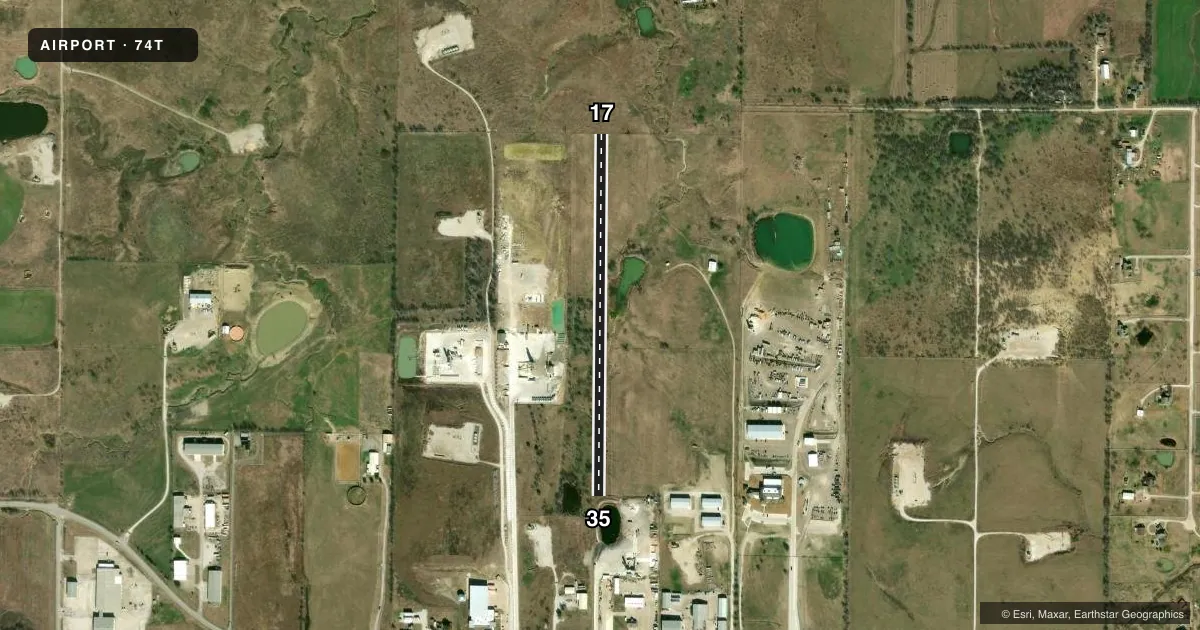
Runways & pattern
Full pagePattern entry · RWY 17
RIGHT TRAFFICRunway end performance
| End | TORA | TODA | ASDA | LDA | VGSI | Approach lights | Obstruction |
|---|---|---|---|---|---|---|---|
| 17 | — | — | — | — | — | — | 15', bldg, 0' from thr, 40' R of cntrln, slope 0 |
| 35 | — | — | — | — | — | — | 20', fence, 0' from thr, 30' R of cntrln, slope 0 |
Declared distances in feet. TORA = takeoff run available, TODA = takeoff distance, ASDA = accelerate-stop, LDA = landing distance.
Airport sketch
Runways drawn to scale from FAA survey coordinates, rendered over satellite imagery. Not for navigation.
Approaches & charts
Services on the field
Fuel grades, oxygen, maintenance, ramp storage and lighting — as declared to the FAA by the airport operator.
Fuel & services
- Fuel
- Not available
Ramp & ground
- Transient storage
- Not published
- Segmented circle
- No
Fuel & FBOs
Cheapest 100LL and Jet A on the field and nearby. Always confirm with the FBO before taxi.
Airport notes
Surface conditions, obstructions, local procedures, lighting outages and other notes published with each FAA cycle.
General notes
- TFC IN THE PAT SHALL REMAIN AT OR BLW 1300 FT MSL.
- RWY DEFINED BY MOWING.
- 30 FT TREES, 40 FT R AND L OF RWY CNTRLN.
- 6 FT WASHOUT ALONG W SIDE OF RWY.
- RWY ROUGH & UNEVEN.
- FOR CD CTC LONE STAR APCH AT 972-615-2799.
- ARPT FENCED. GATES LOCKED. NO PUBLIC INGRESS OR EGRESS.
Approach & departure obstructions
- 17APPROACH SLOPE 7:1 TO 70 FT BLDG 510 DSTC, 170 FT R; 0:1 OVER 30 FT TREES AT RWY END. 4 FT. FENCE AT RWY END, APPROACH SLOPE 0:1.
- 17ALSO 4 FT FENCE & 30 FT TREES AT RWY END, 0:1.
Other notes
- 17/35RWY SOFT WHEN WET
VFR map & nearby airports
VFR sectional. Tap any ICAO chip to open that airport.
Key facts · 74T
Answer card- ICAO
- 74T
- Name
- HICKS
- Location
- PONDER, TEXAS
- Elevation
- 725 ft MSL
- Traffic pattern altitude
- 1,725 ft MSL (1,000 AGL)
- Control tower
- Non-towered (use CTAF)
- Total runways
- 1
- Longest runway
- 17/35 · 2,364 ft
- Published ILS approaches
- 0
- Published frequencies
- 1
- Magnetic variation
- 7°
- Current flight rules
- VFR
- Current wind
- 150° at 5 kt
- Favored runway now
- RWY 17
Hicks Airport (74T) sits in Ponder, Texas. The field elevation is 725 ft MSL. It has one runway, 17/35, which is 2,364 ft long and turf. There is no control tower. CTAF is 122.9. No ILS approaches are published.
The traffic pattern is published at or below 1,300 ft MSL. That puts the pattern about 575 ft AGL based on the field elevation. The runway is marked by mowing. The surface is rough and uneven. It is also soft when wet. Plan for a careful rollout and keep a close eye on braking and directional control.
Published remarks call out several obstacles near the runway. There are 30-foot trees close to the centerline. There is also a 4-foot fence at the runway end. The approach to runway 17 has a steep obstacle environment near the threshold. A 6-foot washout runs along the west side of the runway. The airport is fenced. Gates are locked. There is no public ingress or egress. For clearance delivery, contact Lone Star Approach at 972-615-2799. No on-field FBOs are listed, so verify services with the airport operator or the field by phone before you go.