METAR & TAF 16X
16X does not publish a METAR.
Showing the nearest reporting station: KAFW (PEROT FLD/FORT WORTH ALLIANCE) · 5.8 NM away. Conditions at 16X may differ.
METAR · KAFW
Observed 06:53Z
KAFW 270653Z 18010KT 10SM CLR 30/19 A2994 RMK AO2 SLP118 T03000189 $
- Wind
- 180° @ 10 kt
- Visibility
- 10 SM
- Temp / Dew
- 30°C / 19°C
- Altimeter
- 29.94 inHg
- Clouds
- CLR
- Density alt
- 2,772 ft
- Ceiling
- Unlimited
- Rules
- VFR
Airport info & contacts
Manager on record, flight service, ARTCC, attendance schedule and pattern altitude — published by the FAA and refreshed every 28 days.
Location
- From city
- 3 NM W
- VFR sectional
- DALLAS-FT WORTH
- ARTCC
- ZFW · FORT WORTH
- NOTAM facility
- FTW (NOTAM-D)
Airport manager
- Name
- RUSSELL SHERWOOD
- Phone
- 713-542-9570
- Address
- 15851 GUY JAMES ROAD, JUSTIN TX 76247
Flight service · Hours
- FSS FTW
- FORT WORTH1-800-WX-BRIEF
- Attendance
- Unattended
Frequencies
Tap any row to copy the frequency to your clipboard.
Runways & pattern
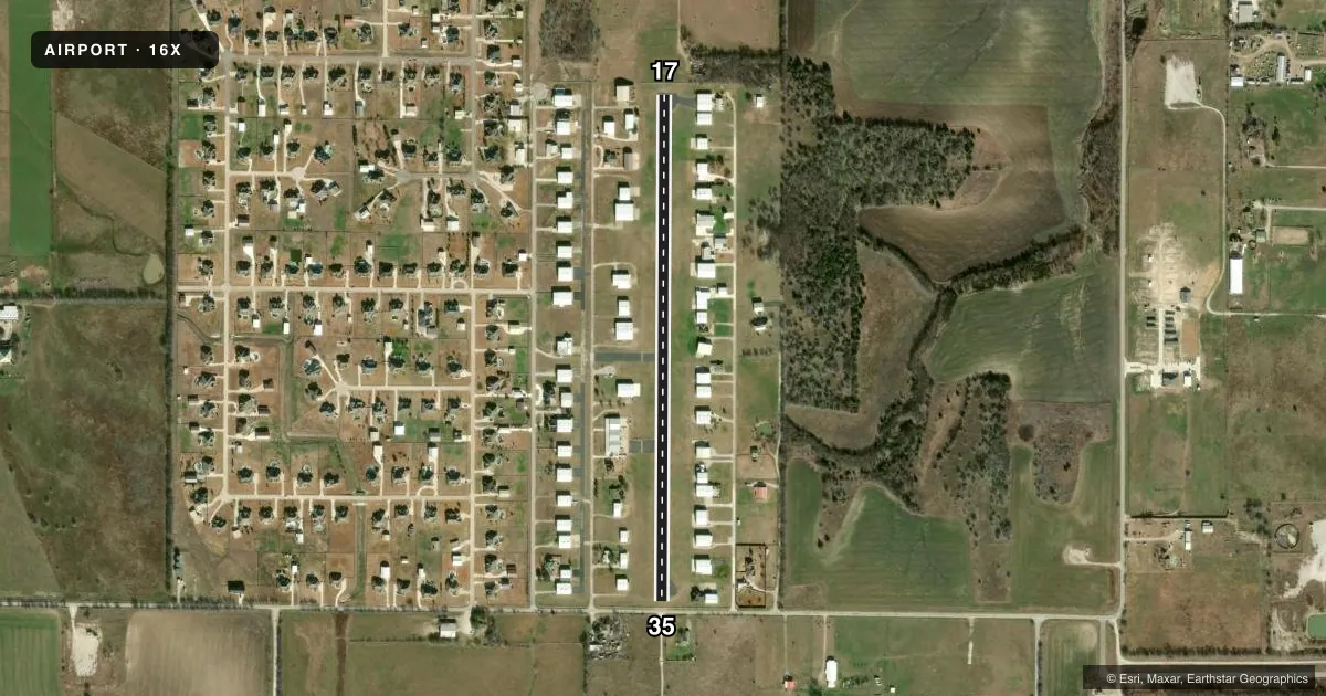
Full pagePattern entry · RWY 17
RIGHT TRAFFICRunway end performance
| End | TORA | TODA | ASDA | LDA | VGSI | Approach lights | Obstruction |
|---|---|---|---|---|---|---|---|
| 17 | — | — | — | — | — | — | 45', tree, 305' from thr, 128' R of cntrln, slope 2 |
| 35 | — | — | — | — | — | — | 25', tree, 201' from thr, 105' R of cntrln, slope 0 |
Declared distances in feet. TORA = takeoff run available, TODA = takeoff distance, ASDA = accelerate-stop, LDA = landing distance.
Airport sketch
Runways drawn to scale from FAA survey coordinates, rendered over satellite imagery. Not for navigation.
Approaches & charts
Services on the field
Fuel grades, oxygen, maintenance, ramp storage and lighting — as declared to the FAA by the airport operator.
Fuel & services
- Fuel
- Not available
Ramp & ground
- Transient storage
- Not published
- Landing fee
- No fee published
- Lighting schedule
- SEE RMK
- Beacon schedule
- SEE RMK
- Beacon
- White / Green (civil land)(WG)
- Wind indicator
- Yes
- Segmented circle
- No
Fuel & FBOs
Cheapest 100LL and Jet A on the field and nearby. Always confirm with the FBO before taxi.
Airport notes
Surface conditions, obstructions, local procedures, lighting outages and other notes published with each FAA cycle.
General notes
- FOR CD CTC LONE STAR APCH AT 972-615-2799.
Lighting notes
- ACTVT ROTG BCN - CTAF.
- ACTVT LIRL RWY 17/35 - CTAF.
Approach & departure obstructions
- 174 FT FENCE 60 FT DSTC, 130 FT L/R.
- 354 FT FENCE 70 FT DSTC AND 16 FT RD 80 FT DSTC ACRS APCH.
- 35OBSTN CLNC SLOPE 8:1 AT DSPLCD THR OVR 37 FT POLE 317 FT DSTC, 139 FT R, 152 FT L, 17:1 OVER 16 FT RD, 286 FT DSTC, 155 L/R.
Other notes
- MANAGERRSHERWOOD@VERIZON.NET
- OWNERPRESIDENT, OWNER'S ASSN.
- PRESIDENTMCEAGLE145@YAHOO.COM
VFR map & nearby airports
VFR sectional. Tap any ICAO chip to open that airport.
Key facts · 16X
Answer card- ICAO
- 16X
- Name
- PROPWASH
- Location
- JUSTIN, TEXAS
- Elevation
- 804 ft MSL
- Traffic pattern altitude
- 1,804 ft MSL (1,000 AGL)
- Control tower
- Non-towered (use CTAF)
- Total runways
- 1
- Longest runway
- 17/35 · 3,000 ft
- Published ILS approaches
- 0
- Published frequencies
- 1
- Magnetic variation
- 7°
- Current flight rules
- VFR
- Current wind
- 180° at 10 kt
- Favored runway now
- RWY 17
PROPWASH is in Justin, Texas. The field elevation is 804 ft MSL. It has one runway. Runway 17/35 is 3,000 ft long with an asphalt surface. This is an uncontrolled airport. CTAF is 122.9.
No ILS approaches are published here. The pattern altitude is not published, so use the standard 1,000 ft AGL pattern unless the current Chart Supplement says otherwise. The airport has activated low intensity runway lights on CTAF. The rotating beacon is also activated on CTAF.
There are no on-field FBOs listed in the facts. Contact the airport operator directly before arrival, or call the field on CTAF for current FBO availability. Published remarks also note obstructions near both runway ends. Runway 35 has a fence and a road close in the approach path. Runway 17 has a fence near the approach side. That makes a careful stabilized approach important, especially if you are new to the field.
If you need clearance delivery, the published remarks direct pilots to Lone Star Approach at 972-615-2799. Keep an eye on the current Chart Supplement for any updated operational notes before you go.