METAR & TAF 4T2
4T2 does not publish a METAR.
Showing the nearest reporting station: KAFW (PEROT FLD/FORT WORTH ALLIANCE) · 8.7 NM away. Conditions at 4T2 may differ.
METAR · KAFW
Observed 16:53Z
KAFW 261653Z 17009KT 10SM FEW250 34/20 A3003 RMK AO2 SLP148 T03440200 $
- Wind
- 170° @ 9 kt
- Visibility
- 10 SM
- Temp / Dew
- 34°C / 20°C
- Altimeter
- 30.03 inHg
- Clouds
- FEW
- Density alt
- 3,003 ft
- Ceiling
- Unlimited
- Rules
- VFR
Airport info & contacts
Manager on record, flight service, ARTCC, attendance schedule and pattern altitude — published by the FAA and refreshed every 28 days.
Location
- From city
- 18 NM NW
- VFR sectional
- DALLAS-FT WORTH
- ARTCC
- ZFW · FORT WORTH
- NOTAM facility
- FTW (NOTAM-D)
Airport manager
- Name
- JONATHAN OSORIO
- Phone
- 817-252-3510
- Address
- 14355 MORRIS DIDO RD, NEWARK TX 76071
Flight service · Hours
- FSS FTW
- FORT WORTH1-800-WX-BRIEF
- Attendance
- Unattended
Frequencies
Tap any row to copy the frequency to your clipboard.
Runways & pattern
Full pagePattern entry · RWY 17
LEFT TRAFFICRunway end performance
| End | TORA | TODA | ASDA | LDA | VGSI | Approach lights | Obstruction |
|---|---|---|---|---|---|---|---|
| 17 | — | — | — | — | — | — | 15', road, 201' from thr, 122' R of cntrln, slope 0 |
| 35 | — | — | — | — | — | — | 55', trees, 1180' from thr, 240' R of cntrln, slope 17 |
Declared distances in feet. TORA = takeoff run available, TODA = takeoff distance, ASDA = accelerate-stop, LDA = landing distance.
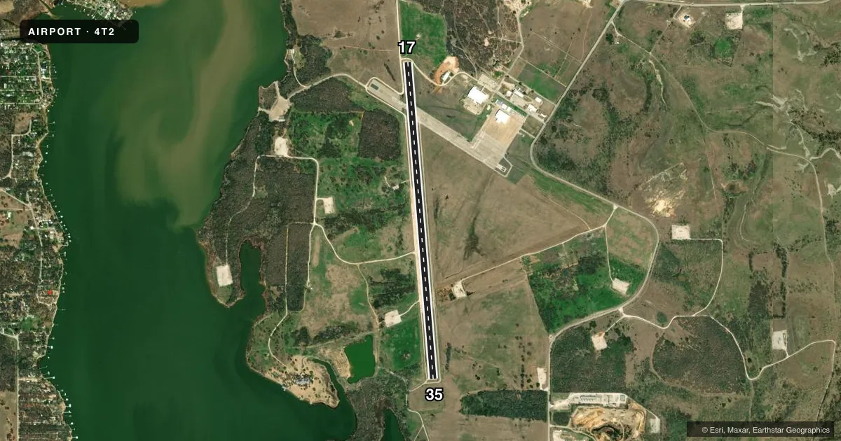
Airport sketch
Runways drawn to scale from FAA survey coordinates, rendered over satellite imagery. Not for navigation.
Approaches & charts
Services on the field
Fuel grades, oxygen, maintenance, ramp storage and lighting — as declared to the FAA by the airport operator.
Fuel & services
- Fuel
- Not available
Ramp & ground
- Transient storage
- Not published
- Landing fee
- No fee published
- Lighting schedule
- SEE RMK
- Beacon schedule
- SS-SR
- Beacon
- White / Green (civil land)(WG)
- Wind indicator
- Lighted
- Segmented circle
- No
Fuel & FBOs
Cheapest 100LL and Jet A on the field and nearby. Always confirm with the FBO before taxi.
Airport notes
Surface conditions, obstructions, local procedures, lighting outages and other notes published with each FAA cycle.
General notes
- TSNT ACFT 3 HRS PPR.
- TWY A POOR. OUTER 18 FT OF EACH SIDE IS ASPH, CENTER 39 FT IS CONC.
- EXTSV HEL ACT IN AREA.
- FOR CD CTC LONE STAR APCH AT 972-615-2799.
- 260 FT AGL TWR 0.7 NM NW RWY 17 END.
Lighting notes
- ACTVT LIRL RWY 17/35; TWY LTS - CTAF.
Approach & departure obstructions
- 1715 FT RD 0-199 FT DSTC, ACRS APCH.
- 3515 FT RD 0-120 FT DSTC ACRS APCH.
Other notes
- 17/35OUTER 50 FT OF EACH SIDE OF RWY ASPH. RWY 17 END CNTR 40 FT CONC. RWY 35 CNTR 40 FT ASPH. PAVEMENT CRACKING WITH LOOSE AGGREGATE.
VFR map & nearby airports
VFR sectional. Tap any ICAO chip to open that airport.
Key facts · 4T2
Answer card- ICAO
- 4T2
- Name
- KENNETH COPELAND
- Location
- FORT WORTH, TEXAS
- Elevation
- 693 ft MSL
- Traffic pattern altitude
- 1,693 ft MSL (1,000 AGL)
- Control tower
- Non-towered (use CTAF)
- Total runways
- 1
- Longest runway
- 17/35 · 5,943 ft
- Published ILS approaches
- 0
- Published frequencies
- 4
- Magnetic variation
- 4°
- Current flight rules
- VFR
- Current wind
- 170° at 9 kt
- Favored runway now
- RWY 17
Kenneth Copeland Airport (4T2) sits in Fort Worth, Texas. Field elevation is 693 ft MSL. The airport has one runway, 17/35, which is 5,943 ft long on asphalt and concrete. There is no control tower. Pattern altitude is not published, so use the standard 1,000 ft AGL for light piston traffic unless the current Chart Supplement says otherwise.
No ILS approaches are published here. For clearance delivery, contact Lone Star Approach at 972-615-2799. CTAF and UNICOM are both 123.075. Low intensity runway lights are available on Runway 17/35. Taxiway lighting is controlled on the CTAF.
This field has some operational details that matter on a first visit. Transient aircraft require three hours prior permission. Taxiway A is reported in poor condition. The runway surface has mixed materials, with asphalt on the outer portions and concrete in the center sections. The Runway 35 end has cracking and loose aggregate. There is a 260 ft AGL tower 0.7 NM northwest of the Runway 17 end. There is also extensive helicopter activity in the area. No on-field FBOs are listed, so verify services with the airport operator or call the field directly before arrival.