METAR & TAF KFTW
Current METAR
Observed 08:53Z
KFTW 270853Z 19009KT 10SM CLR 28/20 A2993 RMK AO2 SLP120 T02780200 $
- Wind
- 190° @ 9 kt
- Visibility
- 10 SM
- Temp / Dew
- 28°C / 20°C
- Altimeter
- 29.93 inHg
- Clouds
- CLR
- Density alt
- 2,428 ft
- Ceiling
- Unlimited
- Rules
- VFR
Airport info & contacts
Manager on record, flight service, ARTCC, attendance schedule and pattern altitude — published by the FAA and refreshed every 28 days.
Location
- From city
- 5 NM N
- VFR sectional
- DALLAS-FT WORTH
- ARTCC
- ZFW · FORT WORTH
- NOTAM facility
- FTW (NOTAM-D)
Airport manager
- Name
- AARON BARTH
- Phone
- 817 392-5400
- Address
- 201 AMERICAN CONCOURSE, SUITE 330, FORT WORTH TX 76106-2749
Flight service · Hours
- FSS FTW
- FORT WORTH1-800-WX-BRIEF
- Attendance
- ALL
Frequencies
Tap any row to copy the frequency to your clipboard.
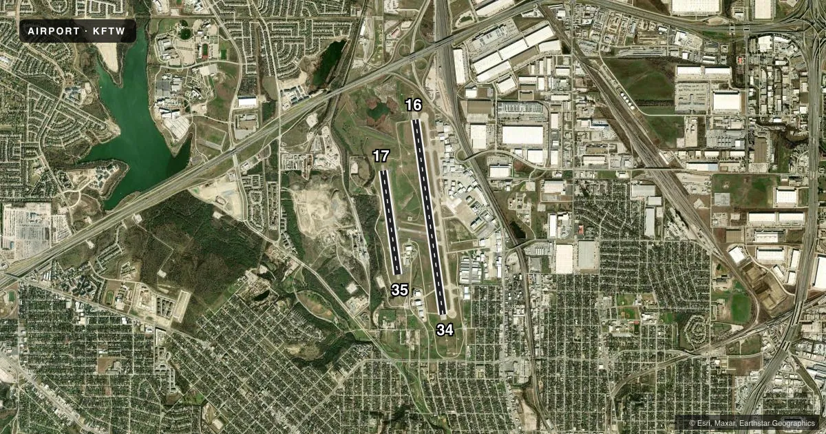
Runways & pattern
Full pagePattern entry · RWY 16
LEFT TRAFFIC| Runway | Heading (°M) | Length | Surface | Traffic |
|---|---|---|---|---|
| 16/34Favored | 164° / 344° | 7,502 ft | CONC | 34 R |
| 17/35 | 164° / 344° | 4,005 ft | ASPH | 17 R |
Runway end performance
| End | TORA | TODA | ASDA | LDA | VGSI | Approach lights | Obstruction |
|---|---|---|---|---|---|---|---|
| 16 | 7,502' | 7,502' | 7,502' | 7,502' | PAPI 4-box right(3°) | MALSR | 31', pole, 1450' from thr, 625' R of cntrln, slope 40 |
| 34 | 7,502' | 7,502' | 7,306' | 7,306' | — | MALS | — |
| 17 | — | — | — | — | PAPI 2-box left(3.75°) | — | 39', berm, 1361' from thr, 1' R of cntrln, slope 29 |
| 35 | — | — | — | — | PAPI 2-box left(3.25°) | — | — |
Declared distances in feet. TORA = takeoff run available, TODA = takeoff distance, ASDA = accelerate-stop, LDA = landing distance.
Airport sketch
Runways drawn to scale from FAA survey coordinates, rendered over satellite imagery. Not for navigation.
Approaches & charts
ILS · 2
Services on the field
Fuel grades, oxygen, maintenance, ramp storage and lighting — as declared to the FAA by the airport operator.
Fuel & services
- Fuel
- 100LLAA1+
- Oxygen (bottled)
- High pressure
- Oxygen (bulk)
- High pressure
- Airframe repair
- Major
- Power plant repair
- Major
- Other services
- AMB,AVNCS,CHTR,INSTR,RNTL,SALES,SURV
Ramp & ground
- Transient storage
- Tie-down
- Hangar
- Landing fee
- No fee published
- Customs
- Not available
- Lighting schedule
- SS-SR
- Beacon schedule
- SS-SR
- Beacon
- White / Green (civil land)(WG)
- Wind indicator
- Lighted
- Segmented circle
- Yes
Fuel & FBOs
Cheapest 100LL and Jet A on the field and nearby. Always confirm with the FBO before taxi.
Airport notes
Surface conditions, obstructions, local procedures, lighting outages and other notes published with each FAA cycle.
General notes
- BIRDS ON & INVOF ARPT.
- TWYS B, B1, C, AND D WEST OF RWY 16/34, M EAST OF TWY A, TWYS H, J, L, L1, S, W, AND TWY G SE 650 FEET CLSD TO ACFT WITH MORE THAN 30 PSGR SEATS.
- RWY 17/35 DESIGNED FOR ACFT WITH WINGSPAN OF 49 FT OR LESS. TWYS B & B1 DESIGNED FOR ACFT WITH WINGSPAN OF LESS THAN 79 FT. RY 16/34 & TWYS A, A1, AND M DESIGNED FOR ACFT WITH WINGSPAN LESS THAN 171 FT. ALL OTHER TWYS DESIGNED FOR ACFT WITH WINGSPAN OF LESS THAN 118 FT.
- H1 & H2 HELIPADS ARE VMC DALGT USE ONLY; NON-MOVEMENT AREA.
- MKD US CUST PRKG SOUTHEAST OF TXL G AND TXL N INTXN.
- HELO SKIDDING OPNS PROHIBITED ON RWY 17/35. IF SKIDDING IS RQRD, COORD WITH ATCT TO USE TWY B.
- PPR FOR ACR OPNS WITH MORE THAN 30 PSGR SEATS - 24 HR NOTICE RQRD - CALL ARPT OPS 817-994-0653.
- ARPT FEES FOR USE OF CUST SVCS WILL BE COLLD IMT UPON LDG BY CITY OF FORT WORTH ARPT OPNS PSNL.
- RWY 17/35 LED LGT CAN APPR BRGTR THAN RWY 16/34; ENSURE COR RWY ALNMT.
- HELS REPOSITIONING BYD IMT PRKG APRON AND UNDER THEIR OWN PWR MUST CTC ATC.
- ARFF INDEX B AVBL ALL USERS WITH 24 HR PPR.
Runway surface & condition
- 16/34PCR VALUE: 310/R/C/W/T
- 17/35PCR VALUE: 100/F/C/X/T
- 17/35RWY 17/35 NOT AVBL FOR PART 121/PART 380 OPS WITH SKED PAX CARRYING OPS MORE THAN 9 PAX SEATS AND NON-SKED PAX CARRYING OPS MORE THAN 30 PAX SEATS.
Other notes
- TPA - RWY 17/35 R/W 1300(590) AGL, F/W 1500(790) AGL, RWY 16/34 1500(790) AGL, JETS 2000(1290) AGL.
VFR map & nearby airports
VFR sectional. Tap any ICAO chip to open that airport.
Key facts · KFTW
Answer card- ICAO
- KFTW
- Name
- FORT WORTH MEACHAM INTL
- Location
- FORT WORTH, TEXAS
- Elevation
- 710.1 ft MSL
- Traffic pattern altitude
- 1,710.1 ft MSL (1,000 AGL)
- Control tower
- Towered · 24
- Total runways
- 2
- Longest runway
- 16/34 · 7,502 ft
- Published ILS approaches
- 2
- Published frequencies
- 11
- Magnetic variation
- 8°
- Current flight rules
- VFR
- Current wind
- 190° at 9 kt
- Favored runway now
- RWY 16
Fort Worth Meacham Intl is in Fort Worth, Texas. The field elevation is 710.1 ft MSL. It has 2 runways. The longest is runway 16/34 at 7,502 ft. The tower is open 24 hours. Two ILS approaches are published for runway ends 16 and 34. Pattern altitude is not published in the facts. Use 1,000 ft AGL for light piston traffic unless ATC or the current Chart Supplement says otherwise.
This is a busy towered field with mixed traffic. Runway 16/34 is the main runway. Runway 17/35 is shorter at 4,005 ft. The published remarks say runway 17/35 has several use limits for larger aircraft. It is also designed for aircraft with a 49 ft wingspan or less. Runway 17/35 LED lighting can appear brighter than runway 16/34, so verify alignment before landing.
Modern Aviation is on the field. It carries 100LL and Jet A. Texas Jet is also on the field. It carries 100LL and Jet A Prist. Published remarks also note airport operations coordination for larger passenger aircraft, plus customs fees collected on landing by airport operations personnel. Check the current Chart Supplement for any noise or curfew restrictions before flying into the field.