METAR & TAF 35X
35X does not publish a METAR.
Showing the nearest reporting station: KLUD (DECATUR MUNI) · 1.4 NM away. Conditions at 35X may differ.
METAR · KLUD
Observed 05:55Z
KLUD 270555Z AUTO 18010KT 10SM CLR 29/18 A2996 RMK AO2 10363 20287
- Wind
- 180° @ 10 kt
- Visibility
- 10 SM
- Temp / Dew
- 29°C / 18°C
- Altimeter
- 29.96 inHg
- Clouds
- CLR
- Density alt
- 2,883 ft
- Ceiling
- Unlimited
- Rules
- VFR
Airport info & contacts
Manager on record, flight service, ARTCC, attendance schedule and pattern altitude — published by the FAA and refreshed every 28 days.
Location
- From city
- 2 NM NE
- VFR sectional
- DALLAS-FT WORTH
- ARTCC
- ZFW · FORT WORTH
- NOTAM facility
- FTW (NOTAM-D)
Airport manager
- Name
- SAMUEL BISHOP
- Phone
- 940-627-6800
- Address
- 111 PRIVATE ROAD 2218, DECATUR TX 76234
Flight service · Hours
- FSS FTW
- FORT WORTH1-800-WX-BRIEF
- Attendance
- Unattended
Frequencies
Tap any row to copy the frequency to your clipboard.
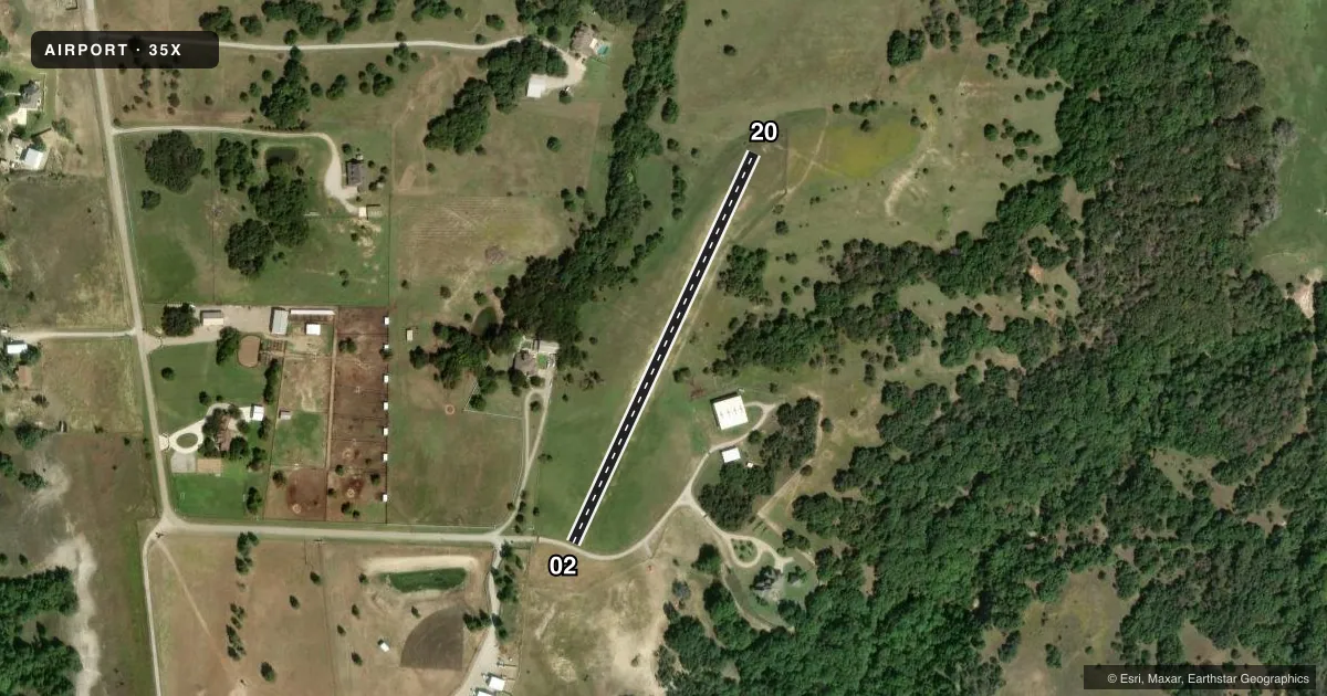
Runways & pattern
Full pagePattern entry · RWY 20
LEFT TRAFFICRunway end performance
| End | TORA | TODA | ASDA | LDA | VGSI | Approach lights | Obstruction |
|---|---|---|---|---|---|---|---|
| 02 | — | — | — | — | — | — | 10', road, 20' from thr, 135' R of cntrln, slope 2 |
| 20 | — | — | — | — | — | — | 4', fence, 10' from thr, 126' R of cntrln, slope 2 |
Declared distances in feet. TORA = takeoff run available, TODA = takeoff distance, ASDA = accelerate-stop, LDA = landing distance.
Airport sketch
Runways drawn to scale from FAA survey coordinates, rendered over satellite imagery. Not for navigation.
Approaches & charts
Services on the field
Fuel grades, oxygen, maintenance, ramp storage and lighting — as declared to the FAA by the airport operator.
Fuel & services
- Fuel
- Not available
Ramp & ground
- Transient storage
- Not published
- Wind indicator
- Yes
- Segmented circle
- No
Fuel & FBOs
Cheapest 100LL and Jet A on the field and nearby. Always confirm with the FBO before taxi.
Airport notes
Surface conditions, obstructions, local procedures, lighting outages and other notes published with each FAA cycle.
General notes
- ACFT OPRG INTO OR OUT OF ARPT WILL USE DECATUR ARPT FREQ 122.8 TO COMMUNICATE WITH DECATUR ARPT TFC.
- RWY SOFT AFT RAIN. CALL FOR FICONS.
- RWY SOFT AFTR RAIN, CALL FOR FICONS.
- NO STUDENT TRNG.
VFR map & nearby airports
VFR sectional. Tap any ICAO chip to open that airport.
Key facts · 35X
Answer card- ICAO
- 35X
- Name
- TRIPLE-ACE FLD
- Location
- DECATUR, TEXAS
- Elevation
- 1,010 ft MSL
- Traffic pattern altitude
- 2,010 ft MSL (1,000 AGL)
- Control tower
- Non-towered (use CTAF)
- Total runways
- 1
- Longest runway
- 02/20 · 1,271 ft
- Published ILS approaches
- 0
- Published frequencies
- 1
- Magnetic variation
- –
- Current flight rules
- VFR
- Current wind
- 180° at 10 kt
- Favored runway now
- RWY 20
TRIPLE-ACE FLD is in Decatur, Texas. The field elevation is 1,010 ft MSL. It has one runway. Runway 02/20 is 1,271 ft of turf, so plan for a short-field setup and check the surface before you go. The airport is uncontrolled. Use CTAF 122.8 for traffic calls. No ILS approaches are published here.
The pattern altitude is not published. Use the standard 1,000 ft AGL pattern unless the current FAA Chart Supplement or local traffic calls say otherwise. The published remarks also matter here. No student training is permitted. The runway can get soft after rain, so call for field conditions before departure or arrival. That is especially important on a turf strip with a short runway.
There are no on-field FBOs listed. Contact the airport operator directly before arrival if you need current field status or services. For a first-time pilot, the main things to watch are the turf condition, the short runway length and the lack of published instrument approaches. Treat it as a VFR planning airport and verify current conditions before you launch.