METAR & TAF KLUD
Current METAR
Observed 10:15Z
KLUD 271015Z AUTO 19007KT 150V210 10SM CLR 26/19 A2994 RMK AO2
- Wind
- 190° @ 7 kt
- Visibility
- 10 SM
- Temp / Dew
- 26°C / 19°C
- Altimeter
- 29.94 inHg
- Clouds
- CLR
- Density alt
- 2,593 ft
- Ceiling
- Unlimited
- Rules
- VFR
Airport info & contacts
Manager on record, flight service, ARTCC, attendance schedule and pattern altitude — published by the FAA and refreshed every 28 days.
Location
- From city
- 2 NM N
- VFR sectional
- DALLAS-FT WORTH
- ARTCC
- ZFW · FORT WORTH
- NOTAM facility
- LUD (NOTAM-D)
Airport manager
- Name
- GREG HALL
- Phone
- 940-627-2855
- Address
- 351 AIRPORT ROAD, DECATUR TX 76234
Flight service · Hours
- FSS FTW
- FORT WORTH1-800-WX-BRIEF
- Attendance
- 0800-1700
Frequencies
Tap any row to copy the frequency to your clipboard.
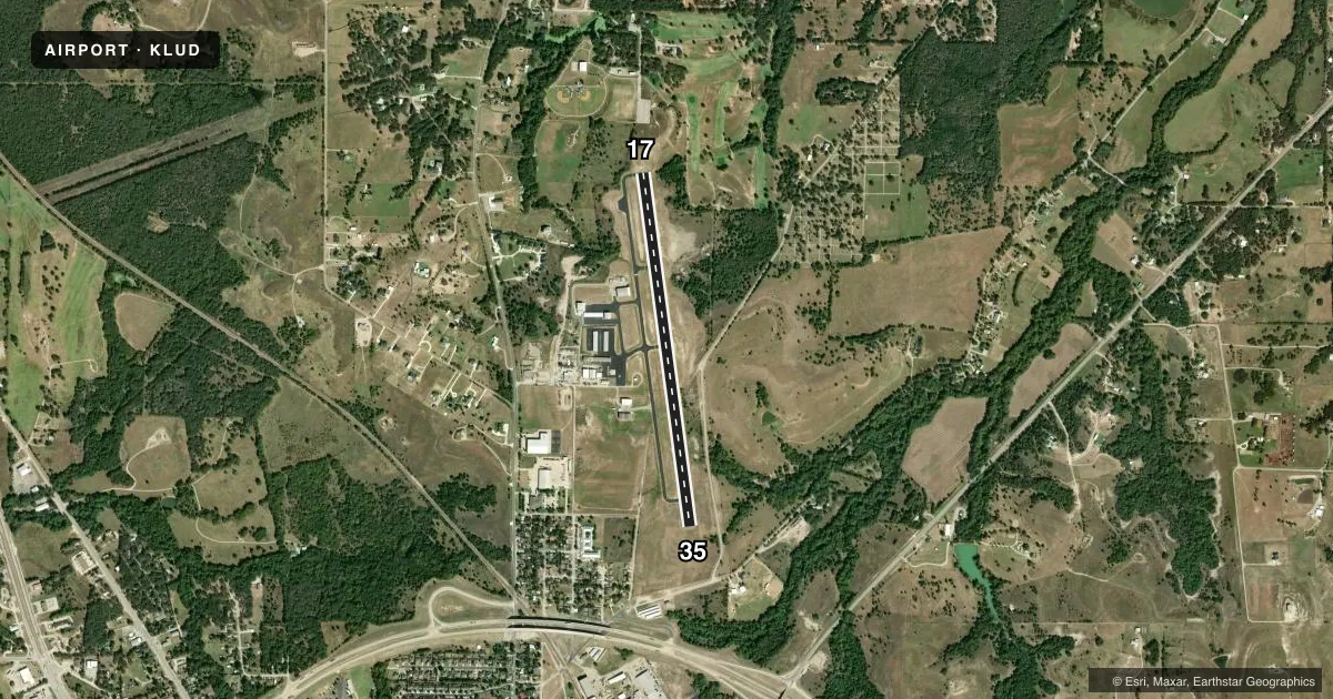
Runways & pattern
Full pagePattern entry · RWY 17
LEFT TRAFFICRunway end performance
| End | TORA | TODA | ASDA | LDA | VGSI | Approach lights | Obstruction |
|---|---|---|---|---|---|---|---|
| 17 | — | — | — | — | PAPI 2-box left(3.5°) | — | 10', tree, 243' from thr, 125' R of cntrln, slope 4 |
| 35 | — | — | — | — | PAPI 2-box left(3.5°) | — | 28', pline, 760' from thr, 230' R of cntrln, slope 20 |
Declared distances in feet. TORA = takeoff run available, TODA = takeoff distance, ASDA = accelerate-stop, LDA = landing distance.
Airport sketch
Runways drawn to scale from FAA survey coordinates, rendered over satellite imagery. Not for navigation.
Approaches & charts
Services on the field
Fuel grades, oxygen, maintenance, ramp storage and lighting — as declared to the FAA by the airport operator.
Fuel & services
- Fuel
- 100LLA
- Oxygen (bulk)
- Not available
- Airframe repair
- Major
- Power plant repair
- Major
- Other services
- INSTR,RNTL,SALES
Ramp & ground
- Transient storage
- Tie-down
- Hangar
- Landing fee
- No fee published
- Customs
- Not available
- Lighting schedule
- SEE RMK
- Beacon schedule
- SS-SR
- Beacon
- White / Green (civil land)(WG)
- Wind indicator
- Lighted
- Segmented circle
- Yes
Fuel & FBOs
Cheapest 100LL and Jet A on the field and nearby. Always confirm with the FBO before taxi.
Airport notes
Surface conditions, obstructions, local procedures, lighting outages and other notes published with each FAA cycle.
General notes
- GND DROPS SHARPLY 160 FT NORTH OF RWY 17 THR.
- DEER AND WILDLIFE ON & INVOF ARPT.
- FOR CD CTC LONE STAR APCH AT 972-615-2799.
- DUE TO RWY ELEV CHG, ACFT NOT VSB AT OPPOSITE END.
Lighting notes
- DUSK-DAWN. MIRL RWY 17/35 PRESET LOW INTST; TO INCR INTST ACTVT - CTAF.
Approach & departure obstructions
- 1730 FT TREES, 0-199 FT DSTC, 245 FT L, 151 FT R.
- 3520 FT TREES, 140-199 FT DSTC, 150-250 FT R.
- 17ALSO 30 FT MKD PLINE, 770 FT DSTC, ACRS APCH.
Other notes
- MANAGERDIR OF PUBLIC WORKS/AMGR ADDNL PHONE: 940-393-0262.
VFR map & nearby airports
VFR sectional. Tap any ICAO chip to open that airport.
Key facts · KLUD
Answer card- ICAO
- KLUD
- Name
- DECATUR MUNI
- Location
- DECATUR, TEXAS
- Elevation
- 1,046.7 ft MSL
- Traffic pattern altitude
- 2,046.7 ft MSL (1,000 AGL)
- Control tower
- Non-towered (use CTAF)
- Total runways
- 1
- Longest runway
- 17/35 · 4,200 ft
- Published ILS approaches
- 0
- Published frequencies
- 4
- Magnetic variation
- 3°
- Current flight rules
- VFR
- Current wind
- 190° at 7 kt
- Favored runway now
- RWY 17
Decatur Muni sits in Decatur, Texas. Field elevation is 1,046.7 ft MSL. The airport has one runway, 17/35, which is 4,200 ft long with asphalt pavement. There is no control tower. No ILS approaches are published. The pattern altitude is not published, so use the standard 1,000 ft AGL for light piston traffic unless the current Chart Supplement says otherwise.
Decatur Jet Center is on the field. It carries 100LL and Jet A. Call them at (940) 627-1050 for current service details. CTAF is 122.8. UNICOM is also 122.8. Lone Star Approach is listed on 118.1 and 306.95 for approach and departure work. For clearance delivery, the published contact is Lone Star Approach at 972-615-2799.
This is a field where the runway environment deserves attention. The published remarks note a marked 30-foot power line across the approach to runway 17. Trees are also close to both runway ends. The ground drops sharply north of the runway 17 threshold. Aircraft are not visible from the opposite end because of the runway elevation change. Deer and other wildlife are reported on and near the airport. From dusk to dawn, the runway lights are preset to low intensity. Use the CTAF to increase intensity if needed.