METAR & TAF F14
F14 does not publish a METAR.
Showing the nearest reporting station: KSPS (SHEPPARD AFB/WICHITA FALLS MUNI) · 6.7 NM away. Conditions at F14 may differ.
METAR · KSPS
Observed 07:52Z
KSPS 270752Z 18009KT 10SM CLR 27/18 A2990 RMK AO2 SLP108 T02670178 $
- Wind
- 180° @ 9 kt
- Visibility
- 10 SM
- Temp / Dew
- 27°C / 18°C
- Altimeter
- 29.90 inHg
- Clouds
- CLR
- Density alt
- 2,711 ft
- Ceiling
- Unlimited
- Rules
- VFR
Airport info & contacts
Manager on record, flight service, ARTCC, attendance schedule and pattern altitude — published by the FAA and refreshed every 28 days.
Location
- From city
- 8 NM NW
- VFR sectional
- DALLAS-FT WORTH
- ARTCC
- ZFW · FORT WORTH
- NOTAM facility
- FTW (NOTAM-D)
Airport manager
- Name
- JOHN HOOKER
- Phone
- 940-781-7246
- Address
- 2926 HAWS ROAD, IOWA PARK TX 76367
Flight service · Hours
- FSS FTW
- FORT WORTH1-800-WX-BRIEF
- Attendance
- Unattended
Frequencies
Tap any row to copy the frequency to your clipboard.
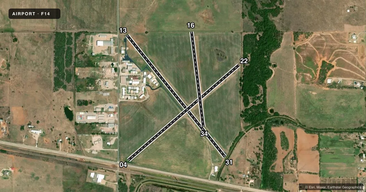
Runways & pattern
Full pagePattern entry · RWY 16
LEFT TRAFFIC| Runway | Heading (°M) | Length | Surface | Traffic |
|---|---|---|---|---|
| 13/31 | 131° / 311° | 3,320 ft | ASPH | Standard L |
| 04/22 | 39° / 219° | 3,107 ft | TURF | Standard L |
| 16/34Favored | 163° / 343° | 2,037 ft | TURF | Standard L |
Runway end performance
| End | TORA | TODA | ASDA | LDA | VGSI | Approach lights | Obstruction |
|---|---|---|---|---|---|---|---|
| 13 | — | — | — | — | — | — | 15', road, 200' from thr, 57' R of cntrln, slope 0 |
| 31 | — | — | — | — | — | — | 20', tree, 375' from thr, 125' R of cntrln, slope 8 |
| 04 | — | — | — | — | — | — | 34', pline, 50' from thr, 0' R of cntrln, slope 1 |
| 22 | — | — | — | — | — | — | 38', trees, 130' from thr, 90' R of cntrln, slope 3 |
| 16 | — | — | — | — | — | — | 4', fence, 80' from thr, 0' R of cntrln, slope 20 |
| 34 | — | — | — | — | — | — | 30', pline, 1000' from thr, 0' R of cntrln, slope 33 |
Declared distances in feet. TORA = takeoff run available, TODA = takeoff distance, ASDA = accelerate-stop, LDA = landing distance.
Airport sketch
Runways drawn to scale from FAA survey coordinates, rendered over satellite imagery. Not for navigation.
Approaches & charts
Services on the field
Fuel grades, oxygen, maintenance, ramp storage and lighting — as declared to the FAA by the airport operator.
Fuel & services
- Fuel
- 100LL
- Other services
- AGRI
Ramp & ground
- Transient storage
- Tie-down
- Hangar
- Landing fee
- No fee published
- Customs
- Not available
- Lighting schedule
- SS-SR
- Wind indicator
- Yes
- Segmented circle
- No
Fuel & FBOs
Cheapest 100LL and Jet A on the field and nearby. Always confirm with the FBO before taxi.
Airport notes
Surface conditions, obstructions, local procedures, lighting outages and other notes published with each FAA cycle.
General notes
- <UNLGTD TOWER 150'AGL 2MI SOUTH.
- INTENSIVE JET TRAINER TFC 2800-4500 FT MSL VICINITY OF ARPT & SHEPPARD AFB 6 MILES NE. CTC APCH CTL FOR TFC ADVISORIES.
- FOR CD CTC FORT WORTH ARTCC AT 817-858-7584.
Fuel notes
- 100LLSELF SVC FUEL.
Runway surface & condition
- 13/31RWY 13/31 NSTD LIRL. RWY 13 THLD LGTS 2 GREEN/RED; RWY 31 THLD LGTS 2 GREEN/RED.
Approach & departure obstructions
- 134 FT FENCE 0-143 FT DSTC, 15 FT RD 126 FT DSTC.
- 316 FT BANK 50 FT DSTC.
- 13MARKINGS NSTD; NRS & CNTRLN SMALL.
- 31MARKINGS NSTD; NRS & CNTRLN SMALL.
Other notes
- THIS AIRPORT HAS BEEN SURVEYED BY THE NATIONAL GEODETIC SURVEY.
- PRE DATES THE ACT.
VFR map & nearby airports
VFR sectional. Tap any ICAO chip to open that airport.
Key facts · F14
Answer card- ICAO
- F14
- Name
- WICHITA VALLEY
- Location
- WICHITA FALLS, TEXAS
- Elevation
- 1,005.1 ft MSL
- Traffic pattern altitude
- 2,005.1 ft MSL (1,000 AGL)
- Control tower
- Non-towered (use CTAF)
- Total runways
- 3
- Longest runway
- 13/31 · 3,320 ft
- Published ILS approaches
- 0
- Published frequencies
- 4
- Magnetic variation
- 10°
- Current flight rules
- VFR
- Current wind
- 180° at 9 kt
- Favored runway now
- RWY 16
Wichita Valley Airport is in Wichita Falls, Texas. The field elevation is 1,005.1 ft MSL. It has three runways. The longest is runway 13/31 at 3,320 ft asphalt. Runways 16/34 and 04/22 are turf. There is no control tower. Pattern altitude is not published, so use the standard 1,000 ft AGL for light piston traffic unless the current Chart Supplement says otherwise.
No ILS approaches are published here. The airport sits near Sheppard Air Force Base. Intensive jet trainer traffic occurs in the area between 2,800 and 4,500 ft MSL. Get traffic advisories from approach control when you can. Runway 13/31 has nonstandard low intensity lighting. The markings are also nonstandard. Runway 31 has a 6 ft bank close off the departure end. Runway 13 has a 4 ft fence and a road near the threshold area. There is also an unlighted tower 2 miles south that rises 150 ft AGL.
Wichita Valley Airport, the on-field FBO, carries self-serve 100LL. Call (940) 781-7246 for current availability. CTAF and UNICOM are both 122.8. For clearance delivery, contact Fort Worth ARTCC at 817-858-7584.