METAR & TAF KFDR
Current METAR
Observed 10:53Z
KFDR 271053Z AUTO 18007KT 10SM CLR 25/18 A2988 RMK AO2 SLP096 T02500178
- Wind
- 180° @ 7 kt
- Visibility
- 10 SM
- Temp / Dew
- 25°C / 18°C
- Altimeter
- 29.88 inHg
- Clouds
- CLR
- Density alt
- 2,810 ft
- Ceiling
- Unlimited
- Rules
- VFR
Airport info & contacts
Manager on record, flight service, ARTCC, attendance schedule and pattern altitude — published by the FAA and refreshed every 28 days.
Location
- From city
- 3 NM SE
- VFR sectional
- DALLAS-FT WORTH
- ARTCC
- ZFW · FORT WORTH
- NOTAM facility
- FDR (NOTAM-D)
Airport manager
- Name
- JIMMY GAITHER
- Phone
- 580-335-2421
- Address
- CITY HALL PO BOX 399, FREDERICK OK 73542
Flight service · Hours
- FSS MLC
- MC ALESTER1-800-WX-BRIEF
- Attendance
- MON-SAT · 0800-1700
- SUN · 1300-1700
Frequencies
Tap any row to copy the frequency to your clipboard.
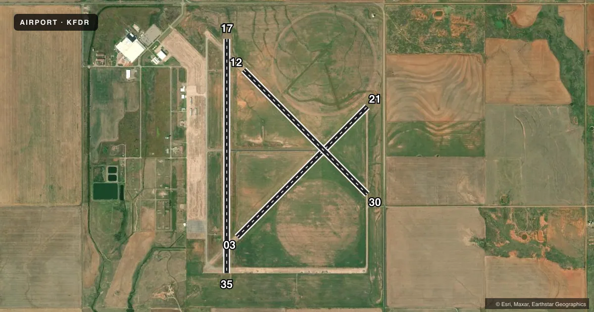
Runways & pattern
Full pagePattern entry · RWY 17
LEFT TRAFFIC| Runway | Heading (°M) | Length | Surface | Traffic |
|---|---|---|---|---|
| 17/35Favored | 173° / 353° | 6,099 ft | ASPH | Standard L |
| 03/21 | 38° / 218° | 4,812 ft | CONC | Standard L |
| 12/30 | 128° / 308° | 4,578 ft | CONC | Standard L |
Runway end performance
| End | TORA | TODA | ASDA | LDA | VGSI | Approach lights | Obstruction |
|---|---|---|---|---|---|---|---|
| 17 | — | — | — | — | PAPI 4-box left(3°) | — | — |
| 35 | — | — | — | — | PAPI 4-box left(3°) | — | — |
| 21 | — | — | — | — | — | — | 15', road, 350' from thr, 250' R of cntrln, slope 10 |
| 30 | — | — | — | — | — | — | 13', road, 350' from thr, 250' R of cntrln, slope 11 |
Declared distances in feet. TORA = takeoff run available, TODA = takeoff distance, ASDA = accelerate-stop, LDA = landing distance.
Airport sketch
Runways drawn to scale from FAA survey coordinates, rendered over satellite imagery. Not for navigation.
Approaches & charts
Services on the field
Fuel grades, oxygen, maintenance, ramp storage and lighting — as declared to the FAA by the airport operator.
Fuel & services
- Fuel
- 100LL
- Oxygen (bottled)
- Not available
- Oxygen (bulk)
- Not available
- Airframe repair
- Not available
- Power plant repair
- Not available
- Other services
- AGRI
Ramp & ground
- Transient storage
- Tie-down
- Landing fee
- No fee published
- Customs
- Not available
- Lighting schedule
- SEE RMK
- Beacon schedule
- SS-SR
- Beacon
- White / Green (civil land)(WG)
- Wind indicator
- Lighted
- Segmented circle
- Yes
Fuel & FBOs
Cheapest 100LL and Jet A on the field and nearby. Always confirm with the FBO before taxi.
Airport notes
Surface conditions, obstructions, local procedures, lighting outages and other notes published with each FAA cycle.
General notes
- ARPT USED AS SHEPPARD AFB AUX. MIL TFC DALGT MON-FRI; CTC UNICOM FOR ADZY.
- MIL TFC ONLY WL USE RIGHT 360 DEG OVERHEAD APCHS TO RY 17.
- FOR CD CTC FORT WORTH ARTCC AT 817-858-7584.
Lighting notes
- ACTVT MIRL RWY 17/35 - CTAF. PAPI RWY 17 & 35 ON CONSLY.
Fuel notes
- 100LLSELF SER FUEL AVBL 24 HRS, FOR ASSISTANCE CALL 580-335-1948.
Runway surface & condition
- 03/21MKD TO 60 FT WIDE; PAVEMENT 150 FT WIDE.
- 12/30RY MKD TO 75 FT WIDE; PAVEMENT 150 FT WIDE.
Other notes
- PRE DATES THE ACT.
- 03/21MODERATE CRACKING AND DETERIORATION.
- 12/30MODERATE CRACKING AND DETERIORATION.
VFR map & nearby airports
VFR sectional. Tap any ICAO chip to open that airport.
Key facts · KFDR
Answer card- ICAO
- KFDR
- Name
- FREDERICK RGNL
- Location
- FREDERICK, OKLAHOMA
- Elevation
- 1,258 ft MSL
- Traffic pattern altitude
- 2,258 ft MSL (1,000 AGL)
- Control tower
- Non-towered (use CTAF)
- Total runways
- 3
- Longest runway
- 17/35 · 6,099 ft
- Published ILS approaches
- 0
- Published frequencies
- 5
- Magnetic variation
- 7°
- Current flight rules
- VFR
- Current wind
- 180° at 7 kt
- Favored runway now
- RWY 17
Frederick Rgnl (KFDR) sits in Frederick, Oklahoma at 1,258 ft MSL. It has three runways. The longest is 17/35 at 6,099 ft. This is a non-towered field. CTAF and UNICOM are both 123.05. Approach and departure services are handled through Altus on the published frequencies.
No ILS approaches are published here. Pattern altitude is not published in the facts, so use the current Chart Supplement before flight. The field is also used as a Sheppard Air Force Base auxiliary. Military traffic is active Monday through Friday. Expect to use UNICOM for advisories and be ready for military operations in the pattern. Right 360 degree overhead approaches to runway 17 are for military traffic only.
The on-field FBO is Frederick Regional Airport. It carries AVGAS 100LL. Self-serve fuel is available 24 hours. If you need help with fuel, the published number is (580) 335-1948. Runway 17/35 has medium intensity lights that are activated by CTAF. PAPI is on continuously for runways 17 and 35. Runways 03/21 and 12/30 are concrete. Both have published cracking and deterioration notes. Runway 12/30 is marked 75 feet wide. Runway 03/21 is marked 60 feet wide. For clearance delivery, contact Fort Worth ARTCC before departure.