METAR & TAF KAXS
Current METAR
Observed 13:08Z
KAXS 271308Z AUTO 16005KT 10SM CLR 26/19 A2993 RMK AO2
- Wind
- 160° @ 5 kt
- Visibility
- 10 SM
- Temp / Dew
- 26°C / 19°C
- Altimeter
- 29.93 inHg
- Clouds
- CLR
- Density alt
- 3,085 ft
- Ceiling
- Unlimited
- Rules
- VFR
Airport info & contacts
Manager on record, flight service, ARTCC, attendance schedule and pattern altitude — published by the FAA and refreshed every 28 days.
Location
- From city
- 3 NM N
- VFR sectional
- DALLAS-FT WORTH
- ARTCC
- ZFW · FORT WORTH
- NOTAM facility
- AXS (NOTAM-D)
Airport manager
- Name
- DANIEL ADAMS
- Phone
- 580-482-8833
- Address
- 509 S. MAIN, ALTUS OK 73521
Flight service · Hours
- FSS MLC
- MC ALESTER1-800-WX-BRIEF
- Attendance
- 0800-1800
Frequencies
Tap any row to copy the frequency to your clipboard.
Runways & pattern
Full pagePattern entry · RWY 17
RIGHT TRAFFICRunway end performance
| End | TORA | TODA | ASDA | LDA | VGSI | Approach lights | Obstruction |
|---|---|---|---|---|---|---|---|
| 17 | — | — | — | — | PAPI 4-box left(3°) | ODALS | — |
| 35 | — | — | — | — | PAPI 4-box left(3°) | — | — |
Declared distances in feet. TORA = takeoff run available, TODA = takeoff distance, ASDA = accelerate-stop, LDA = landing distance.
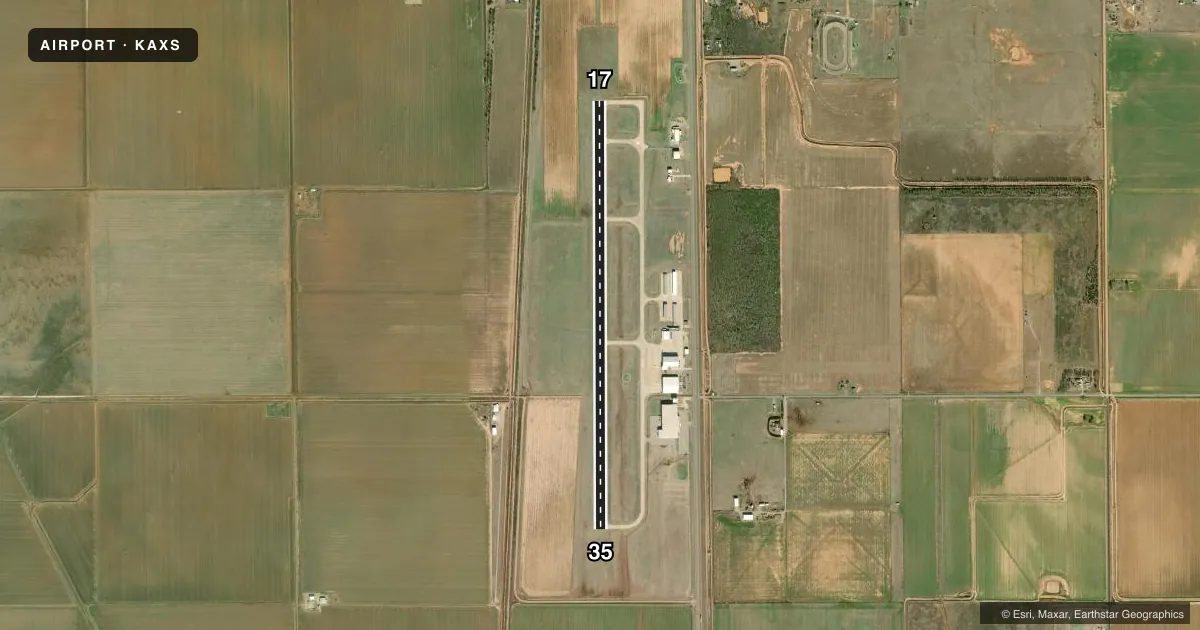
Airport sketch
Runways drawn to scale from FAA survey coordinates, rendered over satellite imagery. Not for navigation.
Approaches & charts
Services on the field
Fuel grades, oxygen, maintenance, ramp storage and lighting — as declared to the FAA by the airport operator.
Fuel & services
- Fuel
- 100LLA+
- Oxygen (bottled)
- Not available
- Oxygen (bulk)
- Not available
- Airframe repair
- Major
- Power plant repair
- Major
- Other services
- AMB,INSTR,RNTL,SALES
Ramp & ground
- Transient storage
- Tie-down
- Hangar
- Landing fee
- No fee published
- Customs
- Not available
- Lighting schedule
- SEE RMK
- Beacon schedule
- SS-SR
- Beacon
- White / Green (civil land)(WG)
- Wind indicator
- Lighted
- Segmented circle
- Yes
Fuel & FBOs
Cheapest 100LL and Jet A on the field and nearby. Always confirm with the FBO before taxi.
Airport notes
Surface conditions, obstructions, local procedures, lighting outages and other notes published with each FAA cycle.
General notes
- DO NOT MISTAKE ARPT FOR ALTUS AFB 4 MI SE.
- MIL JET, AGRICULTURAL & ULTRALIGHT ACT ON & INVOF ARPT.
- 320 FT TWR 2.6 MI S.
- FOR CD CTC FORT WORTH ARTCC AT 817-858-7584.
Lighting notes
- ACTVT ODALS RWY 17; REIL RWY 35; MIRL RWY 17/35 - CTAF. PAPI RWY 17 & 35 ON CONSLY.
Other notes
- THIS AIRPORT HAS BEEN SURVEYED BY THE NATIONAL GEODETIC SURVEY.
- 2SVC AFT HR - 580-471-0992.
VFR map & nearby airports
VFR sectional. Tap any ICAO chip to open that airport.
Key facts · KAXS
Answer card- ICAO
- KAXS
- Name
- ALTUS/QUARTZ MOUNTAIN RGNL
- Location
- ALTUS, OKLAHOMA
- Elevation
- 1,433.2 ft MSL
- Traffic pattern altitude
- 2,433.2 ft MSL (1,000 AGL)
- Control tower
- Non-towered (use CTAF)
- Total runways
- 1
- Longest runway
- 17/35 · 5,501 ft
- Published ILS approaches
- 0
- Published frequencies
- 5
- Magnetic variation
- 5°
- Current flight rules
- VFR
- Current wind
- 160° at 5 kt
- Favored runway now
- RWY 17
Altus/Quartz Mountain Rgnl Airport is in Altus, Oklahoma. The field elevation is 1,433.2 ft MSL. It has one runway, 17/35, which is 5,501 ft long. There is no control tower. Pattern altitude is not published, so light piston pilots should plan on the standard 1,000 ft AGL unless the current Chart Supplement says otherwise.
No ILS approaches are published here. The field has CTAF and UNICOM on 122.8. Published remarks say the approach lighting system is active for runway 17. Runway end identifier lights are on runway 35. Medium intensity runway lights are on both ends and are controlled by CTAF. PAPI is on continuously for runways 17 and 35. The on-field FBO is Altus Quartz Mountain Regional Airport. It carries 100LL and Jet A. Call (580) 482-8833 for current service details.
This airport sits near military jet, agricultural and ultralight traffic. Do not confuse it with Altus Air Force Base, which is 4 miles southeast. There is also a 320-foot tower 2.6 miles south. For IFR clearance delivery, contact Fort Worth ARTCC at 817-858-7584. If you need after-hours service, the published number is 580-471-0992. Check the current FAA Chart Supplement before you go for any changes to lighting, traffic flow, or local procedures.