METAR & TAF O35
O35 does not publish a METAR.
Showing the nearest reporting station: KCDS (CHILDRESS MUNI) · 24.9 NM away. Conditions at O35 may differ.
METAR · KCDS
Observed 11:53Z
KCDS 271153Z AUTO 19007KT 10SM CLR 23/16 A2995 RMK AO2 SLP109 T02330156 10278 20228 53004
- Wind
- 190° @ 7 kt
- Visibility
- 10 SM
- Temp / Dew
- 23°C / 16°C
- Altimeter
- 29.95 inHg
- Clouds
- CLR
- Density alt
- 2,980 ft
- Ceiling
- Unlimited
- Rules
- VFR
Airport info & contacts
Manager on record, flight service, ARTCC, attendance schedule and pattern altitude — published by the FAA and refreshed every 28 days.
Location
- From city
- 2 NM N
- VFR sectional
- DALLAS-FT WORTH
- ARTCC
- ZFW · FORT WORTH
- NOTAM facility
- MLC (NOTAM-D)
Airport manager
- Name
- MARK WHISENANT
- Phone
- 580-688-9245
- Address
- PO BOX 188, HOLLIS OK 73550
Flight service · Hours
- FSS MLC
- MC ALESTER1-800-WX-BRIEF
- Attendance
- IRREG
Frequencies
Tap any row to copy the frequency to your clipboard.
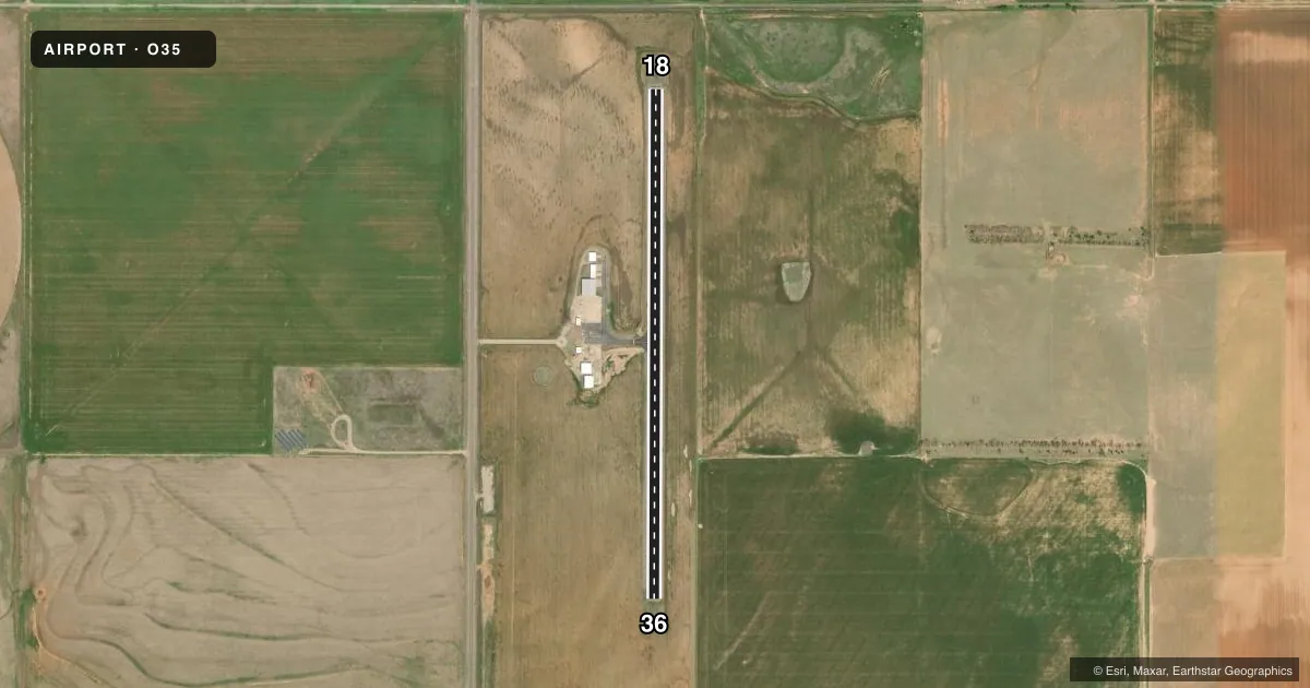
Runways & pattern
Full pagePattern entry · RWY 18
LEFT TRAFFICRunway end performance
| End | TORA | TODA | ASDA | LDA | VGSI | Approach lights | Obstruction |
|---|---|---|---|---|---|---|---|
| 18 | — | — | — | — | — | — | 15', road, 465' from thr, 0' R of cntrln, slope 17 |
Declared distances in feet. TORA = takeoff run available, TODA = takeoff distance, ASDA = accelerate-stop, LDA = landing distance.
Airport sketch
Runways drawn to scale from FAA survey coordinates, rendered over satellite imagery. Not for navigation.
Approaches & charts
Services on the field
Fuel grades, oxygen, maintenance, ramp storage and lighting — as declared to the FAA by the airport operator.
Fuel & services
- Fuel
- 100LL
- Oxygen (bottled)
- Not available
- Oxygen (bulk)
- Not available
- Airframe repair
- Not available
- Power plant repair
- Not available
- Other services
- AGRI
Ramp & ground
- Transient storage
- Tie-down
- Landing fee
- No fee published
- Customs
- Not available
- Lighting schedule
- SEE RMK
- Beacon schedule
- SS-SR
- Beacon
- White / Green (civil land)(WG)
- Wind indicator
- Lighted
- Segmented circle
- Yes
Fuel & FBOs
Cheapest 100LL and Jet A on the field and nearby. Always confirm with the FBO before taxi.
Airport notes
Surface conditions, obstructions, local procedures, lighting outages and other notes published with each FAA cycle.
General notes
- FOR CD CTC FORT WORTH ARTCC AT 817-858-7584.
Lighting notes
- ACTVT MIRL RWY 18/36 - CTAF.
Fuel notes
- 100LLFOR FUEL CALL POLICE 580-688-9216.
Other notes
- MANAGERCITY MANAGER.
VFR map & nearby airports
VFR sectional. Tap any ICAO chip to open that airport.
Key facts · O35
Answer card- ICAO
- O35
- Name
- HOLLIS MUNI
- Location
- HOLLIS, OKLAHOMA
- Elevation
- 1,659.2 ft MSL
- Traffic pattern altitude
- 2,659.2 ft MSL (1,000 AGL)
- Control tower
- Non-towered (use CTAF)
- Total runways
- 1
- Longest runway
- 18/36 · 3,000 ft
- Published ILS approaches
- 0
- Published frequencies
- 3
- Magnetic variation
- 5°
- Current flight rules
- VFR
- Current wind
- 190° at 7 kt
- Favored runway now
- RWY 18
HOLLIS MUNI is in Hollis, Oklahoma. The field elevation is 1,659.2 ft MSL. It has one runway, 18/36, which is 3,000 ft long with an asphalt surface. There is no control tower. No ILS approaches are published here. Pattern altitude is not published, so use the standard 1,000 ft AGL pattern unless the current Chart Supplement says otherwise.
The airport sits in southwest Oklahoma with a single north-south runway. That means runway choice is simple. Winds matter. The published remarks say the medium intensity runway lights on 18/36 are activated by the CTAF. That is useful for night arrivals. For clearance delivery, contact Fort Worth ARTCC at 817-858-7584. There are no on-field FBOs listed. Fuel availability is handled through the local contact in the remarks. Call the police at 580-688-9216 for 100LL fuel information before you go.
For a first-time arrival, the main things to verify are current runway lighting procedures, fuel access and any updated remarks in the current Chart Supplement. This is an uncontrolled field, so standard see-and-avoid and self-announced traffic calls on CTAF matter. If you need IFR planning details, check the current Chart Supplement before departure.