METAR & TAF 2K4
2K4 does not publish a METAR.
Showing the nearest reporting station: KAXS (ALTUS/QUARTZ MOUNTAIN RGNL) · 14.9 NM away. Conditions at 2K4 may differ.
METAR · KAXS
Observed 13:08Z
KAXS 271308Z AUTO 16005KT 10SM CLR 26/19 A2993 RMK AO2
- Wind
- 160° @ 5 kt
- Visibility
- 10 SM
- Temp / Dew
- 26°C / 19°C
- Altimeter
- 29.93 inHg
- Clouds
- CLR
- Density alt
- 3,346 ft
- Ceiling
- Unlimited
- Rules
- VFR
Airport info & contacts
Manager on record, flight service, ARTCC, attendance schedule and pattern altitude — published by the FAA and refreshed every 28 days.
Location
- From city
- 2 NM NW
- VFR sectional
- DALLAS-FT WORTH
- ARTCC
- ZFW · FORT WORTH
- NOTAM facility
- MLC (NOTAM-D)
Airport manager
- Name
- STEVE KYLE
- Phone
- 580-782-2250
- Address
- CITY HALL, 201 N. OKLAHOMA, MANGUM OK 73554
Flight service · Hours
- FSS MLC
- MC ALESTER1-800-WX-BRIEF
- Attendance
- Unattended
Frequencies
Tap any row to copy the frequency to your clipboard.
Runways & pattern
Full pagePattern entry · RWY 17
LEFT TRAFFICRunway end performance
| End | TORA | TODA | ASDA | LDA | VGSI | Approach lights | Obstruction |
|---|---|---|---|---|---|---|---|
| 35 | — | — | — | — | — | — | 23', trees, 474' from thr, 0' R of cntrln, slope 11 |
Declared distances in feet. TORA = takeoff run available, TODA = takeoff distance, ASDA = accelerate-stop, LDA = landing distance.
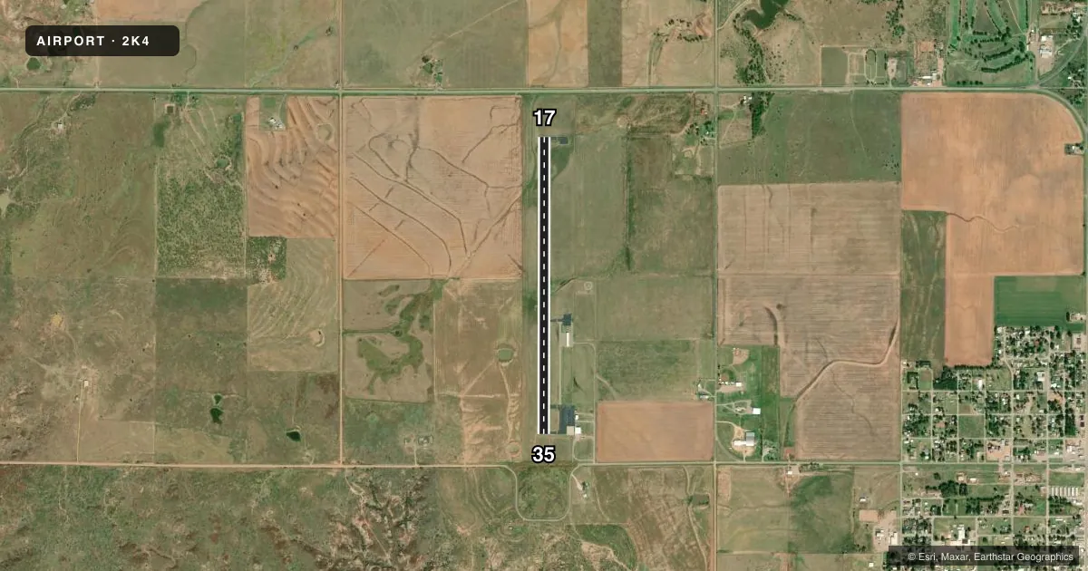
Airport sketch
Runways drawn to scale from FAA survey coordinates, rendered over satellite imagery. Not for navigation.
Approaches & charts
Services on the field
Fuel grades, oxygen, maintenance, ramp storage and lighting — as declared to the FAA by the airport operator.
Fuel & services
- Fuel
- 100LL
- Oxygen (bottled)
- Not available
- Oxygen (bulk)
- Not available
- Airframe repair
- Major
- Power plant repair
- Major
Ramp & ground
- Transient storage
- Tie-down
- Landing fee
- No fee published
- Customs
- Not available
- Lighting schedule
- SS-SR
- Beacon schedule
- SS-SR
- Beacon
- White / Green (civil land)(WG)
- Wind indicator
- Lighted
- Segmented circle
- Yes
Fuel & FBOs
Cheapest 100LL and Jet A on the field and nearby. Always confirm with the FBO before taxi.
Airport notes
Surface conditions, obstructions, local procedures, lighting outages and other notes published with each FAA cycle.
General notes
- PHONE 580-782-3383 FOR RIDE TO TOWN.
- 30 FT PWR LN 500 FT EAST END RWY 35.
- DRAINAGE DITCH ADJ RWY 17 75 FT WEST.
- ULTRALIGHTS ON AND INVOF ARPT.
- FOR CD CTC FORT WORTH ARTCC AT 817-858-7584.
Fuel notes
- 100LL24 HR AUTOMATED CREDIT CARD SYS.
Other notes
- MANAGERELEC DEPT MGR.
VFR map & nearby airports
VFR sectional. Tap any ICAO chip to open that airport.
Key facts · 2K4
Answer card- ICAO
- 2K4
- Name
- SCOTT FLD
- Location
- MANGUM, OKLAHOMA
- Elevation
- 1,643.8 ft MSL
- Traffic pattern altitude
- 2,643.8 ft MSL (1,000 AGL)
- Control tower
- Non-towered (use CTAF)
- Total runways
- 1
- Longest runway
- 17/35 · 4,199 ft
- Published ILS approaches
- 0
- Published frequencies
- 3
- Magnetic variation
- 5°
- Current flight rules
- VFR
- Current wind
- 160° at 5 kt
- Favored runway now
- RWY 17
Scott Field is in Mangum, Oklahoma. The field elevation is 1,643.8 ft MSL. It has one runway. Runway 17/35 is 4,199 ft long with an asphalt surface. There is no control tower. No ILS approaches are published here. The pattern altitude is not published, so use standard 1,000 ft AGL for light piston operations unless the current Chart Supplement says otherwise.
Scott Field has one on-field FBO. Scott Field carries AVGAS 100LL. A 24-hour automated credit card system is available for 100LL fuel. The airport sits in a part of western Oklahoma where wind and density altitude can matter on warm days, so plan your takeoff and landing performance with the field elevation in mind. Published remarks also note a drainage ditch near runway 17, 75 ft west of the runway. There is also a 30 ft power line 500 ft east of the end of runway 35. Ultralights are active on and near the airport, so keep a sharp scan in the pattern and on taxi. For clearance delivery, contact Fort Worth ARTCC at 817-858-7584. If you need a ride to town, the published airport number is 580-782-3383.