METAR & TAF 3O4
3O4 does not publish a METAR.
Showing the nearest reporting station: KELK (ELK CITY RGNL BUSINESS) · 20.4 NM away. Conditions at 3O4 may differ.
METAR · KELK
Observed 13:35Z
KELK 271335Z AUTO 21010KT 10SM CLR 27/17 A2992 RMK AO2 T02750175 $
- Wind
- 210° @ 10 kt
- Visibility
- 10 SM
- Temp / Dew
- 27°C / 17°C
- Altimeter
- 29.92 inHg
- Clouds
- CLR
- Density alt
- 3,842 ft
- Ceiling
- Unlimited
- Rules
- VFR
Airport info & contacts
Manager on record, flight service, ARTCC, attendance schedule and pattern altitude — published by the FAA and refreshed every 28 days.
Location
- From city
- 7 NM S
- VFR sectional
- DALLAS-FT WORTH
- ARTCC
- ZFW · FORT WORTH
- NOTAM facility
- MLC (NOTAM-D)
Airport manager
- Name
- MIKE REED
- Phone
- 580-878-0028
- Address
- 102 W. MAIN, 12714 N. 1860 RD., SAYRE OK 73662
Flight service · Hours
- FSS MLC
- MC ALESTER1-800-WX-BRIEF
- Attendance
- Unattended
Frequencies
Tap any row to copy the frequency to your clipboard.
Runways & pattern
Full pagePattern entry · RWY 17
LEFT TRAFFICRunway end performance
| End | TORA | TODA | ASDA | LDA | VGSI | Approach lights | Obstruction |
|---|---|---|---|---|---|---|---|
| 17 | — | — | — | — | PAPI 2-box left(3°) | — | — |
| 35 | — | — | — | — | PAPI 2-box left(3°) | — | — |
Declared distances in feet. TORA = takeoff run available, TODA = takeoff distance, ASDA = accelerate-stop, LDA = landing distance.
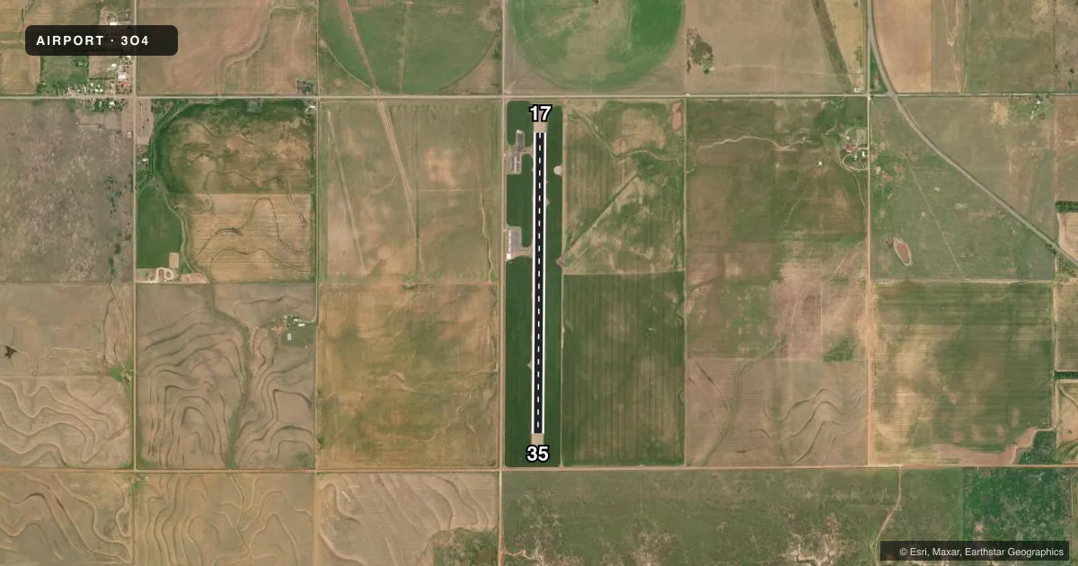
Airport sketch
Runways drawn to scale from FAA survey coordinates, rendered over satellite imagery. Not for navigation.
Approaches & charts
Services on the field
Fuel grades, oxygen, maintenance, ramp storage and lighting — as declared to the FAA by the airport operator.
Fuel & services
- Fuel
- 100LL
- Oxygen (bottled)
- Not available
- Oxygen (bulk)
- Not available
- Airframe repair
- Not available
- Power plant repair
- Not available
- Other services
- AGRI
Ramp & ground
- Transient storage
- Tie-down
- Landing fee
- No fee published
- Customs
- Not available
- Lighting schedule
- SEE RMK
- Beacon schedule
- SS-SR
- Beacon
- White / Green (civil land)(WG)
- Wind indicator
- Lighted
- Segmented circle
- No
Fuel & FBOs
Cheapest 100LL and Jet A on the field and nearby. Always confirm with the FBO before taxi.
Airport notes
Surface conditions, obstructions, local procedures, lighting outages and other notes published with each FAA cycle.
General notes
- FOR CD CTC FORT WORTH ARTCC AT 817-858-7584.
Lighting notes
- ACTVT MIRL RWY 17/35 - CTAF.
Fuel notes
- 100LLSELF SVC FUEL AVBL 24 HRS WITH CREDIT CARD.
Other notes
- PRE DATES THE ACT.
- MANAGERCITY MANAGER.
VFR map & nearby airports
VFR sectional. Tap any ICAO chip to open that airport.
Key facts · 3O4
Answer card- ICAO
- 3O4
- Name
- SAYRE MUNI
- Location
- SAYRE, OKLAHOMA
- Elevation
- 1,937.2 ft MSL
- Traffic pattern altitude
- 2,937.2 ft MSL (1,000 AGL)
- Control tower
- Non-towered (use CTAF)
- Total runways
- 1
- Longest runway
- 17/35 · 4,276 ft
- Published ILS approaches
- 0
- Published frequencies
- 1
- Magnetic variation
- 8°
- Current flight rules
- VFR
- Current wind
- 210° at 10 kt
- Favored runway now
- RWY 17
Sayre Muni sits in Sayre, Oklahoma. Field elevation is 1,937.2 ft MSL. The airport has one runway. Runway 17/35 is 4,276 ft long with a concrete surface. There is no control tower. CTAF is 122.9.
No ILS approaches are published here. Pattern altitude is not published, so use the standard 1,000 ft AGL for light piston traffic unless the current Chart Supplement says otherwise. The runway lights on 17/35 are medium intensity. They are activated by CTAF. Self-service 100LL is available 24 hours with a credit card. There is no on-field FBO listed.
For a first-time arrival, the main things to plan for are the non-towered environment, the field elevation and the lack of published ILS guidance. Clearance delivery is handled through Fort Worth ARTCC at 817-858-7584. Check the current Chart Supplement before you go for any updated airport remarks or local procedures. If you are arriving after dark, confirm lighting activation and be ready to self-announce on CTAF.