METAR & TAF 2F1
2F1 does not publish a METAR.
Showing the nearest reporting station: KELK (ELK CITY RGNL BUSINESS) · 40.5 NM away. Conditions at 2F1 may differ.
METAR · KELK
Observed 17:15Z
KELK 271715Z AUTO 20011KT 10SM CLR 36/16 A2992 RMK AO2 T03630159 $
- Wind
- 200° @ 11 kt
- Visibility
- 10 SM
- Temp / Dew
- 36°C / 16°C
- Altimeter
- 29.92 inHg
- Clouds
- CLR
- Density alt
- 5,458 ft
- Ceiling
- Unlimited
- Rules
- VFR
Airport info & contacts
Manager on record, flight service, ARTCC, attendance schedule and pattern altitude — published by the FAA and refreshed every 28 days.
Location
- From city
- 3 NM NE
- VFR sectional
- DALLAS-FT WORTH
- ARTCC
- ZAB · ALBUQUERQUE
- NOTAM facility
- FTW (NOTAM-D)
Airport manager
- Name
- TROY POTTS
- Phone
- 806-256-3281
- Address
- 116 W. 2ND ST, SHAMROCK TX 79079
Flight service · Hours
- FSS FTW
- FORT WORTH1-800-WX-BRIEF
- Attendance
- Unattended
Frequencies
Tap any row to copy the frequency to your clipboard.
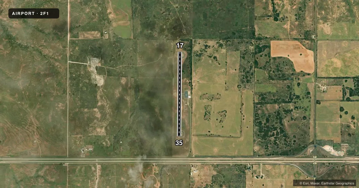
Runways & pattern
Full pagePattern entry · RWY 17
LEFT TRAFFICRunway end performance
| End | TORA | TODA | ASDA | LDA | VGSI | Approach lights | Obstruction |
|---|---|---|---|---|---|---|---|
| 17 | — | — | — | — | — | — | 8', berm, 201' from thr, 107' R of cntrln, slope 0 |
| 35 | — | — | — | — | — | — | 42', trees, 1251' from thr, 0' R of cntrln, slope 25 |
Declared distances in feet. TORA = takeoff run available, TODA = takeoff distance, ASDA = accelerate-stop, LDA = landing distance.
Airport sketch
Runways drawn to scale from FAA survey coordinates, rendered over satellite imagery. Not for navigation.
Approaches & charts
Services on the field
Fuel grades, oxygen, maintenance, ramp storage and lighting — as declared to the FAA by the airport operator.
Fuel & services
- Fuel
- 100LL
- Oxygen (bottled)
- Not available
- Oxygen (bulk)
- Not available
- Airframe repair
- Not available
- Power plant repair
- Not available
- Other services
- AGRI
Ramp & ground
- Transient storage
- Tie-down
- Hangar
- Landing fee
- No fee published
- Customs
- Not available
- Lighting schedule
- SEE RMK
- Beacon schedule
- SS-SR
- Beacon
- White / Green (civil land)(WG)
- Wind indicator
- Lighted
- Segmented circle
- Yes
Fuel & FBOs
Cheapest 100LL and Jet A on the field and nearby. Always confirm with the FBO before taxi.
Airport notes
Surface conditions, obstructions, local procedures, lighting outages and other notes published with each FAA cycle.
General notes
- FOR CD CTC ALBUQUERQUE ARTCC AT 505-856-4861.
- NO TWY MRKGS OR HOLD LINES.
- NMRS RWY LTS OUT.
Lighting notes
- MIRL RWY 17/35 DUSK-0000. AFT 0000 ACTVT - CTAF.
Fuel notes
- 100LLFUEL SELF SVC.
Runway surface & condition
- 17/35LOOSE AGGREGATE ON RWY.
Approach & departure obstructions
- 173-8 FT BERM 97-200 FT FM THR; 107 FT LEFT.
- 17RWY MRKGS FADED, BARELY VSB.
- 35RWY MRKGS FADED, BARELY VSB.
Other notes
- MANAGERCITY MANAGER
- 17/35SEVERE CRACKING.
VFR map & nearby airports
VFR sectional. Tap any ICAO chip to open that airport.
Key facts · 2F1
Answer card- ICAO
- 2F1
- Name
- SHAMROCK MUNI
- Location
- SHAMROCK, TEXAS
- Elevation
- 2,369 ft MSL
- Traffic pattern altitude
- 3,369 ft MSL (1,000 AGL)
- Control tower
- Non-towered (use CTAF)
- Total runways
- 1
- Longest runway
- 17/35 · 3,600 ft
- Published ILS approaches
- 0
- Published frequencies
- 2
- Magnetic variation
- 8°
- Current flight rules
- VFR
- Current wind
- 200° at 11 kt
- Favored runway now
- RWY 17
Shamrock Muni is in Shamrock, Texas. The field elevation is 2,369 ft MSL. It has one runway. Runway 17/35 is 3,600 ft long with asphalt pavement. The airport is non-towered. CTAF and UNICOM are both 122.8. No ILS approaches are published here.
Pattern altitude is not published. Use the standard 1,000 ft AGL pattern unless the current Chart Supplement or local traffic calls for something different. The on-field FBO is Shamrock Municipal Airport. It carries self-serve 100LL. The airport remarks matter here. Runway markings are faded on both ends. The runway has severe cracking. Loose aggregate is reported on the surface. There is also a berm near the Runway 17 threshold, so plan your rollout and departure with that in mind.
Lighting is limited. Medium intensity runway lights on 17/35 operate from dusk to 0000. After 0000, activation is by CTAF. There are no taxiway markings or hold lines. That makes a careful taxi brief a good idea before you move. For clearance delivery, contact Albuquerque ARTCC at 505-856-4861. The airport manager is the city manager. With a 2,369 ft elevation and a single 3,600 ft runway, density altitude and runway condition deserve attention, especially on warm Texas days.