METAR & TAF O13
O13 does not publish a METAR.
Showing the nearest reporting station: KELK (ELK CITY RGNL BUSINESS) · 27.6 NM away. Conditions at O13 may differ.
METAR · KELK
Observed 15:55Z
KELK 271555Z AUTO 22008G16KT 10SM CLR 33/16 A2993 RMK AO2 T03310164 $
- Wind
- 220° @ 8G16 kt
- Visibility
- 10 SM
- Temp / Dew
- 33°C / 16°C
- Altimeter
- 29.93 inHg
- Clouds
- CLR
- Density alt
- 4,748 ft
- Ceiling
- Unlimited
- Rules
- VFR
Airport info & contacts
Manager on record, flight service, ARTCC, attendance schedule and pattern altitude — published by the FAA and refreshed every 28 days.
Location
- From city
- 1 NM SW
- VFR sectional
- DALLAS-FT WORTH
- ARTCC
- ZFW · FORT WORTH
- NOTAM facility
- MLC (NOTAM-D)
Airport manager
- Name
- TODD SUTTON
- Phone
- (580) 243-9190
- Address
- 17212 E 1250 RD, P. O. BOX 25, ERICK OK 73645
Flight service · Hours
- FSS MLC
- MC ALESTER1-800-WX-BRIEF
- Attendance
- Unattended
Frequencies
Tap any row to copy the frequency to your clipboard.
Runways & pattern
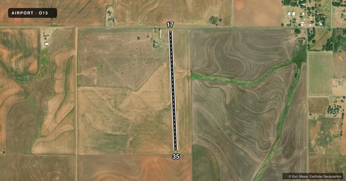
Full pagePattern entry · RWY 17
LEFT TRAFFICAirport sketch
Runways drawn to scale from FAA survey coordinates, rendered over satellite imagery. Not for navigation.
Approaches & charts
Services on the field
Fuel grades, oxygen, maintenance, ramp storage and lighting — as declared to the FAA by the airport operator.
Fuel & services
- Fuel
- Not available
- Oxygen (bottled)
- Not available
- Oxygen (bulk)
- Not available
- Airframe repair
- Not available
- Power plant repair
- Not available
Ramp & ground
- Transient storage
- Not published
- Landing fee
- No fee published
- Wind indicator
- Yes
- Segmented circle
- No
Fuel & FBOs
Cheapest 100LL and Jet A on the field and nearby. Always confirm with the FBO before taxi.
Airport notes
Surface conditions, obstructions, local procedures, lighting outages and other notes published with each FAA cycle.
General notes
- MILITARY HELICOPTER TRAFFIC ON & INVOF ARPT.
- FOR CD CTC FORT WORTH ARTCC AT 817-858-7584.
Lighting notes
- OTS INDEFLY.
Approach & departure obstructions
- 174 FT FENCE AT 65 FT; 15 FT ROAD AT 70 FT; 4 FT TERRAIN RISE AT 106 FT, 8 FT FENCE AT 120 FT.
- 355 FT BRUSH AND HILL 168 FT FROM RUNWAY END.
Other notes
- PRE-DATES THE ACT.
- MANAGERAIRPORT BOARD CHAIRMAN.
- 17/35SVR CRACKING & GRASS ENCROACHMENT.
VFR map & nearby airports
VFR sectional. Tap any ICAO chip to open that airport.
Key facts · O13
Answer card- ICAO
- O13
- Name
- HADDOCK FLD
- Location
- ERICK, OKLAHOMA
- Elevation
- 2,097 ft MSL
- Traffic pattern altitude
- 3,097 ft MSL (1,000 AGL)
- Control tower
- Non-towered (use CTAF)
- Total runways
- 1
- Longest runway
- 17/35 · 2,650 ft
- Published ILS approaches
- 0
- Published frequencies
- 1
- Magnetic variation
- 8°
- Current flight rules
- VFR
- Current wind
- 220° at 8 kt
- Favored runway now
- RWY 17
Haddock Fld sits near Erick, Oklahoma. The field elevation is 2,097 ft MSL. It has one runway. Runway 17/35 is 2,650 ft asphalt with magnetic headings 177° and 357°. There is no control tower. CTAF is 122.9.
No ILS approaches are published here. Pattern altitude is not published, so use the standard 1,000 ft AGL unless the current Chart Supplement says otherwise. That puts the traffic pattern at 3,097 ft MSL based on the field elevation. Verify before you fly. The published remarks matter here. The beacon is out of service indefinitely. Military helicopter traffic is reported on and near the airport. Runway 17/35 also has severe cracking and grass encroachment. There are obstructions near both ends. Those include a fence, road, terrain rise, brush and a hill close to runway 35.
No on-field FBOs are listed. Contact the airport operator directly or call the field on CTAF for current fuel and service availability. For clearance delivery, contact Fort Worth ARTCC at 817-858-7584. A first-time pilot should plan for a small, non-towered field with a short asphalt runway, high elevation and published surface issues. Check the current Chart Supplement before departure for any updated operating notes.