METAR & TAF T59
T59 does not publish a METAR.
Showing the nearest reporting station: KHHF (HEMPHILL COUNTY) · 28.5 NM away. Conditions at T59 may differ.
METAR · KHHF
Observed 17:15Z
KHHF 271715Z AUTO VRB05KT 10SM CLR 40/11 A2991 RMK AO2
- Wind
- VAR @ 5 kt
- Visibility
- 10 SM
- Temp / Dew
- 40°C / 11°C
- Altimeter
- 29.91 inHg
- Clouds
- CLR
- Density alt
- 6,075 ft
- Ceiling
- Unlimited
- Rules
- VFR
Airport info & contacts
Manager on record, flight service, ARTCC, attendance schedule and pattern altitude — published by the FAA and refreshed every 28 days.
Location
- From city
- 4 NM E
- VFR sectional
- DALLAS-FT WORTH
- ARTCC
- ZAB · ALBUQUERQUE
- NOTAM facility
- FTW (NOTAM-D)
Airport manager
- Name
- PAUL ARGNBRIGHT
- Phone
- 806-669-4182
- Address
- 505 ALAN BEAN BLVD, PO BOX 98, WHEELER TX 79096
Flight service · Hours
- FSS FTW
- FORT WORTH1-800-WX-BRIEF
- Attendance
- Unattended
Frequencies
Tap any row to copy the frequency to your clipboard.
Runways & pattern
Full pagePattern entry · RWY 35
LEFT TRAFFICRunway end performance
| End | TORA | TODA | ASDA | LDA | VGSI | Approach lights | Obstruction |
|---|---|---|---|---|---|---|---|
| 35 | — | — | — | — | — | — | 20', road, 564' from thr, 0' R of cntrln, slope 18 |
Declared distances in feet. TORA = takeoff run available, TODA = takeoff distance, ASDA = accelerate-stop, LDA = landing distance.
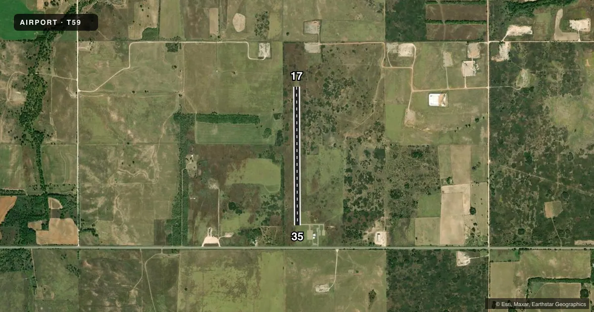
Airport sketch
Runways drawn to scale from FAA survey coordinates, rendered over satellite imagery. Not for navigation.
Approaches & charts
Services on the field
Fuel grades, oxygen, maintenance, ramp storage and lighting — as declared to the FAA by the airport operator.
Fuel & services
- Fuel
- Not available
Ramp & ground
- Transient storage
- Tie-down
- Landing fee
- No fee published
- Lighting schedule
- SS-SR
- Beacon schedule
- SS-SR
- Beacon
- White / Green (civil land)(WG)
- Wind indicator
- Lighted
- Segmented circle
- Yes
Fuel & FBOs
Cheapest 100LL and Jet A on the field and nearby. Always confirm with the FBO before taxi.
Airport notes
Surface conditions, obstructions, local procedures, lighting outages and other notes published with each FAA cycle.
General notes
- 10 FT RISING TRRN 100 FT BOTH SIDES OF CNTRLN.
- FOR CD CTC ALBUQUERQUE ARTCC AT 505-856-4861.
- RWY PAVEMENT CRACKING WITH VEGETATION GROWING THROUGH.
- LIRL RWY 17/35 NMRS LTS OTS.
Approach & departure obstructions
- 35APCH SLOPE 31:1 TO DSPLCD THLD.
Other notes
- THIS AIRPORT HAS BEEN SURVEYED BY THE NATIONAL GEODETIC SURVEY.
- MANAGERPUBLIC WORKS DIRECTOR
VFR map & nearby airports
VFR sectional. Tap any ICAO chip to open that airport.
Key facts · T59
Answer card- ICAO
- T59
- Name
- WHEELER MUNI
- Location
- WHEELER, TEXAS
- Elevation
- 2,469.9 ft MSL
- Traffic pattern altitude
- 3,469.9 ft MSL (1,000 AGL)
- Control tower
- Non-towered (use CTAF)
- Total runways
- 1
- Longest runway
- 17/35 · 3,565 ft
- Published ILS approaches
- 0
- Published frequencies
- 1
- Magnetic variation
- 5°
- Current flight rules
- VFR
- Current wind
- 000° at 5 kt
- Favored runway now
- RWY 35
Wheeler Muni sits in Wheeler, Texas. The field elevation is 2,469.9 ft MSL. It has one runway, 17/35, which is 3,565 ft long on asphalt. There is no control tower. CTAF is 122.9. No ILS approaches are published.
Pattern altitude is not published. Use the standard 1,000 ft AGL pattern for light piston aircraft unless the current Chart Supplement says otherwise. The runway pavement has cracking with vegetation growing through. Low intensity runway lights for runway 17/35 are out of service. That matters if you are planning a night arrival.
The published remarks also note 10 ft of rising terrain 100 ft on both sides of the runway centerline. That is worth keeping in mind on takeoff and landing. The approach slope to the displaced threshold of runway 35 is 31 to 1. The airport manager is the Public Works Director. For clearance delivery, contact Albuquerque ARTCC at 505-856-4861. There are no on-field FBOs listed, so verify services with the airport operator before you go.