METAR & TAF 2E7
2E7 does not publish a METAR.
Showing the nearest reporting station: KPPA (PERRY LEFORS FLD) · 31.1 NM away. Conditions at 2E7 may differ.
METAR · KPPA
Observed 21:50Z
KPPA 262150Z AUTO 14014G19KT 10SM CLR 41/15 A2999 RMK AO2 T04060148
- Wind
- 140° @ 14G19 kt
- Visibility
- 10 SM
- Temp / Dew
- 41°C / 15°C
- Altimeter
- 29.99 inHg
- Clouds
- CLR
- Density alt
- 6,549 ft
- Ceiling
- Unlimited
- Rules
- VFR
Airport info & contacts
Manager on record, flight service, ARTCC, attendance schedule and pattern altitude — published by the FAA and refreshed every 28 days.
Location
- From city
- 3 NM E
- VFR sectional
- DALLAS-FT WORTH
- ARTCC
- ZAB · ALBUQUERQUE
- NOTAM facility
- FTW (NOTAM-D)
Airport manager
- Name
- JEFF HALEY
- Phone
- 806-662-7331
- Address
- PO BOX 42, MCLEAN TX 79057
Flight service · Hours
- FSS FTW
- FORT WORTH1-800-WX-BRIEF
- Attendance
- Unattended
Frequencies
Tap any row to copy the frequency to your clipboard.
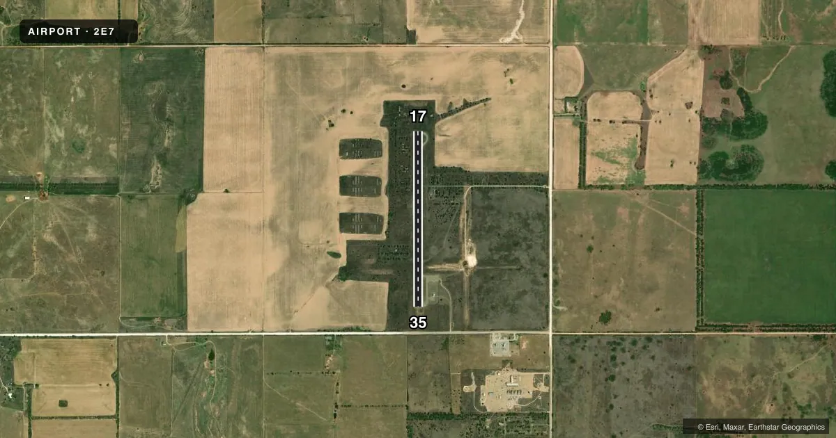
Runways & pattern
Full pagePattern entry · RWY 17
LEFT TRAFFICRunway end performance
| End | TORA | TODA | ASDA | LDA | VGSI | Approach lights | Obstruction |
|---|---|---|---|---|---|---|---|
| 17 | — | — | — | — | — | — | 13', tree, 382' from thr, 66' R of cntrln, slope 14 |
| 35 | — | — | — | — | — | — | 10', road, 464' from thr, 0' R of cntrln, slope 26 |
Declared distances in feet. TORA = takeoff run available, TODA = takeoff distance, ASDA = accelerate-stop, LDA = landing distance.
Airport sketch
Runways drawn to scale from FAA survey coordinates, rendered over satellite imagery. Not for navigation.
Approaches & charts
Services on the field
Fuel grades, oxygen, maintenance, ramp storage and lighting — as declared to the FAA by the airport operator.
Fuel & services
- Fuel
- Not available
- Oxygen (bottled)
- Not available
- Oxygen (bulk)
- Not available
- Airframe repair
- Not available
- Power plant repair
- Not available
Ramp & ground
- Transient storage
- Tie-down
- Landing fee
- No fee published
- Customs
- Not available
- Lighting schedule
- SS-SR
- Beacon schedule
- SS-SR
- Beacon
- White / Green (civil land)(WG)
- Wind indicator
- Lighted
- Segmented circle
- Yes
Fuel & FBOs
Cheapest 100LL and Jet A on the field and nearby. Always confirm with the FBO before taxi.
Airport notes
Surface conditions, obstructions, local procedures, lighting outages and other notes published with each FAA cycle.
General notes
- WILDLIFE ON AND INVOF ARPT.
- NO LINE OF SIGHT BTN RWY ENDS.
- FOR CD CTC ALBUQUERQUE ARTCC AT 505-856-4861.
Lighting notes
- ROTG BCN OTS INDEFLY.
Runway surface & condition
- 17/35NONSTD FRUIT JAR LGTS ON NON-FRANGIBLE METAL CONDUIT. NONSTD COLORS.
Approach & departure obstructions
- 353 FT BERM 0-199 FT DSTC, 112 FT RIGHT.
Other notes
- MANAGERCO.COMMISSIONER/AMGR.
VFR map & nearby airports
VFR sectional. Tap any ICAO chip to open that airport.
Key facts · 2E7
Answer card- ICAO
- 2E7
- Name
- MC LEAN/GRAY COUNTY
- Location
- MC LEAN, TEXAS
- Elevation
- 2,835 ft MSL
- Traffic pattern altitude
- 3,835 ft MSL (1,000 AGL)
- Control tower
- Non-towered (use CTAF)
- Total runways
- 1
- Longest runway
- 17/35 · 3,225 ft
- Published ILS approaches
- 0
- Published frequencies
- 1
- Magnetic variation
- 8°
- Current flight rules
- VFR
- Current wind
- 140° at 14 kt
- Favored runway now
- RWY 17
MC LEAN/GRAY COUNTY (2E7) sits at Mc Lean, Texas. Field elevation is 2,835 ft MSL. The airport has one runway. Runway 17/35 is 3,225 ft long with an asphalt surface. There is no control tower. CTAF is 122.9. No ILS approaches are published.
Pattern altitude is not published. Use 1,000 ft AGL for light piston operations unless the current Chart Supplement says otherwise. The field sits in open country with a high elevation for a small airport. That means density altitude can matter on warm days. Wildlife is reported on and near the airport. The runway ends do not have line of sight to each other. That is worth keeping in mind for traffic calls and runway checks.
Published remarks also note nonstandard runway lighting on 17/35. The rotating beacon is out of service indefinitely. There is a 3-foot berm near the runway 35 end, 112 feet right of centerline, from 0 to 199 feet out. For clearance delivery, contact Albuquerque ARTCC at 505-856-4861. No on-field FBOs are listed, so contact the airport operator directly before arrival or call on CTAF for current fuel and service status.