METAR & TAF E34
E34 does not publish a METAR.
Showing the nearest reporting station: KCDS (CHILDRESS MUNI) · 40.6 NM away. Conditions at E34 may differ.
METAR · KCDS
Observed 15:53Z
KCDS 271553Z AUTO 19011KT 10SM CLR 33/17 A2995 RMK AO2 SLP110 T03280172
- Wind
- 190° @ 11 kt
- Visibility
- 10 SM
- Temp / Dew
- 33°C / 17°C
- Altimeter
- 29.95 inHg
- Clouds
- CLR
- Density alt
- 5,636 ft
- Ceiling
- Unlimited
- Rules
- VFR
Airport info & contacts
Manager on record, flight service, ARTCC, attendance schedule and pattern altitude — published by the FAA and refreshed every 28 days.
Location
- From city
- 2 NM SE
- VFR sectional
- DALLAS-FT WORTH
- ARTCC
- ZAB · ALBUQUERQUE
- NOTAM facility
- FTW (NOTAM-D)
Airport manager
- Name
- BRIAN BARBOZA
- Phone
- 806-874-3438
- Address
- 313 S SULLY ST, PO BOX 1089, CLARENDON TX 79226
Flight service · Hours
- FSS FTW
- FORT WORTH1-800-WX-BRIEF
- Attendance
- Unattended
Frequencies
Tap any row to copy the frequency to your clipboard.
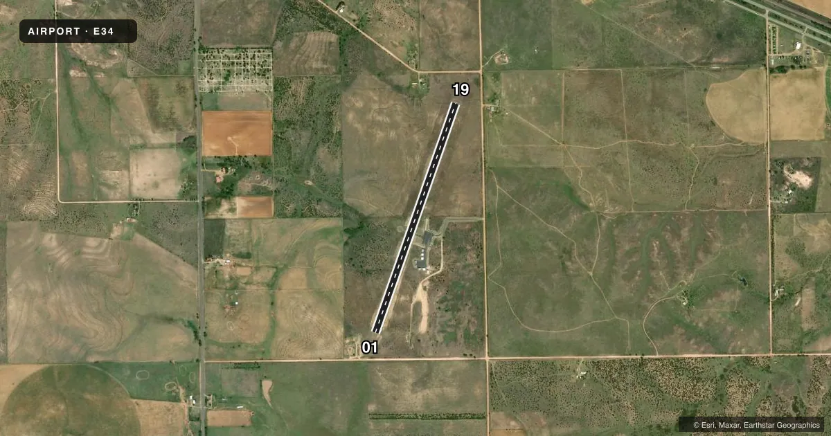
Runways & pattern
Full pagePattern entry · RWY 19
LEFT TRAFFICRunway end performance
| End | TORA | TODA | ASDA | LDA | VGSI | Approach lights | Obstruction |
|---|---|---|---|---|---|---|---|
| 01 | — | — | — | — | — | — | 5', berm, 201' from thr, 143' R of cntrln, slope 0 |
Declared distances in feet. TORA = takeoff run available, TODA = takeoff distance, ASDA = accelerate-stop, LDA = landing distance.
Airport sketch
Runways drawn to scale from FAA survey coordinates, rendered over satellite imagery. Not for navigation.
Approaches & charts
Services on the field
Fuel grades, oxygen, maintenance, ramp storage and lighting — as declared to the FAA by the airport operator.
Fuel & services
- Fuel
- Not available
Ramp & ground
- Transient storage
- Tie-down
- Landing fee
- No fee published
- Customs
- Not available
- Lighting schedule
- SEE RMK
- Beacon schedule
- SEE RMK
- Beacon
- White / Green (civil land)(WG)
- Wind indicator
- Lighted
- Segmented circle
- Yes
Fuel & FBOs
Cheapest 100LL and Jet A on the field and nearby. Always confirm with the FBO before taxi.
Airport notes
Surface conditions, obstructions, local procedures, lighting outages and other notes published with each FAA cycle.
General notes
- NO LINE OF SIGHT BTN RWY ENDS.
- FOR CD CTC ALBUQUERQUE ARTCC AT 505-856-4861.
Lighting notes
- ACTVT ROTG BCN - 122.8.
- DUSK-DAWN. MIRL RWY 01/19 PRESET LOW INTST; TO INCR INTST ACTVT - 122.8.
Approach & departure obstructions
- 015 FT BERM 0-199 FT DSTC, 143 R.
- 01APPROACH SLOPE 20:1 BASED ON STRAIGHT OUT.
Other notes
- THIS AIRPORT HAS BEEN SURVEYED BY THE NATIONAL GEODETIC SURVEY.
- MANAGERCITY ADMIN
- MANAGEROFFICE; 806-440-1805 CELL B.BARBOZA@CITYOFCLARENDONTX.COM
VFR map & nearby airports
VFR sectional. Tap any ICAO chip to open that airport.
Key facts · E34
Answer card- ICAO
- E34
- Name
- SMILEY JOHNSON MUNI/BASS FLD
- Location
- CLARENDON, TEXAS
- Elevation
- 2,832.9 ft MSL
- Traffic pattern altitude
- 3,832.9 ft MSL (1,000 AGL)
- Control tower
- Non-towered (use CTAF)
- Total runways
- 1
- Longest runway
- 01/19 · 4,496 ft
- Published ILS approaches
- 0
- Published frequencies
- 1
- Magnetic variation
- 8°
- Current flight rules
- VFR
- Current wind
- 190° at 11 kt
- Favored runway now
- RWY 19
Smiley Johnson Muni/Bass Fld sits in Clarendon, Texas. Field elevation is 2,832.9 ft MSL. The airport has one runway. Runway 01/19 is 4,496 ft of asphalt, which is the longest runway on the field. There is no control tower. CTAF is 122.9.
No ILS approaches are published here. Pattern altitude is not published in the facts, so use the standard 1,000 ft AGL for light piston operations unless the current FAA Chart Supplement says otherwise. The published remarks also note a rotating beacon on 122.8. Runway 01/19 has medium intensity lights that come up in low intensity from dusk to dawn. Use 122.8 to increase intensity. There is also a 5-foot berm near the runway 01 end, off to the right side. The straight-out approach to runway 01 has a 20 to 1 slope note. The field has no line of sight between runway ends, so plan your traffic and taxi calls with that in mind.
No on-field FBOs are listed. Contact the airport operator directly before arrival if you need services. The airport manager is the city administration. For clearance delivery, contact Albuquerque ARTCC at 505-856-4861. This is a high-elevation airport, so expect performance to matter on warm days. Check density altitude before you go.