METAR & TAF F21
F21 does not publish a METAR.
Showing the nearest reporting station: KCDS (CHILDRESS MUNI) · 21.9 NM away. Conditions at F21 may differ.
METAR · KCDS
Observed 12:53Z
KCDS 271253Z AUTO 20006KT 10SM CLR 26/16 A2995 RMK AO2 SLP108 T02610161
- Wind
- 200° @ 6 kt
- Visibility
- 10 SM
- Temp / Dew
- 26°C / 16°C
- Altimeter
- 29.95 inHg
- Clouds
- CLR
- Density alt
- 3,889 ft
- Ceiling
- Unlimited
- Rules
- VFR
Airport info & contacts
Manager on record, flight service, ARTCC, attendance schedule and pattern altitude — published by the FAA and refreshed every 28 days.
Location
- From city
- 1 NM NE
- VFR sectional
- DALLAS-FT WORTH
- ARTCC
- ZAB · ALBUQUERQUE
- NOTAM facility
- FTW (NOTAM-D)
Airport manager
- Name
- DAVID MORRIS
- Phone
- 806-259-3001
- Address
- 721 ROBERTSON ST, MEMPHIS TX 79245
Flight service · Hours
- FSS FTW
- FORT WORTH1-800-WX-BRIEF
- Attendance
- Unattended
Frequencies
Tap any row to copy the frequency to your clipboard.
Runways & pattern
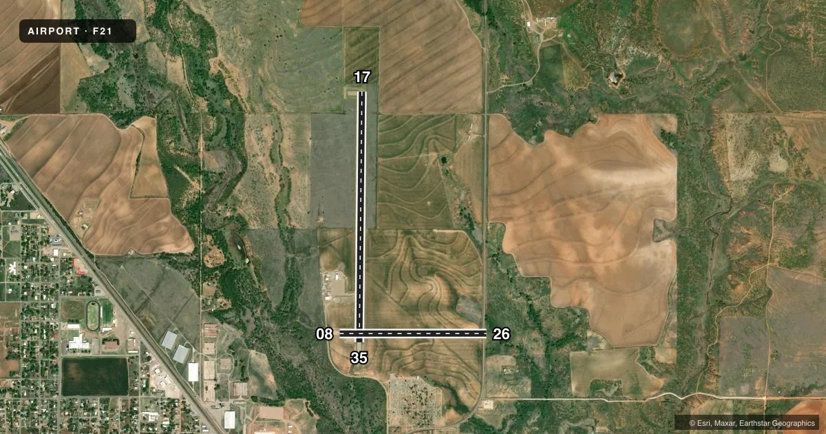
Full pagePattern entry · RWY 17
LEFT TRAFFIC| Runway | Heading (°M) | Length | Surface | Traffic |
|---|---|---|---|---|
| 17/35Favored | 173° / 353° | 4,670 ft | ASPH | Standard L |
| 08/26 | 82° / 262° | 2,750 ft | TURF | Standard L |
Runway end performance
| End | TORA | TODA | ASDA | LDA | VGSI | Approach lights | Obstruction |
|---|---|---|---|---|---|---|---|
| 35 | — | — | — | — | — | — | 25', trees, 800' from thr, 0' R of cntrln, slope 24 |
| 08 | — | — | — | — | — | — | 8', road, 100' from thr, 0' R of cntrln, slope 12 |
| 26 | — | — | — | — | — | — | 22', trees, 70' from thr, 60' R of cntrln, slope 3 |
Declared distances in feet. TORA = takeoff run available, TODA = takeoff distance, ASDA = accelerate-stop, LDA = landing distance.
Airport sketch
Runways drawn to scale from FAA survey coordinates, rendered over satellite imagery. Not for navigation.
Approaches & charts
Services on the field
Fuel grades, oxygen, maintenance, ramp storage and lighting — as declared to the FAA by the airport operator.
Fuel & services
- Fuel
- Not available
- Oxygen (bottled)
- Not available
- Oxygen (bulk)
- Not available
- Airframe repair
- Not available
- Power plant repair
- Not available
- Other services
- AGRI
Ramp & ground
- Transient storage
- Tie-down
- Landing fee
- No fee published
- Customs
- Not available
- Lighting schedule
- SEE RMK
- Beacon schedule
- SS-SR
- Beacon
- White / Green (civil land)(WG)
- Wind indicator
- Lighted
- Segmented circle
- Yes
Fuel & FBOs
Cheapest 100LL and Jet A on the field and nearby. Always confirm with the FBO before taxi.
Airport notes
Surface conditions, obstructions, local procedures, lighting outages and other notes published with each FAA cycle.
General notes
- FOR CD CTC ALBUQUERQUE ARTCC AT 505-856-4861.
- ACFT LDG RWY 08, PLAN TOUCHDOWN BYD PAVED RWY.
- RWY 08/26 TRSN ACRS PAVED RWY 17/35 ROUGH.
Lighting notes
- DUSK-DAWN. ACTVT MIRL RY 17/35 - CTAF.
Approach & departure obstructions
- 08& RWY 26 THRS MRKD WITH RED & WHITE METAL MARKERS.
Other notes
- MANAGERDIRECTOR OF PUBLIC WORKS.
VFR map & nearby airports
VFR sectional. Tap any ICAO chip to open that airport.
Key facts · F21
Answer card- ICAO
- F21
- Name
- MEMPHIS MUNI
- Location
- MEMPHIS, TEXAS
- Elevation
- 2,102 ft MSL
- Traffic pattern altitude
- 3,102 ft MSL (1,000 AGL)
- Control tower
- Non-towered (use CTAF)
- Total runways
- 2
- Longest runway
- 17/35 · 4,670 ft
- Published ILS approaches
- 0
- Published frequencies
- 1
- Magnetic variation
- 8°
- Current flight rules
- VFR
- Current wind
- 200° at 6 kt
- Favored runway now
- RWY 17
Memphis Muni is in Memphis, Texas. The field elevation is 2,102 ft MSL. It has two runways. The longest is 17/35 at 4,670 ft. The other runway is 08/26 at 2,750 ft turf. There is no control tower. CTAF is 122.9. No ILS approaches are published.
Pattern altitude is not published. Use the standard 1,000 ft AGL for light piston traffic unless the current Chart Supplement says otherwise. With the field sitting above 2,100 ft MSL, expect a little more performance planning than at a low-elevation strip. The airport also sits in a part of Texas where density altitude can matter on warm days.
Published remarks matter here. Runway 17/35 lighting is activated by CTAF from dusk to dawn. Runway 08 and runway 26 thresholds are marked with red and white metal markers. Runway 08/26 crosses the paved runway and is rough. Aircraft landing runway 08 should plan touchdown beyond the paved runway. There is no on-field FBO listed, so verify fuel and services with the airport operator or the FBO directly by phone before you go. For clearance delivery, contact Albuquerque ARTCC at 505-856-4861.