METAR & TAF 3F6
3F6 does not publish a METAR.
Showing the nearest reporting station: KCDS (CHILDRESS MUNI) · 24.4 NM away. Conditions at 3F6 may differ.
METAR · KCDS
Observed 15:53Z
KCDS 271553Z AUTO 19011KT 10SM CLR 33/17 A2995 RMK AO2 SLP110 T03280172
- Wind
- 190° @ 11 kt
- Visibility
- 10 SM
- Temp / Dew
- 33°C / 17°C
- Altimeter
- 29.95 inHg
- Clouds
- CLR
- Density alt
- 4,429 ft
- Ceiling
- Unlimited
- Rules
- VFR
Airport info & contacts
Manager on record, flight service, ARTCC, attendance schedule and pattern altitude — published by the FAA and refreshed every 28 days.
Location
- From city
- 1 NM E
- VFR sectional
- DALLAS-FT WORTH
- ARTCC
- ZFW · FORT WORTH
- NOTAM facility
- FTW (NOTAM-D)
Airport manager
- Name
- KARL HOLLOWAY
- Phone
- 806-492-3613
- Address
- 815 9TH STREET, PO BOX 729, PADUCAH TX 79248
Flight service · Hours
- FSS FTW
- FORT WORTH1-800-WX-BRIEF
- Attendance
- Unattended
Frequencies
Tap any row to copy the frequency to your clipboard.
Runways & pattern
Full pagePattern entry · RWY 18
LEFT TRAFFICRunway end performance
| End | TORA | TODA | ASDA | LDA | VGSI | Approach lights | Obstruction |
|---|---|---|---|---|---|---|---|
| 36 | — | — | — | — | — | — | 5', berm, 200' from thr, 90' R of cntrln, slope 0 |
Declared distances in feet. TORA = takeoff run available, TODA = takeoff distance, ASDA = accelerate-stop, LDA = landing distance.
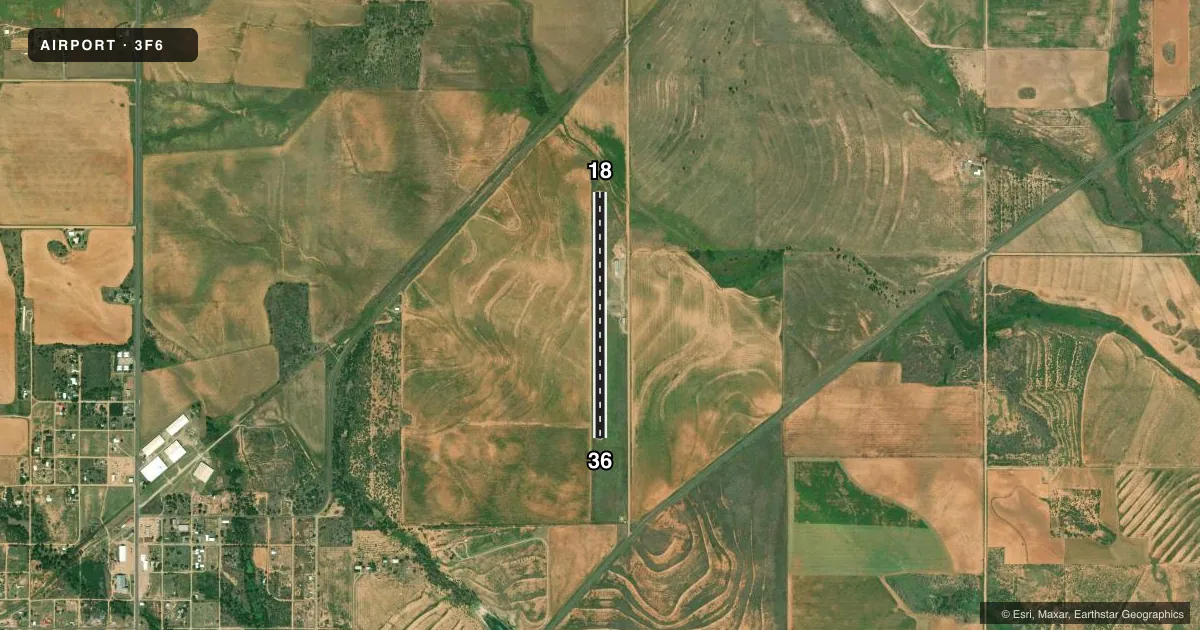
Airport sketch
Runways drawn to scale from FAA survey coordinates, rendered over satellite imagery. Not for navigation.
Approaches & charts
Services on the field
Fuel grades, oxygen, maintenance, ramp storage and lighting — as declared to the FAA by the airport operator.
Fuel & services
- Fuel
- Not available
- Oxygen (bottled)
- Not available
- Oxygen (bulk)
- Not available
- Other services
- AGRI
Ramp & ground
- Transient storage
- Tie-down
- Landing fee
- No fee published
- Customs
- Not available
- Lighting schedule
- SEE RMK
- Beacon schedule
- SS-SR
- Beacon
- White / Green (civil land)(WG)
- Wind indicator
- Lighted
- Segmented circle
- Yes
Fuel & FBOs
Cheapest 100LL and Jet A on the field and nearby. Always confirm with the FBO before taxi.
Airport notes
Surface conditions, obstructions, local procedures, lighting outages and other notes published with each FAA cycle.
General notes
- RWY 18, 10 FT DROP OFF 60 FT DSTC.
- FOR CD CTC FORT WORTH ARTCC AT 817-858-7584.
- RWY 18/36 MARKED AS 17/35.
Lighting notes
- MIRL RWY 18/36 PRESET LOW INTST; TO INCR INTST ACTVT - CTAF.
Approach & departure obstructions
- 184 FT FENCE AT THR 100 FT RIGHT.
- 365 FT BERM 90 FT L AT THLD; 5 FT FENCE 93 FT WEST OF CENTERLINE AT THLD.
- H1APCH RATIO FM EAST 8:1; APCH RATIO FM WEST CROSSES CNTRLN OF RY 17/35.
- H120 FT LGTD WINDSOCK 165 FT NE; 30 FT PLINE 267 FT E; 20 FT BLDG 240 FT SE.
Other notes
- THIS AIRPORT HAS BEEN SURVEYED BY THE NATIONAL GEODETIC SURVEY.
- MANAGERCOUNTY JUDGE.
- H1NOT MAINTAINED. LOOSE GRAVEL AND GRASS ENCROACHMENT ON SURFACE.
VFR map & nearby airports
VFR sectional. Tap any ICAO chip to open that airport.
Key facts · 3F6
Answer card- ICAO
- 3F6
- Name
- DAN E RICHARDS MUNI
- Location
- PADUCAH, TEXAS
- Elevation
- 1,859.5 ft MSL
- Traffic pattern altitude
- 2,859.5 ft MSL (1,000 AGL)
- Control tower
- Non-towered (use CTAF)
- Total runways
- 1
- Longest runway
- 18/36 · 3,186 ft
- Published ILS approaches
- 0
- Published frequencies
- 1
- Magnetic variation
- 5°
- Current flight rules
- VFR
- Current wind
- 190° at 11 kt
- Favored runway now
- RWY 18
DAN E RICHARDS MUNI is in Paducah, Texas. The field elevation is 1,859.5 ft MSL. It has one runway. The longest runway is 18/36 at 3,186 ft on asphalt. The airport is not towered. CTAF is 122.9. No ILS approaches are published here.
The published pattern altitude is not listed. Use the standard 1,000 ft AGL pattern for light piston traffic unless the current FAA Chart Supplement says otherwise. Runway lighting on 18/36 is medium intensity. It starts at low intensity. Pilots can increase it by keying CTAF.
There are no on-field FBOs listed in the facts. Contact the airport operator or the field directly before arrival if you need current fuel or service details. Published remarks also show a few items to brief before you arrive. Runway 18 has a 10-foot drop off 60 feet from the runway. Runway 18 threshold also has a fence close in on the right. The 36 threshold has a berm and a fence near the left side. The runway is marked as 17/35 in the field markings, so verify the current layout before taxi and landing. This is a high-elevation airport, so expect density altitude to matter on warm days. Check performance carefully before departure.