METAR & TAF KCDS
Current METAR
Observed 15:53Z
KCDS 271553Z AUTO 19011KT 10SM CLR 33/17 A2995 RMK AO2 SLP110 T03280172
- Wind
- 190° @ 11 kt
- Visibility
- 10 SM
- Temp / Dew
- 33°C / 17°C
- Altimeter
- 29.95 inHg
- Clouds
- CLR
- Density alt
- 4,546 ft
- Ceiling
- Unlimited
- Rules
- VFR
Airport info & contacts
Manager on record, flight service, ARTCC, attendance schedule and pattern altitude — published by the FAA and refreshed every 28 days.
Location
- From city
- 4 NM W
- VFR sectional
- DALLAS-FT WORTH
- ARTCC
- ZFW · FORT WORTH
- NOTAM facility
- CDS (NOTAM-D)
Airport manager
- Name
- TIFFANY TULLY
- Phone
- 940-937-8309
- Address
- 15716 FM 164, CHILDRESS TX 79201
Flight service · Hours
- FSS FTW
- FORT WORTH1-800-WX-BRIEF
- Attendance
- 0800-1600
Frequencies
Tap any row to copy the frequency to your clipboard.
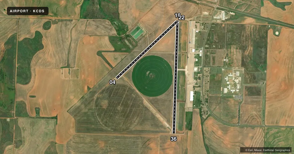
Runways & pattern
Full pagePattern entry · RWY 18
LEFT TRAFFIC| Runway | Heading (°M) | Length | Surface | Traffic |
|---|---|---|---|---|
| 18/36Favored | 176° / 356° | 5,949 ft | ASPH | Standard L |
| 04/22 | 41° / 221° | 4,425 ft | ASPH | Standard L |
Runway end performance
| End | TORA | TODA | ASDA | LDA | VGSI | Approach lights | Obstruction |
|---|---|---|---|---|---|---|---|
| 18 | — | — | — | — | PAPI 2-box left(3°) | — | 25', pole, 1090' from thr, 396' R of cntrln, slope 35 |
| 36 | — | — | — | — | PAPI 2-box left(3°) | — | — |
Declared distances in feet. TORA = takeoff run available, TODA = takeoff distance, ASDA = accelerate-stop, LDA = landing distance.
Airport sketch
Runways drawn to scale from FAA survey coordinates, rendered over satellite imagery. Not for navigation.
Approaches & charts
Services on the field
Fuel grades, oxygen, maintenance, ramp storage and lighting — as declared to the FAA by the airport operator.
Fuel & services
- Fuel
- 100LLA1+
- Other services
- AGRI
Ramp & ground
- Transient storage
- Tie-down
- Landing fee
- No fee published
- Customs
- Not available
- Lighting schedule
- SEE RMK
- Beacon schedule
- SS-SR
- Beacon
- White / Green (civil land)(WG)
- Wind indicator
- Lighted
- Segmented circle
- Yes
Fuel & FBOs
Cheapest 100LL and Jet A on the field and nearby. Always confirm with the FBO before taxi.
Airport notes
Surface conditions, obstructions, local procedures, lighting outages and other notes published with each FAA cycle.
General notes
- AGRICULTURE OPNS NEAR ALL PAVED SFCS.
- FOR CD CTC FORT WORTH ARTCC AT 817-858-7584.
Lighting notes
- MIRL RWY 18/36 PRESET LOW INTST; TO INCR INTST ACTVT - CTAF.
Fuel notes
- 100LL24 HR SELF SVC 100LL AND JET A+. FULL SVC JET A+ AVBL DURG OPRG HRS; AFT HRS CALL 940-937-8309.
Runway surface & condition
- 04/22CLSD INDEFLY.
- 18/36NSTD MIRL RWY 36 THR LGTS 60 FT SOUTH OF RWY END.
Other notes
- THIS AIRPORT HAS BEEN SURVEYED BY THE NATIONAL GEODETIC SURVEY.
- 1UNATTD NEW YEAR'S DAY
- 04/22RWY NOT MNTND; LOOSE GRAVEL AND VEGETATION GROWING THROUGH THE PAVEMENT.
VFR map & nearby airports
VFR sectional. Tap any ICAO chip to open that airport.
Key facts · KCDS
Answer card- ICAO
- KCDS
- Name
- CHILDRESS MUNI
- Location
- CHILDRESS, TEXAS
- Elevation
- 1,953.8 ft MSL
- Traffic pattern altitude
- 2,953.8 ft MSL (1,000 AGL)
- Control tower
- Non-towered (use CTAF)
- Total runways
- 2
- Longest runway
- 18/36 · 5,949 ft
- Published ILS approaches
- 0
- Published frequencies
- 2
- Magnetic variation
- 6°
- Current flight rules
- VFR
- Current wind
- 190° at 11 kt
- Favored runway now
- RWY 18
Childress Muni sits in Childress, Texas. The field elevation is 1,953.8 ft MSL. It has two paved runways, but only runway 18/36 is open. Runway 18/36 is 5,949 ft long. Runway 04/22 is closed indefinitely and is not maintained. The airport is non-towered. CTAF and UNICOM are both 122.8. No ILS approaches are published here. The pattern altitude is not published, so use the current FAA Chart Supplement and local traffic calls before joining.
Boedeker Flying Service is on the field. It carries 100LL and Jet A Prist. The published remarks say 24-hour self-serve 100LL and Jet A plus are available. Full service Jet A plus is available during operating hours. Call the FBO after hours at (940) 937-8309.
A first-time pilot should pay attention to the field condition. The Chart Supplement notes rough taxiways. It also notes grass and weed encroachment near paved surfaces. Agricultural operations are near all paved surfaces. Runway 18/36 has medium intensity lights that start at low intensity. Use the CTAF to increase them. The 36 threshold lights are nonstandard and sit 60 ft south of the runway end. Clearance delivery is handled through Fort Worth ARTCC at 817-858-7584. Check the current Chart Supplement before you go for any operational updates.