METAR & TAF 37F
37F does not publish a METAR.
Showing the nearest reporting station: KRPH (GRAHAM MUNI) · 56.1 NM away. Conditions at 37F may differ.
METAR · KRPH
Observed 13:15Z
KRPH 271315Z AUTO 00000KT 10SM CLR 27/21 A2995 RMK AO2 T02650208 $
- Wind
- 000° @ 0 kt
- Visibility
- 10 SM
- Temp / Dew
- 27°C / 21°C
- Altimeter
- 29.95 inHg
- Clouds
- CLR
- Density alt
- 3,231 ft
- Ceiling
- Unlimited
- Rules
- VFR
Airport info & contacts
Manager on record, flight service, ARTCC, attendance schedule and pattern altitude — published by the FAA and refreshed every 28 days.
Location
- From city
- 3 NM E
- VFR sectional
- DALLAS-FT WORTH
- ARTCC
- ZFW · FORT WORTH
- NOTAM facility
- FTW (NOTAM-D)
Airport manager
- Name
- DAVID TREVINO
- Phone
- 940-422-4331
- Address
- 121 E MAIN ST,, DRAWER 39, MUNDAY TX 76371
Flight service · Hours
- FSS FTW
- FORT WORTH1-800-WX-BRIEF
- Attendance
- MON-FRI · 0800-1600
Frequencies
Tap any row to copy the frequency to your clipboard.
Runways & pattern
Full pagePattern entry · RWY 17
LEFT TRAFFICRunway end performance
| End | TORA | TODA | ASDA | LDA | VGSI | Approach lights | Obstruction |
|---|---|---|---|---|---|---|---|
| 35 | — | — | — | — | — | — | 67', pline, 3100' from thr, 0' R of cntrln, slope 43 |
Declared distances in feet. TORA = takeoff run available, TODA = takeoff distance, ASDA = accelerate-stop, LDA = landing distance.
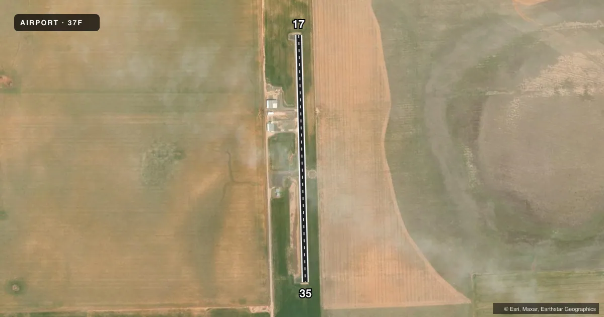
Airport sketch
Runways drawn to scale from FAA survey coordinates, rendered over satellite imagery. Not for navigation.
Approaches & charts
Services on the field
Fuel grades, oxygen, maintenance, ramp storage and lighting — as declared to the FAA by the airport operator.
Fuel & services
- Fuel
- Not available
- Oxygen (bottled)
- Not available
- Oxygen (bulk)
- Not available
- Airframe repair
- Not available
- Power plant repair
- Not available
- Other services
- AGRI
Ramp & ground
- Transient storage
- Tie-down
- Customs
- Not available
- Lighting schedule
- SEE RMK
- Beacon schedule
- SS-SR
- Beacon
- White / Green (civil land)(WG)
- Wind indicator
- Lighted
- Segmented circle
- Yes
Fuel & FBOs
Cheapest 100LL and Jet A on the field and nearby. Always confirm with the FBO before taxi.
Airport notes
Surface conditions, obstructions, local procedures, lighting outages and other notes published with each FAA cycle.
General notes
- FOR CD CTC FORT WORTH ARTCC AT 817-858-7584.
Lighting notes
- ACTVT LIRL 17/35 - CTAF.
Other notes
- MANAGERCITY/AMGR.
VFR map & nearby airports
VFR sectional. Tap any ICAO chip to open that airport.
Key facts · 37F
Answer card- ICAO
- 37F
- Name
- MUNDAY MUNI
- Location
- MUNDAY, TEXAS
- Elevation
- 1,474 ft MSL
- Traffic pattern altitude
- 2,474 ft MSL (1,000 AGL)
- Control tower
- Non-towered (use CTAF)
- Total runways
- 1
- Longest runway
- 17/35 · 3,200 ft
- Published ILS approaches
- 0
- Published frequencies
- 1
- Magnetic variation
- 8°
- Current flight rules
- VFR
- Current wind
- 000° at 0 kt
- Favored runway now
- –
Munday Muni sits in Munday, Texas. The field elevation is 1,474 ft MSL. It has one runway, 17/35, at 3,200 ft of asphalt. There is no control tower. CTAF is 122.9. No ILS approaches are published here.
Pattern altitude is not published in the facts, so use the standard 1,000 ft AGL pattern for light piston operations unless the current Chart Supplement says otherwise. Low intensity runway lights on 17/35 are activated by the CTAF. That helps for night arrivals, but you still need to verify lighting procedures before you go.
Petty Flying Service is on the field. It carries 100LL and Jet A. Call (940) 422-4511 for current service details before arrival. For clearance delivery, contact Fort Worth ARTCC at 817-858-7584. The airport is managed by the city manager. With one short runway and no published ILS, this is a simple VFR field. Plan for standard small-airport operations and check the current Chart Supplement for anything that may affect your arrival.