METAR & TAF 60F
60F does not publish a METAR.
Showing the nearest reporting station: KCWC (KICKAPOO DOWNTOWN) · 40.5 NM away. Conditions at 60F may differ.
METAR · KCWC
Observed 12:55Z
KCWC 271255Z AUTO 18006KT 10SM CLR 26/18 A2995 RMK AO2 T02560184 PWINO
- Wind
- 180° @ 6 kt
- Visibility
- 10 SM
- Temp / Dew
- 26°C / 18°C
- Altimeter
- 29.95 inHg
- Clouds
- CLR
- Density alt
- 2,949 ft
- Ceiling
- Unlimited
- Rules
- VFR
Airport info & contacts
Manager on record, flight service, ARTCC, attendance schedule and pattern altitude — published by the FAA and refreshed every 28 days.
Location
- From city
- 3 NM N
- VFR sectional
- DALLAS-FT WORTH
- ARTCC
- ZFW · FORT WORTH
- NOTAM facility
- FTW (NOTAM-D)
Airport manager
- Name
- JEFF BRASHER
- Phone
- 940-889-0025
- Address
- PO BOX 31, SEYMOUR TX 76380
Flight service · Hours
- FSS FTW
- FORT WORTH1-800-WX-BRIEF
- Attendance
- Unattended
Frequencies
Tap any row to copy the frequency to your clipboard.
Runways & pattern
Full pagePattern entry · RWY 17
LEFT TRAFFICRunway end performance
| End | TORA | TODA | ASDA | LDA | VGSI | Approach lights | Obstruction |
|---|---|---|---|---|---|---|---|
| 17 | — | — | — | — | PAPI 2-box left(3°) | — | 4', fence, 201' from thr, 200' R of cntrln, slope 0 |
| 35 | — | — | — | — | — | — | 25', hangar, 207' from thr, 249' R of cntrln, slope 0 |
Declared distances in feet. TORA = takeoff run available, TODA = takeoff distance, ASDA = accelerate-stop, LDA = landing distance.
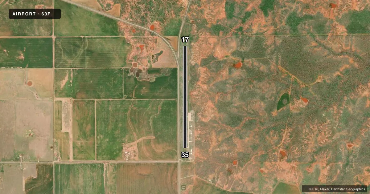
Airport sketch
Runways drawn to scale from FAA survey coordinates, rendered over satellite imagery. Not for navigation.
Approaches & charts
Services on the field
Fuel grades, oxygen, maintenance, ramp storage and lighting — as declared to the FAA by the airport operator.
Fuel & services
- Fuel
- Not available
- Oxygen (bottled)
- Not available
- Oxygen (bulk)
- Not available
- Airframe repair
- Not available
- Power plant repair
- Not available
Ramp & ground
- Transient storage
- Tie-down
- Landing fee
- No fee published
- Customs
- Not available
- Lighting schedule
- SS-SR
- Beacon schedule
- SS-SR
- Beacon
- White / Green (civil land)(WG)
- Wind indicator
- Lighted
- Segmented circle
- Yes
Fuel & FBOs
Cheapest 100LL and Jet A on the field and nearby. Always confirm with the FBO before taxi.
Airport notes
Surface conditions, obstructions, local procedures, lighting outages and other notes published with each FAA cycle.
General notes
- FOR CD CTC FORT WORTH ARTCC AT 817-858-7584.
Approach & departure obstructions
- 174 FT FENCE 200 L & R, 0-199 FT DSTC.
- 354 FT FENCE 203 FT L AT RWY THR; 20 FT HNGRS 75 FT DSTC, 240 FT R.
- 17ALSO 16 FT TREE, 220 FT DSTC, 36 FT L, 1:1.
- 17FENCE MADE OF PIPES.
Other notes
- MANAGERCITY ADMINISTRATOR
VFR map & nearby airports
VFR sectional. Tap any ICAO chip to open that airport.
Key facts · 60F
Answer card- ICAO
- 60F
- Name
- SEYMOUR MUNI
- Location
- SEYMOUR, TEXAS
- Elevation
- 1,344 ft MSL
- Traffic pattern altitude
- 2,344 ft MSL (1,000 AGL)
- Control tower
- Non-towered (use CTAF)
- Total runways
- 1
- Longest runway
- 17/35 · 4,300 ft
- Published ILS approaches
- 0
- Published frequencies
- 1
- Magnetic variation
- 7°
- Current flight rules
- VFR
- Current wind
- 180° at 6 kt
- Favored runway now
- RWY 17
Seymour Muni is in Seymour, Texas. The field elevation is 1,344 ft MSL. It has one runway, 17/35, which is 4,300 ft long and asphalt. There is no control tower. CTAF is 122.9. No ILS approaches are published here.
Pattern altitude is not published in the facts, so use the standard 1,000 ft AGL for light piston traffic unless the current Chart Supplement says otherwise. The published remarks also note the city administrator is the airport manager. That is the contact point for airport matters.
Watch the runway environment closely. There is a 4-foot pipe fence near runway 17. It sits 200 feet left and right from zero to 199 feet distance from the runway 17 end. There is also a 16-foot tree 220 feet from runway 17, 36 feet left, with a one-to-one clearance slope. Near runway 35, there is a 4-foot fence at the threshold. There are also 20-foot hangars 75 feet away and 240 feet right. Clearance delivery is handled through Fort Worth ARTCC at 817-858-7584. For a first-time arrival, this is a non-towered field with published obstructions near both ends, so brief your approach carefully and confirm the current Chart Supplement before you go.